This item has been sold, but you can get on the Waitlist to be notified if another example becomes available, or purchase a digital scan.
1911 Clason Map of Denver, Colorado
Denver-clason-1911$250.00

Title
Denver Colorado.
1911 (dated) 19.25 x 20.25 in (48.895 x 51.435 cm) 1 : 31680
1911 (dated) 19.25 x 20.25 in (48.895 x 51.435 cm) 1 : 31680
Description
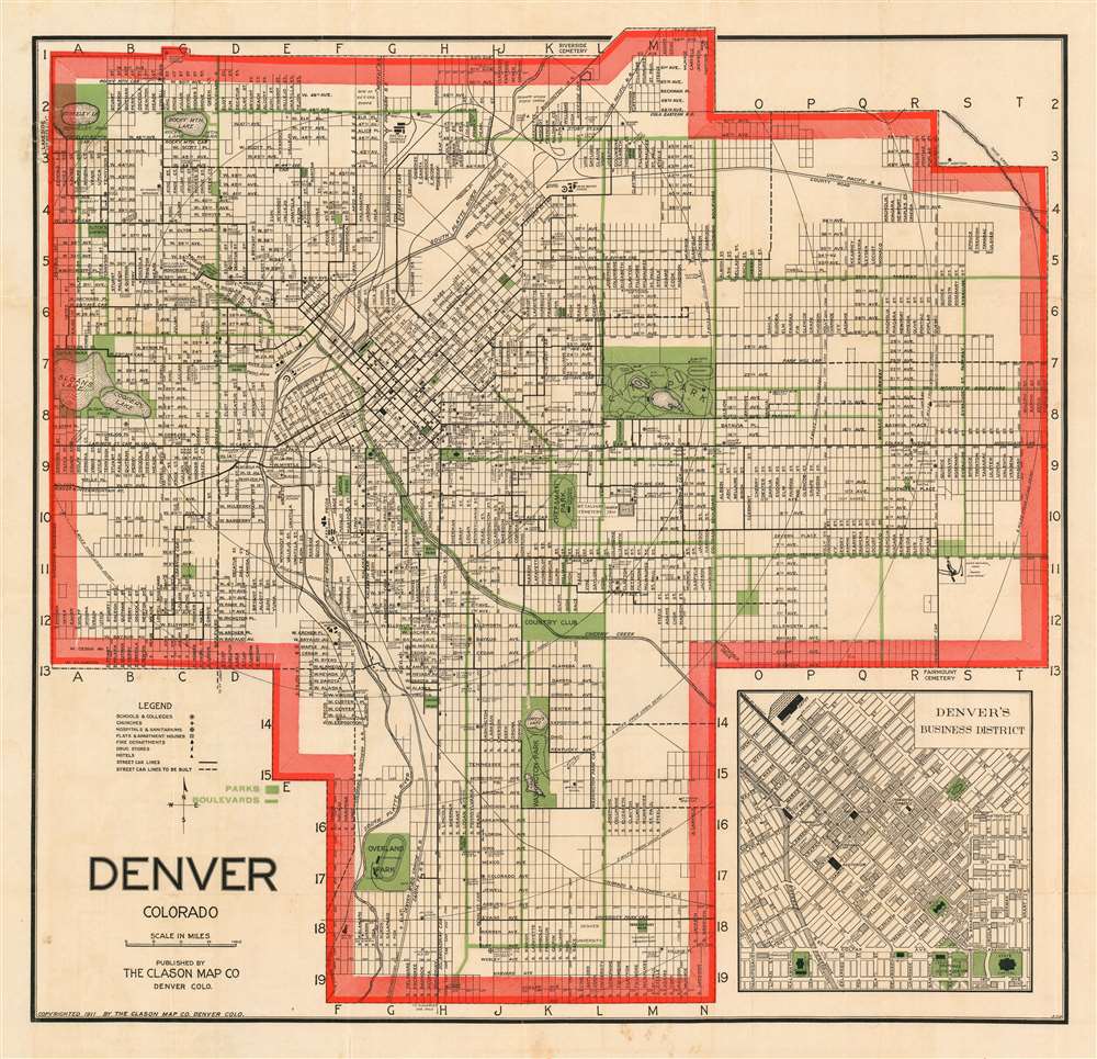
An attractive example of George Clason's 1907 guidebook and map of Denver, Colorado. This map covers the growing city from Berkley Lake to Yale Avenue and from Sloans Lake to Yosemite Street. Concentric circles mark each mile's distance from Union Depot. Though the map has not expanded yet to include Aurora (as it would be in later editions) the municipality is marked in manuscript along Colfax Avenue between Ulster and Wabash streets. An inset in the lower right quadrant details the Denver Business District.
’It is no uncommon sight to see green lawns in mid-winter’
The map, in conjunction with the included Clason's 1911 Guide to Denver, has been updated since its 1907 inception to emphasize the development of parks and other green spaces that were either not present, or not presented in the earlier edition. While the 1907 also highlighted Denver's dozens of parks, for the first time this 1911 issue marks out the city's boulevards in green on the general map. The map also shows the locations of important buildings - not only municipal structures and hospitals and fire stations and the like, but apartment buildings, hotels and even drug stores. The guide praises Denver as 'That Live Wire Town... a city of culture, refinement and education', discusses the city's history, and goes on to enumerate its specific features, ranging from its altitude (one mile above sea level!) its sidewalks (392 miles!) and touting the purest water in the world.Ebert Addition School, Sand Creek
An odd alteration in Denver's northeastern border appears to have occurred between 1907 and 1911. An area, spanning between 43rd and 48th avenues and between Quebec Street and Yosemite Street here is shown outside Denver's city limits, where it was included on the 1907 map. The area contains no marked streets, and shows only a portion of Sand Creek and the location of the Ebert Addition School. Why this region should have been alienated from the city is not evident.Publication History and Census
Clason’s guide maps appeared in multiple editions, and are found for the most part in 1920s issues. We have identified one 1907 issue of this map; this 1911 issue appears to be the second. We identify only five examples catalogued with OCLC in the Buffalo and Erie County Public Library, Southern Methodist University, the University of Wisconsin at Milwaukee, Denver Public Library, and History Colorado.Cartographer
George Samuel Clason (November 7, 1874 - 1957) was born in the city of Louisiana, Missouri in 1874. As a young man, Clason studied at the University of Nebraska before joining the United States Army in 1898 to fight in the Spanish American War. After the war, he moved to Denver, Colorado where in 1905 he founded the Clason Map Company, thus starting his lucrative publishing career. Clason initially focused on mining and mineral maps - capitalizing on the Colorado and Nevada mining industry, but quickly transitioned to railroad maps, city maps, and by the 1920s, road maps. As the company expanded, Clason opened a secondary office in Chicago, Illinois - then a rising map publishing center and railroad hub. At least one other satellite office was opened in Los Angeles. Among his many achievements, Clason is credited with producing the first modern road atlas of the United States. In the late 1920s, Clason also published a series of get-rich-quick pamphlets in the form of parables. The most famous of these is The Richest Man in Babylon. This tells the story of Arkad, a citizen of Babylon famed for his great wealth and generosity who shares his wit and wisdom with his fellow Babylonians. In 1949, Clason moved to Napa, California to retire and found a social club for retired gentlemen. More by this mapmaker...
Source
Classon, G., Clason's Guide to Denver with Map, (Denver: Clason Map Company) 1911.
Condition
Good condition. Map has been flattened and backed with archival tissue, very minor loss at some folds. Original guidebook separate and present.
References
OCLC 233971166.