
1943 Daniel-Smith City Plan of Denver, Colorado

This item has been sold.
Map of Denver / Denver Map and Guide.
Training U.S. Army Air Forces in Denver.
Choose a Collection:
- Digital Map Information
- Suitable for large format printing
- Full resolution TIFF file
- ICC color profile embedded
- Delivered instantly via download link
This Item
Enquire
Training U.S. Army Air Forces in Denver.
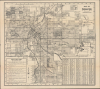
This is a c. 1943 Daniel-Smith city plan of Denver, Colorado. Prepared for 'service men and women,' the map reflects the profound impact that World War II (1939 - 1945) left on the city.A Closer Look
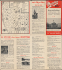
The map covers the main part of Denver and labels streets, highways, streetcar lines, bus lines, railroads, and public institutions such as parks, golf courses, hospitals, schools (including Denver University and the Colorado Women's College), and other features throughout. Prominent at the bottom-right is Lowry Field, which housed the Photography, Armament, and Clerical instruction functions of the Air Corps Technical School. Nearby Buckley Field, just beyond the scope of the map but referred to here, also conducted training functions, preparing bomber armorers, and later trained airmen of the Air Transport Command's Alaskan Wing in how to operate aircraft and survive in cold temperatures. The verso contains an inset map of downtown Denver with 'places of interest to the soldier,' including churches and USO clubs. More information on these locations is provided in the accompanying text.Denver during World War II
During World War II, Denver emerged as a strategic center for military training, logistics, and industrial production. The city hosted key facilities such as Lowry Field, which became an important training site for aerial photography, armament, and technical specialties essential to the Army Air Forces. Denver's location away from the coasts and potential foreign attack routes made it ideal for military expansion, and tens of thousands of service members passed through its bases. The presence of these installations transformed the city's economy and daily life, bringing a rapid influx of personnel and federal investment that reshaped neighborhoods, transportation, and public services.Denver played an important role in wartime manufacturing and administrative work. The Denver Ordnance Plant in nearby Lakewood produced millions of rounds of ammunition, employing a workforce that included many women and migrants from rural Colorado and neighboring states. Downtown Denver housed regional offices for federal agencies tasked with rationing, price control, and resource management, reinforcing the city's position as an administrative hub for the Mountain West. By the end of the war, these developments had dramatically expanded Denver's population and industrial base, laying the foundations for the city's postwar growth and its emergence as a major metropolitan center in the interior United States.
Publication History and Census
This map was prepared and published by the Daniel-Smith Company during World War II. It is undated, but from context (the names of Buckley Field and Denver Municipal Airport), it can be dated to between 1942 and 1944. Several editions of a map with this title appear in the OCLC, but none of the catalog descriptions match the present map. The closest match is a c. 1944 edition with similar military-themed content, held by the Denver Public Library and Syracuse University.Condition
Good. Wear along original fold lines. Verso repairs to fold separations. Slight loss at a few fold intersections. Text and map of downtown Denver on verso.
References
OCLC 7126651 (slightly different, likely later, edition).