
1950 ABC Air Guide World Map of Passenger Air Routes

This item has been sold.
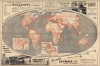
The ABC Air Guide Map of the World (based on Mollweide's projection) showing Chief Passenger Air Lines.
Postwar Passenger Air Travel Boom.
Choose a Collection:
- Digital Map Information
- Suitable for large format printing
- Full resolution TIFF file
- ICC color profile embedded
- Delivered instantly via download link
This Item
Enquire
Postwar Passenger Air Travel Boom.
This is a c. 1950 map of the world depicting major passenger airline routes, prepared for the ABC Airways Guide in Dunstable, England by Index Publishers and Thomas Skinner. The map emerged at the height of the Post-WWII passenger airline boom, which promised a new age of global peace, mobility, and interconnectedness - note how there are no national boundaries. The complex network of air routes is also notable for its comprehensiveness, reaching deep into the decolonizing world and the Soviet Union.A Closer Look
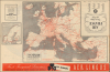
The map presents the world on a pseudocylindrical Mollweide Projection. The routes of major passenger airlines are traced in red and numbered, corresponding to indexes in the ABC Airways Guide. Two inset maps depict the eastern United States and the Caribbean in greater detail, while a map covering much of Europe and the Mediterranean with an inset of Scandinavia appears on the verso.Several advertisements relating to the airline industry surround the maps, including an advertisement at the top for Daimler, which is actually for a British car manufacturer with a long, complicated relationship to the German Daimler Motoren Gesellschaft.
Many of the passenger and freight airplanes of this era were decommissioned military aircraft. For instance, the plane presented here in England's and Perrott's freight advertisement at the bottom-left is an Avro Lancaster, a workhorse heavy bomber for the Royal Air Force in World War II.
Postwar Passenger Air Boom
The early post-World War II period saw an extraordinary expansion in international passenger air travel, driven largely by the availability of surplus military aircraft and rapidly advancing aviation technology. Allied wartime production created fleets of long-range transports, such as the Douglas C-47 and C-54, which were easily adapted for civilian use and enabled airlines to establish or expand transoceanic routes at relatively low cost. Flag carriers such as Pan American, BOAC, and Air France moved quickly to connect major cities across the Atlantic and Pacific. At the same time, the newly formed International Civil Aviation Organization (ICAO), established in 1944, helped standardize safety procedures, air navigation, and bilateral agreements, providing the industry with a regulatory framework in which it could grow. This environment encouraged governments to view international aviation as a symbol of prestige and a tool of diplomacy, prompting substantial public investment in airports, airways, and national airlines.By the late 1940s and early 1950s, new generations of purpose-built civilian airliners, including the pressurized Lockheed Constellation and Douglas DC-6, greatly improved comfort, reliability, and speed, making long-distance air travel more appealing to a wider segment of the public. These aircraft reduced transatlantic crossing times to around half a day and offered amenities that compared favorably with those of ocean liners, which until then had dominated intercontinental travel. Airlines also introduced more sophisticated route networks, interchange agreements, and connecting services, facilitating truly global mobility. Although fares remained high and air travel was still primarily the domain of business travelers and wealthy tourists, the postwar decade laid the foundation for the mass international air travel that would emerge with the Jet Age.
Publication History and Census
This map was prepared by Index Publishers and published by Thomas Skinner and Company circa 1950 for the ABC Airways Guide. The ABC Airways Guide was published in multiple editions between the early 1950s and mid-1970s, which can be distinguished by the title as well as the name of the maker and publisher (see notes in OCLC 6170796), with this being an early and perhaps first edition of the guide's map. Although conceptually similar, the appearance of the guide's map changed considerably from year to year. The OCLC records one example of a map with this title held by the Library of Congress and dated to c. 1950.Condition
Very good. Light wear along original fold lines. Slight loss at a few fold intersections. Airways Guide Map of Europe on verso.
References
OCLC 7716132.