1991 El Sol / Arroyo Spanish-language Map of Operation Desert Storm
DesertStorm-elsol-1991$850.00


Title
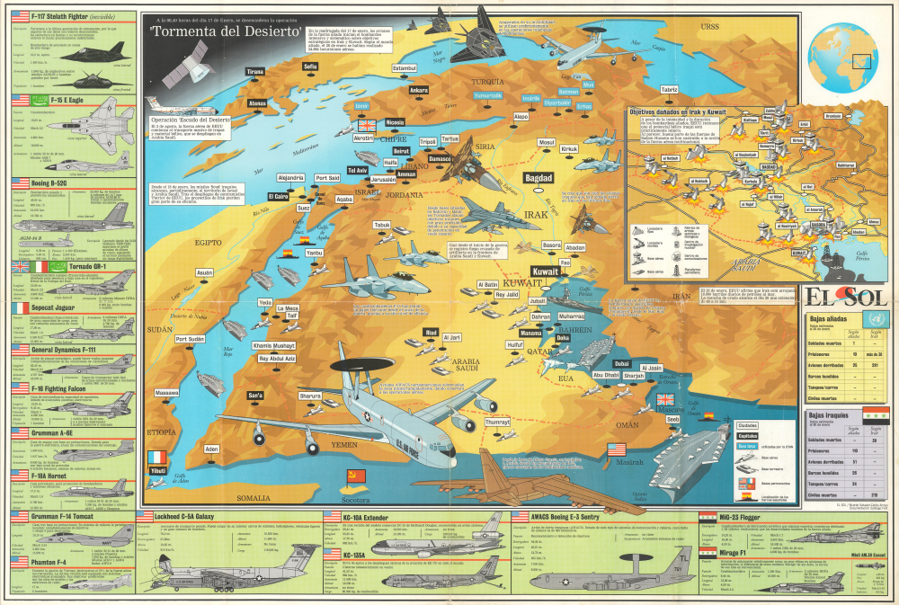
A la 00,00 horas del día 17 de enero, se desencadena la operación 'Tormenta del Desierto.'
1991 (undated) 21.5 x 31.25 in (54.61 x 79.375 cm)
1991 (undated) 21.5 x 31.25 in (54.61 x 79.375 cm)
Description
This is a curious large-format c. 1991 Spanish-language map of Operation Desert Storm, published as a supplement to the ephemeral periodical El Sol. Produced during the conflict, it represents an early effort to depict the complex military maneuvers and technologies at play.
Having badly miscalculated the international response to the invasion of Kuwait, Saddam tried various means to inflict damage on Saudi Arabia, other regional Coalition partners, and Israel, to little avail. Although nominally armed with fairly good Soviet equipment, Iraq's forces were depleted by the recent conflict with Iran and were at least a generation behind the latest American and Coalition hardware, which included laser-guided munitions, electronic warfare aircraft, and satellite communications. The result was a complete rout of Iraqi forces, their ejection from Kuwait, and Iraq becoming an international pariah state.
A Closer Look
Coverage includes a large portion of the Middle East centered on Iraq, Saudi Arabia, and the Persian Gulf projected with some curvature of the Earth to allow for the inclusion of a satellite at the top-left. Major cities are labeled throughout, while coloration and illustration give some sense of terrain and elevation. However, more attention is given to military hardware, particularly the ships and planes employed by the United States and its allies against Iraqi targets. Along the left and bottom of the sheet are drawings and specifications for a wide range of planes flown by American, Saudi, Italian, and French pilots, including fighters, bombers, reconnaissance planes, and supply planes, as well as the aircraft and missiles of the Iraqi Air Force at the bottom-right. At the right is an inset map of targets damaged in Iraq. At the top right is a depiction of the globe with the area covered by the main map indicated. Below the insets are tables listing the casualties of Coalition and Iraqi forces.Operation 'Desert Storm'
Operation 'Desert Storm' was the second phase of the Gulf War between the Iraqi Republic and a multinational coalition led by the United States, the first being 'Desert Shield.' The conflict began when Saddam Hussein's Iraq invaded Kuwait on August 2, 1990, the result of disputes over oil drilling rights and Iraqi debts to Kuwait incurred during the costly Iran-Iraq War (1980 - 1988). The invasion of Kuwait was condemned internationally, and the United States and its allies rushed military resources to the region ('Desert Shield'), eventually building a coalition of 42 countries who contributed militarily to the effort. A U.N. Security Council Resolution called for 'all necessary means' to force Iraq's withdrawal from Kuwait, and Coalition forces prepared a counter-attack against Iraqi forces.Having badly miscalculated the international response to the invasion of Kuwait, Saddam tried various means to inflict damage on Saudi Arabia, other regional Coalition partners, and Israel, to little avail. Although nominally armed with fairly good Soviet equipment, Iraq's forces were depleted by the recent conflict with Iran and were at least a generation behind the latest American and Coalition hardware, which included laser-guided munitions, electronic warfare aircraft, and satellite communications. The result was a complete rout of Iraqi forces, their ejection from Kuwait, and Iraq becoming an international pariah state.
Publication History and Census
This map was published in 1991 as a supplement to the Spanish-language publication El Sol. Several publications use this name, but it most likely refers to the official magazine of the Asociación de Maestros de Puerto Rico. The map is undated, but given the latest dates mentioned and the low numbers of casualties recorded, it likely was prepared before the conclusion of Operation Desert Storm in late January or early February 1991. The map is attributed to Ricardo Salvador-Carlos Arroyo and Santiago Font. We have been unable to locate this map in any institutional collections.Condition
Good. Light wear on old fold lines. A few points of verso stabilization.