1753 Bellin Map of The Straits of Magellan, Chile, South America
DetroitDeMagellan-bellin-1780$195.00

Title
Carte Reduite du Detroit de Magellan Dressee sur les Journaux des Navigateurs.
1780 (dated) 8.5 x 13.5 in (21.59 x 34.29 cm) 1 : 1820000
1780 (dated) 8.5 x 13.5 in (21.59 x 34.29 cm) 1 : 1820000
Description
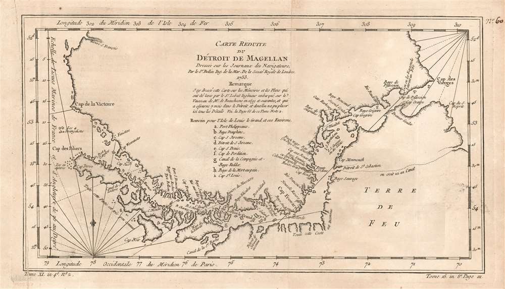
This is a beautiful 1753 Bellin map of the Straits of Magellan, South America. It covers the crucial strait located at the southern tip of the South American mainland, just north of Tierra del Fuego. The map extends from Cap des Vierges to Cap de la Victoire, rendering the region in detail, noting the coastlines, capes, harbors, islands and other important topographical features. Since its discovery by the Portuguese circumnavigator Ferdinand Magellin in 1520, this natural channel linked the Atlantic and Pacific Oceans despite the challenge in negotiating its unpredictable winds and currents. Until the construction of the Panama Canal it remained the fastest connection between the two oceans.
The map is simply but elegantly engraved, with rhumb lines in the ocean areas; the one indicating north is marked with a fleur de lis.. Below the title, is a notation crediting the details of the map to a Mr. Labat, engineer accompanying Jacques Gouin de Beauchesne's 1699 voyage to the Pacific (the first French trading expedition to that ocean.) A key is included, identifying nine locations marked on the map.
The map is simply but elegantly engraved, with rhumb lines in the ocean areas; the one indicating north is marked with a fleur de lis.. Below the title, is a notation crediting the details of the map to a Mr. Labat, engineer accompanying Jacques Gouin de Beauchesne's 1699 voyage to the Pacific (the first French trading expedition to that ocean.) A key is included, identifying nine locations marked on the map.
Publication History and Census
This map was engraved in 1753 for inclusion in La Harpe's Abrégé de l'histoire générale des voyages. The separate map appears on the market from time to time, and in various editions appears in nineteen institutional collections. La Harpe's work is well represented in institutions.Cartographer
Jacques-Nicolas Bellin (1703 - March 21, 1772) was one of the most important cartographers of the 18th century. With a career spanning some 50 years, Bellin is best understood as geographe de cabinet and transitional mapmaker spanning the gap between 18th and early-19th century cartographic styles. His long career as Hydrographer and Ingénieur Hydrographe at the French Dépôt des cartes et plans de la Marine resulted in hundreds of high quality nautical charts of practically everywhere in the world. A true child of the Enlightenment Era, Bellin's work focuses on function and accuracy tending in the process to be less decorative than the earlier 17th and 18th century cartographic work. Unlike many of his contemporaries, Bellin was always careful to cite his references and his scholarly corpus consists of over 1400 articles on geography prepared for Diderot's Encyclopedie. Bellin, despite his extraordinary success, may not have enjoyed his work, which is described as "long, unpleasant, and hard." In addition to numerous maps and charts published during his lifetime, many of Bellin's maps were updated (or not) and published posthumously. He was succeeded as Ingénieur Hydrographe by his student, also a prolific and influential cartographer, Rigobert Bonne. More by this mapmaker...
Source
De la Harpe, Abrégé de l'histoire générale des voyages, (Paris) 1780.
Condition
Good. Original fold lines. Manuscript pagination in upper right margin. Mended tear along left border.
References
OCLC 163344058.