This item has been sold, but you can get on the Waitlist to be notified if another example becomes available, or purchase a digital scan.
1845 Weakley Land Office Map of Alabama
DiagramAlabama-weakley-1845$87.50

Title
A Diagram of the State of Alabama.
1845 (dated) 23.25 x 12 in (59.055 x 30.48 cm) 1 : 1225000
1845 (dated) 23.25 x 12 in (59.055 x 30.48 cm) 1 : 1225000
Description
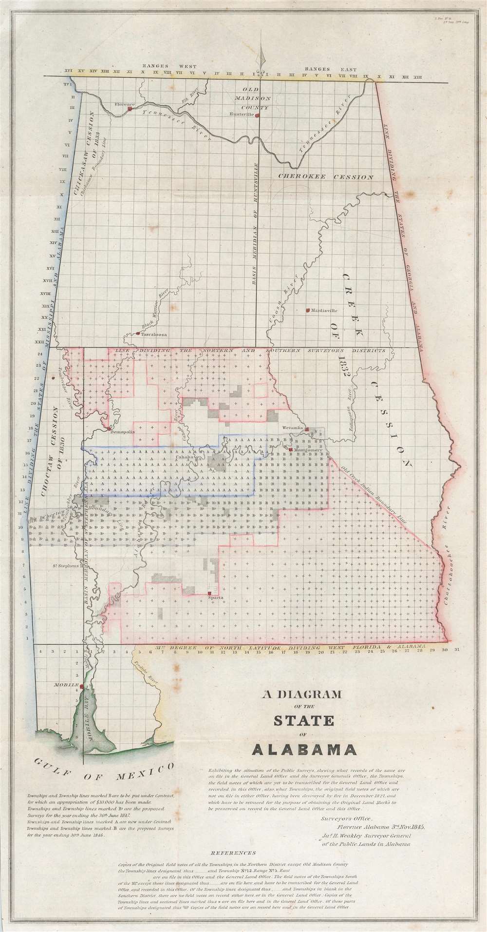
This is an 1841 James Weakley General Land Office map of Alabama, representing the work of the Alabama Land Survey as of November 1845. The state is divided into townships, many of which in southern Alabama were already sold or under contract. Various rivers and cities are also identified, including Florence, Huntsville, Sparta, and Wetumka, among others.
A Short Explanation of a Township
The township was created as the measure of the Public Land Survey System, which was first widely implemented to survey the Northwest Ordinance. The Public Land Survey System allowed for the systematic surveying and mapping of any territory gained by the United States.American Indian Cessions and the Trail of Tears
Following shortly on the events associated with the Trail of Tears and the Indian Removal Act in the late 1830s, this map identifies the seized American Indian lands, referring to them as the Cherokee Cession, the Choctaw Cession of 1830, the Chickasaw Cession of 1833, and the Creek Cession of 1832. Between 1830 and 1850, approximately 60,000 Native Americans were forcibly removed from their land in the American Southeast and relocated to Indian Territory (modern-day Oklahoma).Publication History and Census
This map was created under the supervision of James H. Weakley, Surveyor General of the Public Lands in Alabama and published in a report to the United States Senate in 1845. Seven examples of the separate map are cataloged in OCLC: New York Public Library, Michigan State University, the Newberry Library, the University of Virginia, the Birmingham Public Library, the University of Wyoming, and Brigham Young University.CartographerS
James Harvey Weakley (March 24, 1798 - September 3, 1856) was an American engineer and surveyor. Born in Halifax County, Virginia, Weakley grew up in Tennessee and attended Cumberland University. He joined the surveyor-general's office in Alabama in 1817 as the chief clerk. He held that position until General John Coffee died in 1833. After General Coffee's death, Andrew Jackson appointed Weakley Surveyor of Public Lands of Alabama. Weakley served as Surveyor of Public Lands until 1851 when Congress abolished the position. Then he worked in the cotton commission business until his death in 1856. He married Ellen M. Donegan (1804 - 1883), a native of Cork, Ireland, on August 26, 1830. After Weakley's death, Ellen moved to Nashville where she spent the rest of her life at the Convent Academy of St. Cecilia. More by this mapmaker...
The General Land Office (GLO) (1812 - 1946) was an independent agency of the United States government responsible for public domain lands in the United States. Created in 1812, it took over functions previously conducted by the Department of the Treasury. The GLO oversaw the surveying, platting, and sale of public lands in the western United States. It also administered the Preemption Act of 1841, which allowed individuals who were already living on federal land to purchase up to 160 acres of land before it was offered for sale to the general public, if they met certain requirements. Following the passage of the Homestead Act in 1862, which was also administered by the GLO, claims under the Preemption Act sharply decreased. The GLO became a part of the newly-created Department of the Interior in 1849. In 1891 Grover Cleveland and Congress created 17 forest reserves, due to public concern over forest conservation, which were initially managed by the GLO, until they were transferred to the Forest Service in 1905. In 1946 the Government Land Office was merged with the United States Grazing Service to become the Bureau of Land Management. Today the Bureau of Land Management administers the roughly 246 million acres of public land remaining under federal ownership. Learn More...
Condition
Very good. Light wear along original fold lines. Foxing.
References
OCLC 1039889493; 809367845.