This item has been sold, but you can get on the Waitlist to be notified if another example becomes available, or purchase a digital scan.
1845 Conway Land Office Map of Missouri
DiagramMissouri-conway-1845$100.00

Title
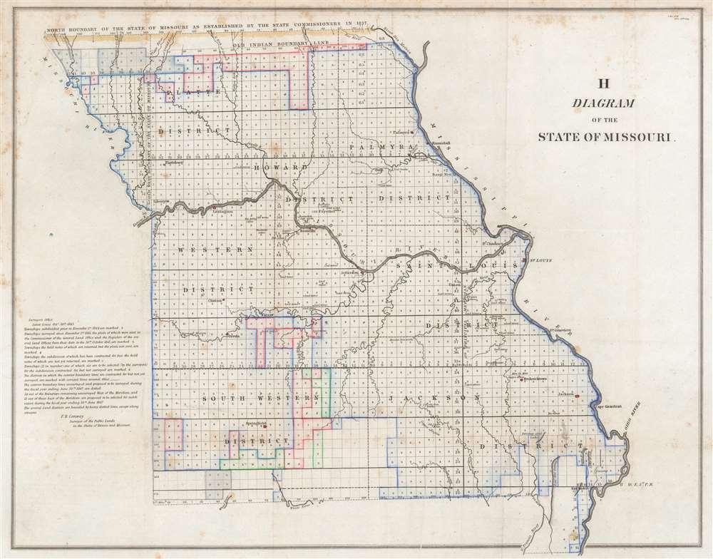
H Diagram of the State of Missouri.
1845 (dated) 18.25 x 23 in (46.355 x 58.42 cm) 1 : 1220000
1845 (dated) 18.25 x 23 in (46.355 x 58.42 cm) 1 : 1220000
Description
This is an 1845 Frederick R. Conway Land Office survey map of Missouri. The state has been platted into townships, with letters 's', 'z', 'o', and 'x' indicating the status of each township's survey. Districts within the state are labeled, and cities and towns are identified, including St. Louis, Palmyra, and Hannibal. The evolution of Missouri's borders is traced as well, with lines marking the 'Old Indian Boundary Line', the 'north boundary of the State if Missouri as established by the state commissioners in 1837', and the 'old west boundary of the State of Missouri.'
A Short Explanation of a Township
The township was created as the measure of the Public Land Survey System, which was first widely implemented to survey the Northwest Ordinance. The Public Land Survey System allowed for the systematic surveying and mapping of any territory gained by the United States.Publication History and Census
This map was created by Frederick R. Conway for publication in a report to the U.S. Senate in 1845. We note six examples cataloged in OCLC which are part of the collections at Yale University, the Thomas Fisher Rare Book Library in Toronto, the Wisconsin Historical Society, the Missouri University of Science and Technology, the Denver Public Library, and the University of Oregon.CartographerS
Frederick Rector Conway (July 4, 1799 - December 16, 1874) was an American surveyor and cartographer. Born in Tennessee, Conway was one of seven brothers. He and his family moved from Tennessee to Missouri in 1818. Conway was appointed the Surveyor General of Illinois and Missouri at St. Louis on May 12, 1845 and was notified the following day. He was also known by another title, Surveyor of the Public Lands in the States of Illinois and Missouri. According to an obituary, Conway had been sick for some time at the time of his death, but his illness had not been considered life threatening. More by this mapmaker...
The General Land Office (GLO) (1812 - 1946) was an independent agency of the United States government responsible for public domain lands in the United States. Created in 1812, it took over functions previously conducted by the Department of the Treasury. The GLO oversaw the surveying, platting, and sale of public lands in the western United States. It also administered the Preemption Act of 1841, which allowed individuals who were already living on federal land to purchase up to 160 acres of land before it was offered for sale to the general public, if they met certain requirements. Following the passage of the Homestead Act in 1862, which was also administered by the GLO, claims under the Preemption Act sharply decreased. The GLO became a part of the newly-created Department of the Interior in 1849. In 1891 Grover Cleveland and Congress created 17 forest reserves, due to public concern over forest conservation, which were initially managed by the GLO, until they were transferred to the Forest Service in 1905. In 1946 the Government Land Office was merged with the United States Grazing Service to become the Bureau of Land Management. Today the Bureau of Land Management administers the roughly 246 million acres of public land remaining under federal ownership. Learn More...
Condition
Very good. Light wear along original fold lines. Foxing.
References
OCLC 794973138.