This item has been sold, but you can get on the Waitlist to be notified if another example becomes available, or purchase a digital scan.
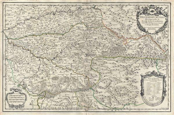
1690 Jaillot Map of Castres Region in Tarn, France
DioceseDeCastres-jaillot-1690$175.00

Title
Diocese de Castres.
1690 (dated) 16.5 x 25 in (41.91 x 63.5 cm) 1 : 220000
1690 (dated) 16.5 x 25 in (41.91 x 63.5 cm) 1 : 220000
Description
This is a fine 1690 map of Castres, located in the department of Tran, France by Alexis Hubert Jaillot. Centered on Brassac, the map covers the region from Albi south as far as Olonzac and from Saint-Sulpic east to Saint-Gervais-sur-Mare. The map renders the entire region in extraordinary detail offering both topographical and political information with mountains and forests beautifully rendered in profile. This area produces a variety of traditional wines, including Cahors, Mauzac, Loin de l'Oeil and Ondenc for the white varieties and Braucol, Duras and Prunelart for the reds. The map renders the entire region in extraordinary detail offering both topographical and political information with mountains and forests beautifully rendered in profile. A decorative title cartouche adorns the upper right quadrant of the map, while another cartouche in the lower right quadrant includes the legend. This map was engraved by Cordier and issued by Jaillot in 1690.
Cartographer
Alexis-Hubert Jaillot (c. 1632 - 1712) followed Nicholas Sanson (1600 - 1667) and his descendants in ushering in the great age of French Cartography in the late 17th and 18th century. The publishing center of the cartographic world gradually transitioned from Amsterdam to Paris following the disastrous inferno that destroyed the preeminent Blaeu firm in 1672. Hubert Jaillot was born in Franche-Comte and trained as a sculptor. When he married the daughter of the Enlumineur de la Reine, Nicholas I Berey (1610 - 1665), he found himself positioned to inherit a lucrative map and print publishing firm. When Nicholas Sanson, the premier French cartographer of the day, died, Jaillot negotiated with his heirs, particularly Guillaume Sanson (1633 - 1703), to republish much of Sanson's work. Though not a cartographer himself, Jaillot's access to the Sanson plates enabled him to publish numerous maps and atlases with only slight modifications and updates to the plates. As a sculptor and an artist, Jaillot's maps were particularly admired for their elaborate and meaningful allegorical cartouches and other decorative elements. Jaillot used his allegorical cartouche work to extol the virtues of the Sun King Louis IV, and his military and political triumphs. These earned him the patronage of the French crown who used his maps in the tutoring of the young Dauphin. In 1686, he was awarded the title of Geographe du Roi, bearing with it significant prestige and the yearly stipend of 600 Livres. Jaillot was one of the last French map makers to acquire this title. Louis XV, after taking the throne, replaced the position with the more prestigious and singular title of Premier Geographe du Roi. Jaillot died in Paris in 1712. His most important work was his 1693 Le Neptune Francois. Jalliot was succeeded by his son, Bernard-Jean-Hyacinthe Jaillot (1673 - 1739), grandson, Bernard-Antoine Jaillot (???? – 1749), and the latter's brother-in-law, Jean Baptiste-Michel Renou de Chauvigné-Jaillot (1710 - 1780). More by this mapmaker...
Condition
Very good. Original platemark visible. Minor wear and verso reinforcement along original centerfold. Damp stains, lower margins with creasing near centerfold, not extending onto printed area. Minor spotting here and there. Blank on verso.