This item has been sold, but you can get on the Waitlist to be notified if another example becomes available, or purchase a digital scan.
1845 Bradford Map of Mississippi / The Surveying District South of Tennessee
DistrictSouthTennessee-bradford-1845$200.00

Title
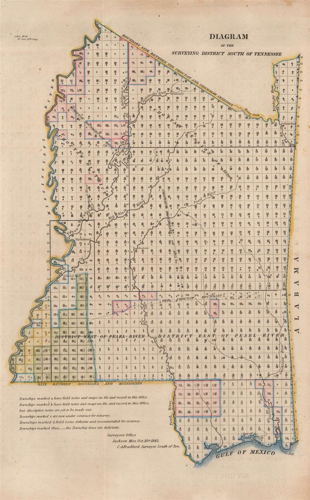
Diagram of the Surveying District South of Tennessee.
1845 (dated) 17 x 11.5 in (43.18 x 29.21 cm) 1 : 1250000
1845 (dated) 17 x 11.5 in (43.18 x 29.21 cm) 1 : 1250000
Description
This is an 1845 Charles A. Bradford map of Mississippi or the Surveying District South of Tennessee with references to the Indian Removal Act and the Trail of Tears. Townships throughout Mississippi are illustrated, with letters marking the current state of surveys. The map notes townships with maps and field notes on file in the Surveyor General's Office, townships that were currently being resurveyed, and townships that were recommended for resurveying. The state's rivers are illustrated and labeled, along with a handful of cities, including Vicksburg and Jackson.
Surveying District South of Tennessee
While the history of the Surveying District South of Tennessee is difficult to piece together, the district was created not long after the Northwest Ordinance was passed in 1787. The first 'Surveyor of the Land South of Tennessee', Isaac Briggs (1763 - 1825), was appointed around April 1, 1803. During this time, that Territory of Mississippi encompassed most of modern-day Mississippi and Alabama, with Georgia forming the eastern border, Tennessee the northern border, the Mississippi River the western border and Louisiana (then the Territory of Orleans) and Spanish Florida the southern border. At that time, the Mississippi Territory did not reach the Gulf of Mexico. The section of land reaching the Gulf of Mexico was annexed to the Mississippi Territory in 1812. Mississippi became a state in 1817, which was when the Alabama Territory was created. It appears that the Surveying District South of Tennessee was not abolished in favor of Surveyor General offices in Mississippi and Alabama until sometime in the 1840s, if not later.A Short Explanation of a Township
The township was created as the measure of the Public Land Survey System, which was first widely implemented to survey the Northwest Ordinance. The Public Land Survey System allowed for the systematic surveying and mapping of any territory gained by the United States. It played a pivotal role in subsequent settlement and administration new territories and states. The work of the survey influenced American Indian removal efforts, town building, railroad grants, new settlement, and more. Moreover, the efforts of the Land Survey were significant in centralizing power with the Federal Government at the expense of states.American Indian Cessions and the Trail of Tears
Following shortly on the events associated with the Trail of Tears and the Indian Removal Act in the late 1830s, this map identifies the seized American Indian lands, with 'Old Choctaw Boundary', 'Choctaw District', 'Choctaw Cession of 1830', 'Choctaw Boundary of 1822', and 'Boundary Line Between the Choctaw and Chickasaw Cessions' all appearing on the map. Between 1830 and 1850, approximately 60,000 Native Americans were forcibly removed from their land in the American Southeast and relocated to Indian Territory (modern-day Oklahoma).Publication History and Census
This map was created under the supervision of Charles A. Bradford, Surveyor General of the Surveying District South of Tennessee and published in a report to the United States Senate in 1845. We note three examples cataloged in OCLC which are part of the collections at the Wisconsin Historical Society, the Birmingham Public Library, and the University of Oregon.Cartographer
Charles A. Bradford (fl. 1845 - c. 1847) was an American newspaper editor and Surveyor General of the Surveying District South of Tennessee. Before being appointed Surveyor General in April 1845, Bradford was the editor of the Pontoctoc Tribune. Very little information survives about Bradford's life and career. More by this mapmaker...
Condition
Very good.
References
OCLC 670232363.