
1831 Baker Map of Dorchester and Milton, Massachusetts

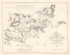
A Map of the Towns of Dorchester and Milton, 1831, Made under the direction of the town's committees for the use of the Commonwealth.
Early Signs of America's Industrialization.
- Digital Map Information
- Suitable for large format printing
- Full resolution TIFF file
- ICC color profile embedded
- Delivered instantly via download link
Early Signs of America's Industrialization.
This is Edmund J. Baker's rare 1831 survey map of Dorchester (now part of Boston) and Milton, Massachusetts, prepared for the Commonwealth's statewide mapping project and recording the towns' developing industrial landscape along the Neponset River. Its combination of named residences, manufacturing sites, turnpikes, and tidal waterways documents two communities whose economic connections extended beyond their municipal boundaries. Particularly notable is the appearance of the recently opened Granite Railway, one of the first railways in the United States, built to carry Quincy granite toward the Bunker Hill Monument.A Closer Look
Oriented with north toward the upper right, the map extends from Dorchester's boundary with Roxbury and South Boston southwest through Milton to the Blue Hills and Houghton's Pond. The Neponset River divides the two towns, winding between wooded uplands before broadening into an estuary fringed with marshes. Dorchester Bay, Commercial Point, Savin Hill, and Thompson's Island occupy the eastern portion.Individual dwellings appear as small squares accompanied by residents' names. Churches and schools are illustrated with symbols, while 'manufactories' and mills are distinguished by cross-shaped marks. Public roads, private ways, and turnpikes have separate line conventions. Distance marks are recorded along the roads, while tables of distance to Boston's Quincy Market and Dedham's courthouse appear above and below the map. Statistical notices also describe the towns' civic institutions and recent population growth, while text near the distance tables discusses their educational and industrial institutions.
Early American Industrialization
The map is notable for recording the emergence of the American Industrial Revolution in New England. The Neponset River corridor is particularly relevant in this regard. Here, cotton manufactories, paper mills, a starch manufactory, wharves, and tidewater appear among the concentrations of houses and roads. The accompanying text inventories Dorchester's cotton and woolen manufacturing, four paper mills, four corn mills, two chocolate mills, and a starch manufactory. Milton's account lists two paper mills and a drug mill. Because the cramped Shawmut Peninsula lacked the rushing water needed to drive machinery, Boston merchants channeled maritime capital into the Neponset corridor, transforming it into a hub for pioneering water-powered enterprises, including early paper manufactories, iron-slitting mills, gunpowder works, and what eventually became the Baker Chocolate Company (later the Walter Baker Chocolate Company) at Milton Lower Mills. This firm was co-founded by Dr. James Baker, whose grandson, Edmund, is our cartographer.The Granite Railway
Near the eastern edge of Milton, a route labeled Railway runs toward the Neponset, with a Railway House beside a road crossing. This is the Granite Railway, chartered on March 4, 1826, and designed by engineer Gridley Bryant to transport stone from Quincy through Milton to the river for onward shipment to the Bunker Hill Monument. Commencing operations on October 7, 1826, the three-mile line did not use steam locomotives; instead, horses hauled cars along wooden rails plated with iron straps, taking advantage of gentle downhill grades to ease the journey toward the water. Beyond moving stone, the railway served as a vital proving ground for pioneering transportation technology. To maneuver the immense weights safely and efficiently, Bryant developed several foundational railroad mechanisms, including early railway switches, turntables, reliable mechanical brakes, and eight-wheeled double-truck cars capable of distributing heavy cargo across multiple axles. After completing its initial task for the Bunker Hill Monument, the line operated successfully for decades, eventually modernizing with steam power after being acquired by the Old Colony Railroad in the 1870s. While rail operations ceased in the 20th century, portions of the right-of-way and the famous granite incline remain preserved today as landmarks of early American industrial engineering.A Local Survey for a Statewide Project
In 1830, the Massachusetts General Court enacted a legislative resolve requiring every town and district in the Commonwealth to conduct a cadastral survey of its territory and submit a detailed map to the Secretary of the Commonwealth. Intended to provide the raw local data needed to produce the first scientifically rigorous master map of the state, the mandate instructed municipalities to record their boundaries, roads, waterways, meetinghouses, schools, mills, and forest cover, largely at their own expense. To stitch these disparate local plans together, the state commissioned a pioneering trigonometric and astronomical survey led by engineer Simeon Borden and astronomer Robert Treat Paine. In practice, relying on hundreds of independent local surveyors yielded wildly uneven results: while some produced sophisticated engineering drafts, others submitted rudimentary sketches warped by magnetic variation and pacing errors—prompting Borden to lament that the gap between two adjacent town maps left enough unaccounted space to drop the entire city of Boston between them. While reconciling the flawed patchwork delayed publication of Borden’s official topographical map until 1844, the surviving 1830 town plans remain an invaluable cartographic record, capturing the Massachusetts landscape in minute detail at the peak of agricultural land clearing and the dawn of the Industrial Revolution.Publication History
The map was made from surveys by Edmund J. Baker under the direction of the towns' committees and lithographed in Boston by Pendleton's Lithography in 1831. OCLC listings co-mingle the 1831 original with an 1889 reproduction by the Photo-Electrotype Co., requiring an examination of individual institutional records, which only reveals one example of the 1831 original at the Norman B. Leventhal Map and Education Center at the Boston Public Library. An example cataloged as 1831 at the Library of Congress is, in fact, the later reproduction ('photocopy' in their record), while the New England Historic Genealogical Society is listed in the OCLC as holding an 1831 example, but their own catalog returns no results for either printing of the map. Harvard catalogs both the 1831 original and the 1889 reproduction, but the scanned image for both maps in the Harvard Map Collection displays the 1889 printing, leaving its status ambiguous. The Dorchester Athenaeum may also hold an example of the 1831 original.Cartographers
Edmund James Baker (November 15, 1804 - January 15, 1890) was an American surveyor, mapmaker, and antiquarian active in Milton and Dorchester, Massachusetts, during the 19th century. Born in Dorchester, he was the son of chocolate manufacturer Edmund Baker (1770 - 1846) and Elizabeth Vose Lillie, and the grandson of Dr. James Baker (1739 - 1825), an early manufacturer of Baker family chocolate. After working in commerce, he studied surveying, while his brother, Colonel Walter Baker (1792–1852), managed the chocolate business (afterWalter's death, it eventually passed to a step-nephew, Henry Lillie Pierce, who expanded it substantially). Edmund Baker's 'A Map of the Towns of Dorchester and Milton' appeared in 1831, lithographed by Pendleton's of Boston from surveys undertaken for the Commonwealth. Baker subsequently prepared numerous property plans for Milton, Dorchester, and neighboring towns; he also laid out roads and lots in Dorchester South Burying Ground during the 1830s. He represented Milton in the Massachusetts General Court in 1837 and served as its postmaster from 1838 to 1842 before returning to Dorchester. On September 1, 1847, he married the widow Sarah Howard Sherman, with whom he had two daughters. Estate administration eventually displaced surveying as his principal occupation. A founder of the Dorchester Antiquarian and Historical Society, he served as its president from 1873 until his death on January 15, 1890. Further Details...
Pendleton's Lithography (1825 – 1836) was an American lithography firm active in Boston during the early 19th century. The firm was founded by brothers John and William S. Pendleton. Little is known of John, but William apparently moved to Boston from Montreal, Canada with Alexander McKenzie, a copper plate engraver. The two set up business with Abel Bowen from about 1820 to 1825. Around this time John Pendleton entered the picture. He and William purchased some lithographic tools from a Boston merchant named only Thaxter, who apparently acquired them in Europe but did not understand their use. The Pendleton's subsequently became the first lithographers in Boston. Their work was respected for portraiture, landscape prints, music covers, and other illustrations. Among William Pendleton's apprentices are the famous 19th century lithographers Benjamin F. Nutting and Nathaniel Currier (of Currier and Ives). John Pendleton retired from the firm in 1828, but it continued to operate under William. William, in turn, sold the firm to his bookkeeper, Thomas Moore, who changed the name but maintained the same business practices. In 1840, Moore sold out to Benjamin W. Thayer. Pendleton's Lithography was based in three separate locations in Boston: Harvard Place (1825-1826), Graphic Court (1826-ca.1832), and finally Washington Street (ca.1836). Further Details...
Condition
Very Good. Faint water stain through Dorecester Bay. Laid down on original linen.
References
Boston Public Library, Norman B. Leventhal Map and Education Center, Call No. G3764.B6:2D6 1831 .B3. Massachusetts Archives, Office of the Secretary of State, Town Plans--1830, SC1 / Series 48X.