
1932 Stiles Pictorial Map of American Expeditionary Force Operations, World War I

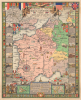

Historical Map American Expeditionary Force showing Battle Lines Base Ports Communications and Allied Zones.
Striking Pictorial Map of U.S. Role in World War I.
- Digital Map Information
- Suitable for large format printing
- Full resolution TIFF file
- ICC color profile embedded
- Delivered instantly via download link
Striking Pictorial Map of U.S. Role in World War I.
This is a 1932 pictorial map of the American Expeditionary Force in World War I (1914 - 1918), drawn by Ezra C. Stiles, himself a veteran of the war, with historical material by Paul C. Bowman. It combines the geography of American operations with the remembered language of soldiering: complaints about food, weather, discipline, and the long wait to go home. Battle lines share the sheet with hospitals, aviation schools, supply railways, divisional insignia, and wartime songs. Published in the Interwar Period, 14 years after the Armistice, the map presents an overseas army through both its military organization and the experiences its veterans shared.A Closer Look
France dominates the central map, with coverage extending from southern England and the Low Countries to western Germany, Switzerland, and northern Italy. Red and green lines mark the farthest German advance and the front at the Armistice of November 11, 1918. Another line identifies part of the Hindenburg defensive system. Arrows mark German attacks in 1914, while hatching marks the territory the Allies occupied after the fighting ended. Flags locate headquarters, including the American command at Chaumont and the Allied headquarters at Châlis, here labeled for General Foch.Major roads, railways, and waterways are traced throughout, with inland training establishments, hospitals, and depots marked along the way. This geography reflects a fundamental logistical constraint; British and French traffic already crowded the northern ports and railways, requiring the Americans to develop Atlantic facilities farther from the front, at places like Saint-Nazaire and Bordeaux. Red crosses mark hospital centers, while roundels distinguish aviation establishments; several are labeled by function, such as replacement barracks at Saint-Maixent and the service depot at Romorantin. Langres is labeled for its Army Schools; for Stiles, this was familiar territory as he served with Army engineers and taught at the Army Engineer School at Langres during the war.
Across the map, scrolls carry the ordinary soldier's voice: 'When Do We Eat', 'And They Call This Sunny France', and 'My Uncle Knows A Congressman' turn the map into a collection of recognizable service experiences. Elementary French phrases recall encounters with civilians, while other illustrations refer to soldiers' unglamorous daily experience. A large compass rose anchors the lower-left portion of France, its radiating lines passing among these expressions.
Beyond the main map, four inset maps cover Paris, the Atlantic journey of U.S. troops, and campaigns in the St. Mihiel Salient and the Meuse-Argonne, two major American engagements. Within the border, illustrated historical panels trace the story from the outbreak of war through American intervention, combat, occupation, and homecoming. Illustrations of ships, tanks, ruined villages, trench raiders, and crowded railway cars appear along with explanatory text. The border includes a procession of insignia for combat divisions, reserve and replacement formations, armies, and corps. At bottom-right, separate panels identify the 369th, 370th, and 372nd Infantry; these African American regiments were assigned to the French as the U.S. Army was segregated at the time.
The American Expeditionary Forces in World War I
Established in 1917 under the command of General John J. Pershing, the American Expeditionary Forces (AEF) were deployed to the Western Front with the strict mandate to operate as an independent army rather than piecemeal reinforcements for depleted British and French divisions. Although initial deployments were slow as millions of 'doughboys' were drafted and trained, fresh American forces reached critical mass in mid-1918, just as both the Allied and Central Powers neared total exhaustion. The AEF proved decisive in blunting Germany's Spring Offensive and spearheading major counteroffensives at Belleau Wood, Saint-Mihiel, and the Meuse-Argonne, tipping the balance of manpower, industrial resources, and battlefield morale decisively in the Allies' favor and hastening the Armistice of November 11, 1918. In the aftermath, the AEF's military contribution established the United States as a primary global power and gave President Woodrow Wilson substantial leverage to shape the post-war order through his Fourteen Points and the creation of the League of Nations, fundamentally altering America's geopolitical role throughout the twentieth century.Publication History
This map was drawn by Ezra C. Stiles, with Paul C. Bowman providing historical information, and was printed by the Herbick and Held Printing Company. Little concrete information is available on Bowman, but he was most likely Paul Clifton Bowman (1900 - 1967), a World War I veteran like Stiles and a prominent Pittsburgh dentist. This map is noted among the holdings of the David Rumsey Historical Map Collection and 6 institutions in the OCLC.Cartographers
Ezra Clarke Stiles (September 26, 1891 - January 27, 1974) was an artist, landscape architect, urban planner, and cartographer, long active in Pittsburgh, Pennsylvania. A descendant of prominent Yale University President Ezra Stiles (1727 - 1795), Stiles the younger was born in Upstate New York and attended Pennsylvania State University, earning a degree in Forestry and Landscape Architecture in 1914. He briefly worked as an urban planner in Charlotte, North Carolina, and then for a landscape architecture firm in Boston before moving to Pittsburgh in 1915 to work for the landscape design firm A.W. Smith. He joined the U.S. Army during the First World War and was assigned to the 44th Depot Detachment of Engineers, performing a variety of functions related to his drafting and drawing skills, eventually teaching at the Army Engineer School at Langres, France. Returning to Pittsburgh after the war, Stiles founded his own firm in 1926 and quickly became celebrated as one of the premier landscape architects working in the city, designing gardens for local grandees, universities, corporations, public parks, and others. He even designed two complete parks for Pittsburgh's centennial as well as the McKeesport Rose Garden and Arboretum, and later in his career worked to expand the Allegheny County Park System. Stiles wrote three books on landscape architecture and drew four pictorial maps during his career, the latter including a map of Frick Park in Pittsburgh, a birds-eye view of Pittsburgh in 1939, a related historical view of Pittsburgh in 1889 (the two were reprinted together in a smaller format in Fortune magazine), and, in conjunction with historian Paul Bowman, an historical map of the American Expeditionary Forces in World War I. Further Details...
Herbick and Held Printing Company (1903 - 1988) was an American commercial printing firm based in Pittsburgh, Pennsylvania, whose 20th-century production included historical maps, books, periodicals, and corporate publications. Founded in 1903 by Nicholas Herbick and August Held (1861 - 1943), a German immigrant, the business subsequently operated under Held and his son Bert after Herbick's retirement in 1919. Contemporary advertisements identify its premises at the Point Building, Penn Avenue and Water Street, in 1920, and at 1116 - 1136 Brown Street on Pittsburgh's North Side in 1922, when it offered trade presswork, large-edition book work, and publication printing. Later company personnel rosters place it at 1117 Wolfendale Street. After another printing firm acquired it in 1984, Herbick and Held closed in 1988. Further Details...
Condition
Excellent. Mounted on poster linen.
References
Rumsey, 15810.000. OCLC 701830198.