This item has been sold, but you can get on the Waitlist to be notified if another example becomes available, or purchase a digital scan.
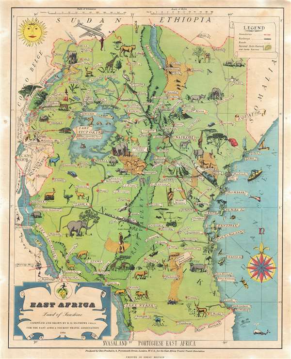
1954 Mathews Pictorial Map of East Africa (Kenya, Tanzania, Uganda, Zanzibar)
EastAfrica-mathews-1954$150.00

Title
East Africa. Land of Sunshine.
1954 (dated) 14 x 11 in (35.56 x 27.94 cm) 1 : 6500000
1954 (dated) 14 x 11 in (35.56 x 27.94 cm) 1 : 6500000
Description
This is a rare 1954 Dennis Owen Mathews pictorial map of East Africa, including modern day Kenya, Tanzania, Zanzibar, and Uganda. Centered on the Rift Valley, which is colored in a darker green, the map covers from Lake Tanganyika to the Indian Ocean and from the Sudan/Ethiopia border to Ruvuma River. The map is clearly intended to promote East African tourism and give the impression of a playground of wonderful exotic beasts well-connected by a comprehensive transportation network.
The map identifies many of East Africa's great game parks, including the Serengeti, Tsavo, Ngorongoro, Marsabit, and Selous, among others. Noted as well is Lake Victoira, along with its supposed lake monster, Lukwata. Throughout the great beasts of the East African's plains, elephants, lions, rhinos, giraffes, buffalo, zebras, and antelopes abound. Moreover, much of the regional transport network is illustrated. The road network, complete with 1930s style automobiles, winds its way between cities and Nature Pakrs. It also illustrates several early African railroads, including routes from Nairobi and Arusha (Mout Kilimanjaro) to Mobasa and Tanga, and the Kigoma – Dar es Salaam Route.
This map was drawn by Dennis Owen Mathews, a Fellow of the Royal Geographical Society and general manager of the East Africa Tourist Travel Association and printed by Glen Freebairn of London. There are at least two editions, a large format edition issued in 1949, and the present smaller variant, issued with some updates, such as removing the Ground Nut Scheme lands, in 1954. It is rare to the market in all editions.
Cartographer
Dennis Owen Mathews (February 21, 1901 - 197?) was an English army officer, artist, cartographer, and travel-industry businessman active in the early to middle 20th century. Mathews was born in London and educated at Latymer School, London and Varndean School, Brighton. He joined the Royal Air Force in 1918, towards the end of World War I. After the war he was assigned to the Uganda Survey Department, Royal Engineers, where he served from 1921 to 1946. In 1948 he became the General Manager of the East African Tourist Travel Association, a position which he held until 1963. He was the United Nations Tourism Expert in 1965 and the Director of Tourism of the Seychelles from 1965 to 1966. Later he became the General Manager of Downey and Selby Safaris from 1967 to 1970. During his service as General Manager of the East African Tourist Travel Association, he drew and published several pictorial maps of different parts of East Africa. His works includes maps of Kenya, Tanzania, Uganda, Gedi, and Kampala. He was a Fellow of the Royal Geographical Society, was recognized in 1959 as an Officer of the Most Excellent Order of the British Empire (OBE), and in 1965 as a Knight of the Most Distinguished Order of Saint Michael and Saint George. He was also an avid big game hunter. In the world of cartography, Mathews is significant as one of the few pictorial cartographers to produce maps focused on African topics. More by this mapmaker...
Condition
Very good. Even overall toning. Light wear along original fold lines. Verso repairs to fold separations. Text and printed images on verso.
References
OCLC 902603930.