
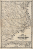
1863 Colton Civil War Map of Eastern North Carolina showing Union Blockade

This item has been sold.
Colton's New Topographical Map of the Eastern Portion of the State of North Carolina with Part of Virginia and South Carolina from the latest and best authorities.
Blockade Runners on the Carolina Coast.
- Digital Map Information
- Suitable for large format printing
- File Size: 81.37 MB
- File Type: ZIP / TIFF
- ICC color profile embedded
- Delivered instantly via download link
Blockade Runners on the Carolina Coast.
This is J. H. Colton's rare, large-format 1863 map of the eastern part of North Carolina during the American Civil War. Among other features, it highlights the Union blockade of the coastlines of these Confederate states, a somewhat porous but still important factor in constraining the Southern economy throughout the war.A Closer Look
This stunning map covers from Virginia and the entrance of the Chesapeake Bay to South Carolina, focusing on the eastern part of North Carolina and the Outer Banks. 18 ships illustrate the Union blockade of the North Carolina coast. The topography throughout is beautifully detailed with rail lines, towns, swamps, political boundaries, and more identified. Along the bottom of the sheet, a secondary map, 'Plan of the Sea Coast from Virginia to Florida,' offers an overall picture of the Atlantic seaboard during the war. The identifier 'No. 11' appears in the upper left corner, suggesting that this map may have been part of a series intended to illustrate the events of the Civil War. We have identified a more common but similar map Colton's Topographical Map of the Seat of War in Virginia, Maryland … as part of the same series.The Anaconda Plan, Strangling the South
The Union blockade of the southern coastline was a key part of General Winfield Scott's 'Anaconda Plan,' designed to strangle the Confederate economy by severing its international trade. In southern Virginia and the Carolinas, this strategy was particularly high stakes due to the presence of critical rail hubs and the proximity to the Confederate capital in Richmond. Below the Chesapeake, the focus centered on the North Carolina Sounds and the port of Wilmington, North Carolina, which became the South's most vital lifeline as other ports fell over the course of the war. To counter the blockade, the Confederacy was forced to rely on 'blockade runners,' sleek, fast steamers designed to slip through the Union cordon under cover of darkness.The geography of the Carolinas provided a natural advantage for these runners. The jagged coastline, filled with inlets, sandbars, and shallow sounds like the Pamlico and Albemarle, made it difficult for heavy Union warships to maneuver or pursue. Wilmington, North Carolina, protected by the formidable Fort Fisher at the mouth of the Cape Fear River, remained the 'Gibraltar of the South' until the final months of the war. However, relying on blockade runners came with its own dangers, as when a sick crew of such a vessel caused a devastating yellow fever outbreak in Wilmington in 1862.
By 1864, while the Union blockade had successfully slashed southern exports of cotton and imports of essential salt and machinery, the flow of munitions through Wilmington kept Robert E. Lee's Army of Northern Virginia in the field. The eventual fall of Fort Fisher in January 1865 effectively closed the last major door to the outside world, signaling the logistical collapse of the Confederacy.
Publication History and Census
There were several issues of this map. Our example, printed by Lang and Cooper, bears a copyright of 1860 and an issue date of 1863 under the cartouche. Another version, printed by Lang and Laing, a predecessor of Lang and Cooper, appears with an 1861 copyright date and an 1862 date under the cartouche. Rumsey suggests that this map was first issued in 1861, despite the 1860 copyright, and was last issued in 1864, although we have found no examples of that edition. Today, this map is exceedingly rare outside of institutional collections.Cartographers
Joseph Hutchins Colton (July 5, 1800 - July 29, 1893), often publishing as J. H. Colton, was an important American map and atlas publisher active from 1833 to 1897. Colton's firm arose from humble beginnings when he moved to New York in 1831 and befriended the established engraver, Samuel Stiles. He worked under Stiles as the 'Co.' in Stiles and Co. from 1833 to 1836. Colton quickly recognized an emerging market in railroad maps and immigrant guides. Not a cartographer or engraver himself, Colton's initial business practice mostly involved purchasing the copyrights of other cartographers, most notably David H. Burr, and reissuing them with updated engraving and border work. His first maps, produced in 1833, were based on earlier Burr maps and depicted New York State and New York City. Between 1833 and 1855, Colton proceeded to publish a large corpus of guidebooks and railroad maps, which proved popular. In the early 1850s, Colton brought his two sons, George Woolworth Colton (1827 - 1901) and Charles B. Colton (1832 - 1916), into the map business. G. W. Colton, trained as a cartographer and engraver, was particularly inspired by the idea of creating a large and detailed world atlas to compete with established European firms for the U.S. market. In 1855, G.W. Colton issued volume one of the impressive two-volume Colton's Atlas of the World. Volume two followed a year later. Possibly because of the expense of purchasing a two-volume atlas set, the sales of the Atlas of the World did not meet Colton's expectations, and so, in 1856, the firm also issued the atlas as a single volume. The maps contained in this superb work were all original engravings, and most bear an 1855 copyright. All of the maps were surrounded by an attractive spiral motif border that would become a hallmark of Colton's atlas maps well into the 1880s. In 1857, the slightly smaller Colton's General Atlas replaced the Atlas of the World. Most early editions of the General Atlas published from 1857 to 1859 do not have the trademark Colton spiral border, which was removed to allow the maps to fit into a smaller format volume. Their customers must have missed the border because it was reinstated in 1860 and remained in all subsequent publications of the atlas. There were also darker times ahead; in 1858, Colton was commissioned at a sum of 25,000 USD by the government of Bolivia to produce and deliver 10,000 copies of a large format map of that country. Although Colton completed the contract in good faith, delivering the maps at his own expense, he was never paid by Bolivia, which was at the time in the midst of a series of national revolutions. Colton would spend the remainder of his days fighting with the Bolivian and Peruvian governments over this payment, and in the end, after a congressional intervention, he received as much as 100,000 USD in compensation. Nonetheless, at the time, it was a disastrous blow. J. H. Colton and Company is listed as one of New York's failed companies in the postal record of 1859. This led Colton into the arms of Alvin Jewett Johnson and Ross C. Browning. The 1859 edition of Colton's General Atlas lists Johnson and Browning as the 'Successor's to J. H. Colton' suggesting an outright buyout, but given that both companies continued to publish separately, the reality is likely more complex. Whatever the case may have been, this arrangement gave Johnson and Browning access to many of Colton's map plates and gave birth to Johnson's New Illustrated (Steel Plate) Family Atlas. The Johnson's Atlas was published parallel to Colton's atlases well into the 1880s. The Colton firm itself subsequently published several other atlases including an Atlas of America, the Illustrated Cabinet Atlas, the Octavo Atlas of the Union, and Colton's Quarto Atlas of the World. They also published a large corpus of wall maps, pocket maps, and guides. The last known publications of the Colton firm date to 1897 and include a map and a view, both issued in association with the Merchant's Association of New York. Alice M. Colton married August R. Ohman (May 3, 1859 - April 22, 1934) on January 5, 1897. In 1898, Ohman joined the Colton firm, which continued to publish as Colton, Ohman & Co. until 1901. Further Details...
Lang and Cooper (fl. August 16, 1862 - May 2, 1864) were a New York City based engravers and printers active in the middle part of the 19th century. The firm was founded by William Lang and Henry Pooley Cooper. The firm came into being following the dissolution of Lang and Laing where in Cooper took the place of Joseph Laing. In May 1864, Cooper bought out Lang's shares and subsequently published under his own imprint, H. P. Cooper. They specialized in transferring copper and steel plates to lithographic stone for more economical printing. Among others, the firm worked with J.H. Colton and J. Disturnell. Further Details...
Condition
Very good. Light wear and toning along original fold lines. Slight loss at a few fold intersections. Infill to upper right corner effecting border.
References
Rumsey 3044.000. OCLC 227479838, 5484311.