This item has been sold, but you can get on the Waitlist to be notified if another example becomes available, or purchase a digital scan.
1929 Tyng Pictorial Map of the Eastern United States
EasternUnitedStates-tyng-1929$750.00

Title
Map of the Eastern United States.
1929 (dated) 34.25 x 25 in (86.995 x 63.5 cm) 1 : 3600000
1929 (dated) 34.25 x 25 in (86.995 x 63.5 cm) 1 : 3600000
Description
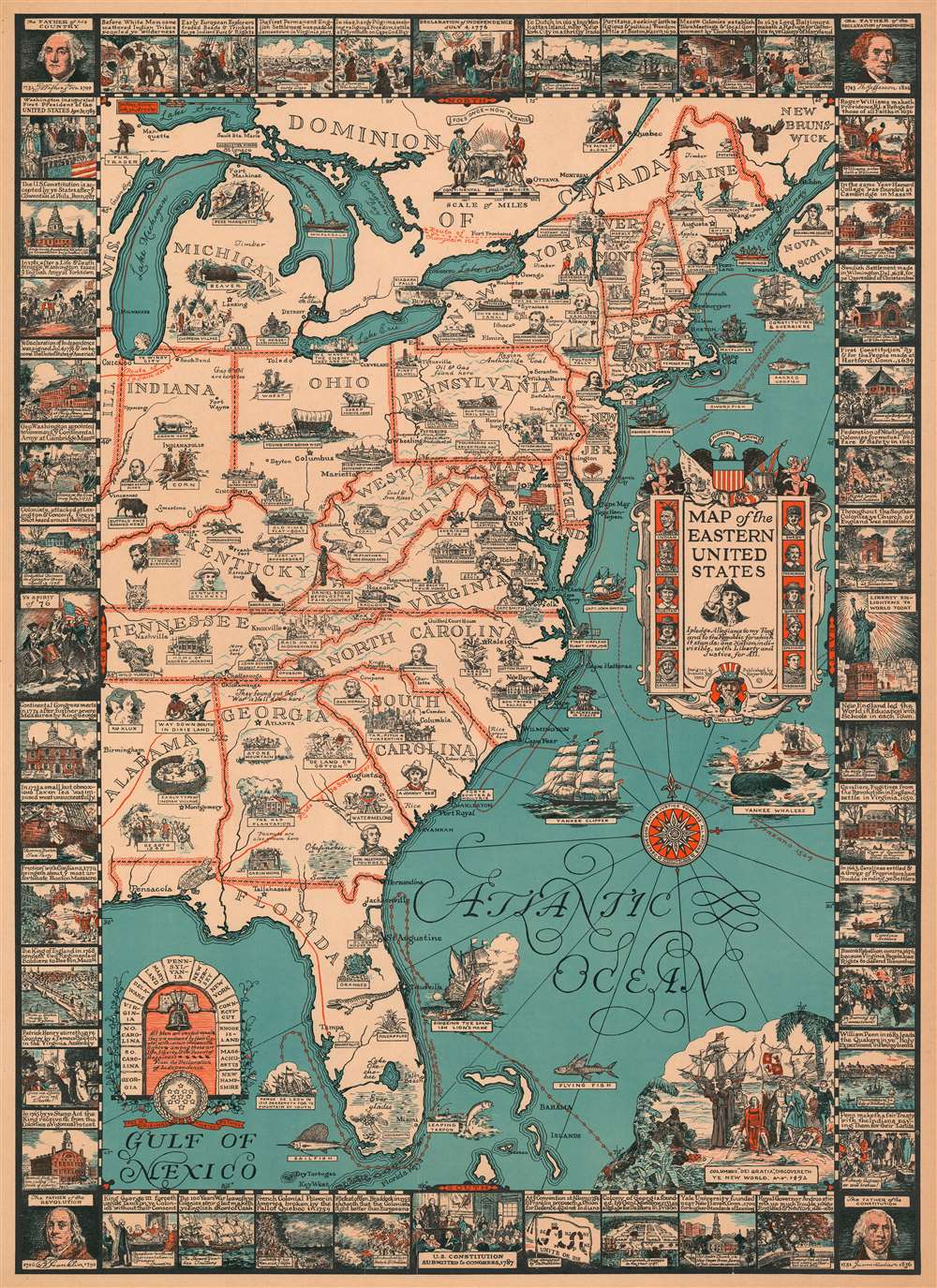
This is a 1929 Griswold Tyng pictorial map of the eastern United States highlighting important events and figures in American history. Pictorial vignettes scattered throughout identify these moments and people, sometimes explicitly, while others necessitate a certain level of familiarity with the subject. For instance, the portraits presented here refer back to not only the founding of the colonies but the exploration of the continent, with La Salle illustrated in Michigan and the routes of La Salle, Champlain, Ponce de Leon, de Soto, and Verrazano traced across the continent and the seaboard. Other portraits include American presidents, among these Theodore Roosevelt and Abraham Lincoln; writers, such as James Fenimore Cooper and Henry Wadsworth Longfellow; and reminders of less exultant parts of the country's past, including the Ku Klux Klan, ' Johnny Reb', and Jefferson Davis, the President of the Confederacy.
Historical events, such as the Surrender at Appomattox Court House that ended the American Civil War, President Lincoln's Gettysburg Address, and the horrible winter suffered by the Continental Army at Valley Forge are also referenced. American industry makes an appearance, with references made to ship building, whaling, and iron smelting. Agricultural pursuits are also highlighted. Wheat and sheet are included in Ohio, while cotton and tobacco adorn North Carolina, and oranges and grapefruit populate Florida. The whole is surrounded by a pictorial summary of American colonial history, from before the arrival of the first European settlers until George Washington's inauguration as the First President of the United States in 1789. Portraits of Washington, Thomas Jefferson, James Madison, and Benjamin Franklin adorn the corners.
Historical events, such as the Surrender at Appomattox Court House that ended the American Civil War, President Lincoln's Gettysburg Address, and the horrible winter suffered by the Continental Army at Valley Forge are also referenced. American industry makes an appearance, with references made to ship building, whaling, and iron smelting. Agricultural pursuits are also highlighted. Wheat and sheet are included in Ohio, while cotton and tobacco adorn North Carolina, and oranges and grapefruit populate Florida. The whole is surrounded by a pictorial summary of American colonial history, from before the arrival of the first European settlers until George Washington's inauguration as the First President of the United States in 1789. Portraits of Washington, Thomas Jefferson, James Madison, and Benjamin Franklin adorn the corners.
Publication History and Census
This map was designed by Griswold Tyng and published by Harper Brothers in 1929. Six examples are catalogued in the OCLC as being part of the institutional collections at the Buffalo and Erie County Public Library, the Wisconsin Historical Society, Stanford University as part of the David Rumsey Map Collection, Trinity College Library in Dublin, the National Library of Scotland, and the British Library. We have found no other occurrences when this map has appeared on the private market in recent years.Cartographer
Griswold Tyng (August 13, 1883 - March 6, 1962) was an American painter and illustrator active in Massachusetts. Tyng was born in Dorchester, Massachusetts to Elizabeth (Walworth) and Stephen H. Tyng. He studied art under Joseph De Camp and Howard Pyle at the Massachusetts Normal Art School (now the Massachusetts College of Art and Design). Tyng worked for many years as an illustrator for the Boston Planning Board. He also produced several pictorial maps and illustrated many books, especially children's books, while also pursuing more 'serious' artistic work, especially landscape paintings. Cartographically he is responsible for at least three maps, a 1928 pictorial map of New England, a 1929 pictorial map of the East Coast of the United States, and a c. 1930 pictorial map of Boston Common. Tyng married Clara Margaret Fuller, known as Margaret, on June 10, 1912, with whom he had two children. Tyng was killed outside his home after being hit by a car while crossing the street after mailing a letter. More by this mapmaker...
Condition
Average. Even overall toning. Closed tears extending 6.5 inches and 4 inches into printed area from bottom margin and two tears each extending 2 inches into printed area from top margin professionally repaired on verso. Closed margin tears professionally repaired on verso. Blank on verso.
References
Rumsey 8725.000. OCLC 810481160.