This item has been sold, but you can get on the Waitlist to be notified if another example becomes available, or purchase a digital scan.
1846 Walker Map of Proposed East Indian Railway Calcutta - Delhi, India
EastIndianRailway-walker-1846$1,750.00

Title
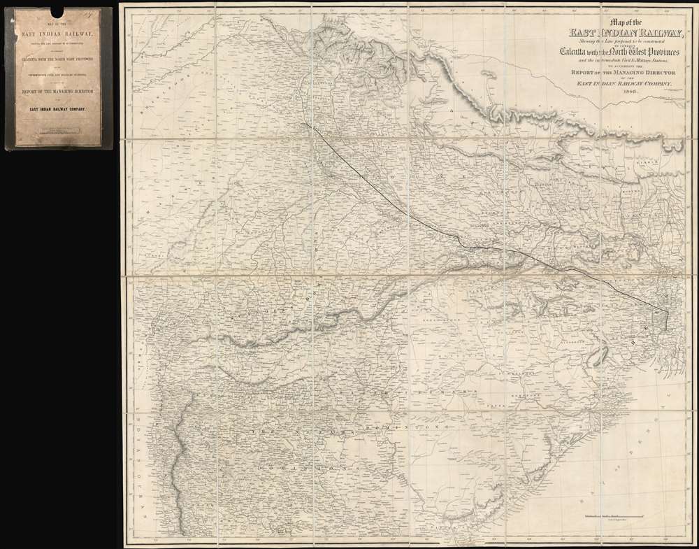
Map of the East Indian Railway, Shewing the Line proposed to be constructed to connect Calcutta with the North West Provinces and the intermediate Civil and Military Stations, to Accompany the Report of th Managing Director of the East Indian Railway Company. 1846.
1846 (dated) 44 x 47 in (111.76 x 119.38 cm) 1 : 1527778
1846 (dated) 44 x 47 in (111.76 x 119.38 cm) 1 : 1527778
Description
In all likelihood, the first railroad map of any part of India. Illustrating a transformative moment in the infrastructure development of India, this is rare and important 1846 John and Charles Walker map northeastern India, defining the course of one of India's first passenger railroads. Published one year after the East India Railroad Company (EIR) was founded, this map was intended to raise funds and political support for their flagship initiative, a passenger and freight railroad connecting the port of Calcutta, then the economic capital of India, with the inland administrative center of Delhi. This is, in short, one of the most significant and influential maps relating to the early planning of the Indian railroad system ever published.
East Indian Railway
The East Indian Railway was the brainchild of Rowland MacDonald Stephenson (1808 - 1895). Until the 1845 rail transport in India was limited to short distance industrial lines, but Stephenson imagined a great network of passenger trains running throughout the subcontinent. Stephenson published an 1844 article in a popular daily, The Englishman, proposing a broad network of passenger railroads throughout India that, he argued, were ideally planned to be most advantageous to the subcontinent. The proposal achieved some initial funding and in 1845, Stephenson, along with three assistants, traveled to India and 'with diligence and discretion' surveyed, statistically studied, and costed the potential traffic for a railway route from Calcutta to Delhi via Mirzapur. They assessed that the maximum cost of a twin-track line at roughly £15000 per mile.The Railroad Begins
Stephenson returned to England, where he was able to secure the support of the East India Company and additional financing. There he also commissioned the firm of J. and C. Walker to compile a large map, the present offering, illustrating his survey work and bold plans for the Calcutta - Delhi line. Using the map to lure additional investment, Stephenson secured the permission to raise £4,000,000. Although raising the necessary funds took several years, the EIR was contracted by the East India Company to begin railway construction until 1849 when it became one of the three companies (The East India Railway, the Madras Railway, and the Great Indian Peninsular Railway) sanctioned to construct experimental lines. The EIR opened its first section. from Howrah to Hooghly in 1854. The East India Railway reached Delhi until 1864, becoming one of the first major railroad lines in India, and the first to connect these distant cities.Publication History and Census
This was engraved and printed by John and Charles Walker (J. and C. Walker) on behalf of the East Indian Railway Company. Examples are extremely rare. We have identified copies at the British Library, the University of Minnesota, and the National Library of Scotland. No previous history on the private market.Cartographer
John Walker (1787 - April 19, 1873) was a British map seller, engraver, lithographer, hydrographer, geographer, draughtsman, and publisher active in London during the 19th century. Walker published both nautical charts and geographical maps. His nautical work is particularly distinguished as he was an official hydrographer for the British East India Company, a position, incidentally, also held by his father of the same name. Walker's maps, mostly published after 1827, were primarily produced with his brothers Charles Walker and Alexander Walker under the imprint J. and C. Walker. Among their joint projects are more than 200 maps for the influential Society for the Diffusion of Useful Knowledge Atlas (SDUK). In addition they published numerous charts for James Horsburgh and the British Admiralty Hydrographic Office, including Belcher's important map of Hong Kong and Carless' exploratory map of Karachi. The J. and C. Walker firm continued to publish after both Walkers died in the 1870s. More by this mapmaker...
Condition
Very good. Dissected and mounted on linen. Original binder.
References
OCLC 49933067.