This item has been sold, but you can get on the Waitlist to be notified if another example becomes available, or purchase a digital scan.
1712 Wells Map of India and the East Indies
EastIndies-wells-1712$550.00

Title
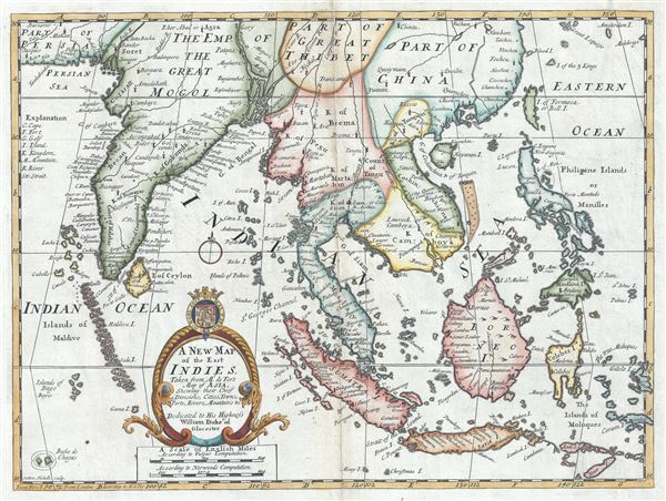
A New Map of the East Indies, Taken from Mr. de Fer's Map of Asia, Shewing their Chief Divisions, Cities, Towns, Ports, Rivers, Mountains etc.
1712 (undated) 15 x 19.5 in (38.1 x 49.53 cm) 1 : 13000000
1712 (undated) 15 x 19.5 in (38.1 x 49.53 cm) 1 : 13000000
Description
This is an attractive and scarce 1712 map of India and the East Indies by Edward Wells of Oxford. Centered on Malaysia, this beautiful map covers all of Southeast Asia from Persia to the Timor Island, inclusive of the modern day nations of India, Ceylon, Thailand, Burma (Myanmar), Malaysia, Cambodia, Vietnam, Laos, Indonesia, Borneo, and the Philippines. Based on Nicholas De Fer's map of Asia, the map renders the region in detail offering both topographical and political information with mountains beautifully rendered in profile. The Island of Singapore is shown but not labeled. Bali (Baly) and Lombok (Lombock) as well as Batavia are identified. Most of the Great Sunda Islands as well as the Lesser Sunda Islands, which were largely unexplored well into the 19th century, are mapped speculatively. Depicts a fairly narrow India and a misshaped Taiwan.
A large title cartouche is included in the bottom of the map featuring the coat of arms of the Duke of Gloucester. This, like many other Wells maps, is dedicated to Prince William, Duke of Gloucester and son of Queen Anne, who, when this map was being prepared, was a student at Oxford. Engraved by Sutton Nicholls and published by T. Bonwicke for the 1712 edition of Edward Wells' Atlas, A New Sett of Maps both of Ancient and Present Geography.
A large title cartouche is included in the bottom of the map featuring the coat of arms of the Duke of Gloucester. This, like many other Wells maps, is dedicated to Prince William, Duke of Gloucester and son of Queen Anne, who, when this map was being prepared, was a student at Oxford. Engraved by Sutton Nicholls and published by T. Bonwicke for the 1712 edition of Edward Wells' Atlas, A New Sett of Maps both of Ancient and Present Geography.
Cartographer
Edward Wells (1667 - 1727) was an English mathematician, geographer, and classical scholar based at Christ Church College, Oxford. Wells trained for the ministry but quickly found himself unsuited to religious life and instead applied for an academic position at Oxford, where he authored numerous well respected works on a wide range of mathematical and scientific topics. He tutored Prince William, the sickly son of Queen Anne, who was likely about 11 at the time this map was prepared. Wells dedicated nearly all of the maps in his atlas, A New Sett of Maps both of Ancient and Present Geography, to the young prince - quite possibly posthumously, as William died in July of 1700 shortly prior to the publication of the atlas. Nonetheless, Wells' geography proved popular and was published in number editions well into the 1730s. More by this mapmaker...
Source
Wells, E., A New Sett of Maps both of Ancient and Present Geography, (London, T. w. Bonwicke) c. 1712.
A New Sett of Maps both of Ancient and Present Geography was published by Edward Wells in various editions between 1701 and 1730. The publication contained some 40 maps all of which were dedicated to Prince William, Duke of Gloucester. Wells tutored the young prince at Christchurch, Oxford and seems to have developed a close relationship with him. At just 11 years of age, William died in 1700 and never had the opportunity to see the published work that he inspired. The atlas was intended for educational purposes with a focus on school use.
Condition
Very good. Some wear and foxing along original centerfold. Original platemark visible. Professionally flattened and backed with archival tissue.
References
New York Public Library, Map Division, OCLC : 7143148 (1700 edition).