This item has been sold, but you can get on the Waitlist to be notified if another example becomes available, or purchase a digital scan.
1935 Jan Wijga Pictorial Map of the East Indies KNILM Airlines Routes
EastIndiesKNILM-wijga-1935$1,250.00

Title
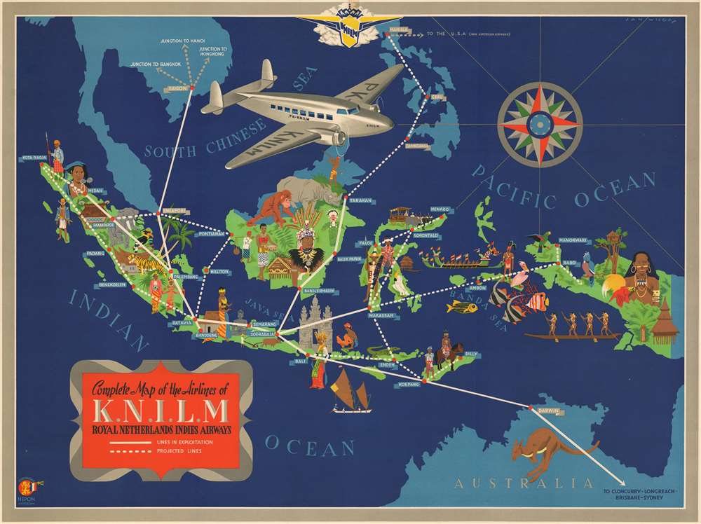
Complete Map of the Airlines of K.N.I.L.M., Royal Netherlands Indies Airways.
1935 (undated) 22.75 x 30.5 in (57.785 x 77.47 cm) 1 : 6280000
1935 (undated) 22.75 x 30.5 in (57.785 x 77.47 cm) 1 : 6280000
Description
A striking c. 1935 art deco map of the East India archipelago and parts of Southeast Asia drawn by Dutch commercial artist Jan Wijga for KNILM, or the Royal Netherlands Indies Airways (1928 - 1942). The map covers from Bangkok to Darwin, Australia, and from Sumatra to New Guinea. The former Dutch East Indies, modern day Indonesia, are highlighted with vivid coloration and vignette illustrations of the indigenous people, architecture, and wildlife. Solid lines indicate the airlines extant routes, while dotted lines illustrate proposed routes - including the KNILM's planned amphibious routes to the rural eastern islands of the archipelago. The plane in the image is the Lockheed Model 14 Super Electra, more commonly known as the Lockheed 14, the 14 passenger star of the KNILM fleet.
KNILM
Koninklijke Nederlandsch-Indische Luchtvaart Maatschappij, or KNILM, (Royal Dutch Indies Airways) was the airline of the former Dutch East Indies. The airline was founded in 1928 by Netherlandish-Indian investors. Service focused on the Dutch East Indies, modern day Indonesia, but later expanded to Southeast Asia, Asia, and Australia. During World War II, KNILM's planes were used to evacuate and transport troops. The final KNILM flight took off on March 7, 1942, one day before Java capitulated to the Japanese. A few KNILM planes managed to escape to Australia, but most were destroyed by the Japanese. After the war, the remaining aircraft were auctioned to the American government and KNILM formally disbanded. Groundside assets were sold to KLM and created the core of KLM Interinsulair Bedrijf (interinsular service), today's Garuda Indonesia Air.Publication History and Census
This map was designed by Jan Wijga, published by NEPON, and commissioned by KNILM. Although unattributed, it was most likely printed by J. A. Luli and Company of Amsterdam - as was most of Wijga's other work. The map is undated, but based upon the air-routes depicted, we can assume an approximate date of 1935. Only one state is known. All examples are exceedingly rare, with the only identifiable surviving examples being at the Wolfsonian-Florida International University, and at the Universiteitsbibliotheek Leiden.Cartographer
Jan Wijga (December 13, 1902 - December 10, 1978), aka Wyga, was a Dutch Art Deco painter, designer, and illustrator active in Holland in the middle part of the 20th century. Wijga worked extensively for KNILM (Royal Dutch Indies Airways) and various beer companies, producing posters and other highly graphic promotional material. We are aware of only 3 cartographic images by Wijga, a map of KNILM routes, a smaller but similar map focusing on Bali/Lombok, and an ethnographic game-map of the world. Wijga's work is typically considered in the context of with other European commercial artists who rose to prominence during the interwar period, including Lucien Boucher, Otto Arpke, Jean Carlu, Paul Colin, and Albert Solon, among others. Their work took advantage of advancements in color printing made before and during World War I (1914 - 1918) to issue stunning large format maps with large intense solid color blocks and eye-popping graphics. More by this mapmaker...
Condition
Very good. Minor repair upper left corner margin.
References
OCLC 1016673339. The Wolfsonian-Florida International University, TD1990.335.15.