This item has been sold, but you can get on the Waitlist to be notified if another example becomes available, or purchase a digital scan.
1859 Kraetzer Real Estate Promotional Map of East New York, Brooklyn
EastNewYork-kraetzer-1859$475.00


Title
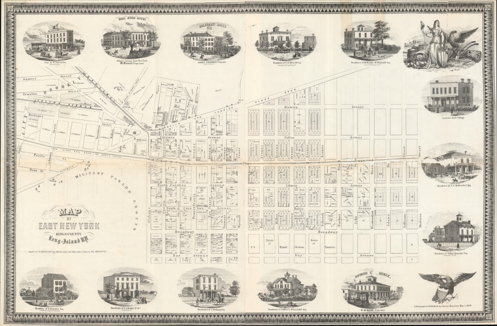
Map of East New York Kings County Long-Island NY.
1859 (dated) 22.25 x 34 in (56.515 x 86.36 cm)
1859 (dated) 22.25 x 34 in (56.515 x 86.36 cm)
Description
This is the only known surviving example of an 1859 real-estate promotional map for East New York, Brooklyn, published by Charles W. Heitkamp. The map, printed and published by residents, captures the moment of East New York's transition from an agricultural community on the outskirts of Brooklyn to a German-American suburb well connected to major public transportation arteries.
The map is surrounded by vignette illustrations of prominent East New York properties, including the homes of W. Simison (Fulton), John Lohman (Liberty), C. R. Miller (Vansiclen), Bernard McWilliams (Hull), J. C. Middendorf's shop and home, William Alexander (Flatbush), Howard House (P. H. Reid Proprietor; Atlantic), James S. William, Heitkamp's shop and home (East New York), C. A. Beckert's shop and home (Sheffield), and the printer himself, Gustov Kraetzer (Sheffield). Several of these vignettes illustrate the rather humble L.I.R.R. running on Atlantic. Overall, the images present the prosperous homes and businesses of professionals, mostly of German descent, many bearing the honorific 'Esquire' (not intended to represent a lawyer, as is common today, but rather any educated professional).
A Closer Look
The map covers what is today East New York in the vicinity of Broadway Junction, extending roughly from Bay Avenue to Division Avenue and east from modern-day Eastern Parkway to Madison Street. It is a cadastral map illustrating specific lots and property owners, including the publisher Heitkamp's home and business on the Brooklyn and Jamaica Plank Road (paved with wooden planks, now East New York Avenue) between Georgia and Sheffield. The map notes the Long Island Railroad running along Atlantic Avenue and the Broadway Horsecar Rail Line, which connected Williamsburg to the L.I.R.R. at East New York Junction. This connection was inaugurated in 1859 and is likely the inspiration for this map, as Heitkamp, George D. Pitkin, M. G. Johnson, and other East New York real estate pioneers sought to capitalize on their holdings.The map is surrounded by vignette illustrations of prominent East New York properties, including the homes of W. Simison (Fulton), John Lohman (Liberty), C. R. Miller (Vansiclen), Bernard McWilliams (Hull), J. C. Middendorf's shop and home, William Alexander (Flatbush), Howard House (P. H. Reid Proprietor; Atlantic), James S. William, Heitkamp's shop and home (East New York), C. A. Beckert's shop and home (Sheffield), and the printer himself, Gustov Kraetzer (Sheffield). Several of these vignettes illustrate the rather humble L.I.R.R. running on Atlantic. Overall, the images present the prosperous homes and businesses of professionals, mostly of German descent, many bearing the honorific 'Esquire' (not intended to represent a lawyer, as is common today, but rather any educated professional).
East New York
The area illustrated here, today part of East New York, was a prosperous farming community until the 1840s, when real estate investors like George D. Pitken began purchasing and lotting out the property for sale. They recognized the area's potential as a nexus of two major public transportation systems: the Broadway Horsecar Rail Line and the Long Island Railroad. It initially prospered, drawing skilled professionals of German, Jewish, and Slavic descent. The neighborhood was hit hard by the closing of Bushwick's breweries during Prohibition, the Great Depression, and the exodus of manufacturing work from New York after World War II (1939 - 1945). The area was subsequently settled by Puerto Ricans and African-Americans, who emigrated to New York City from points south expecting ready employment and a better life. East New York, no longer replete with the jobs the new residents hoped for, fell into despair under a host of socioeconomic problems, including widespread unemployment and crime. Today, the area has been rezoned and is undergoing widespread urban renewal and gentrification.Publication History and Census
This map is based on surveys and maps by M. G. Johnson. It was compiled and published by Charles Wilhelm Heitkamp and printed in 1859 by Gustav Kraetzer, both East New York residents with homes on this map. The western quarter of the map, including the title, was used on a broadside promoting a real estate auction at the Merchants' Exchange on May 18, 1859 - we note three institutional holdings. Of this, the original map, we are aware of no other surviving examples - although we do see a photo-facsimile at the Brooklyn Historical Society.CartographerS
Ludwig Gustav Adolph Kraetzer (March 21, 1822 - October 21, 1901), generally publishing as Gustav Kraetzer, was a German-American lithographer and printer based in New York. Kraetzer was born in Mainz, Rheinland-Pfalz, Germany. He was involved with the Revolutions of 1848 and following the suppression was forced to flee Germany. He arrived in the United States, coming through New York, in October of 1850 on the ship William Tell. He became a U.S. citizen several years later in 1856. When Kraetzer arrived in New York it has already a master lithographer, having trained in Germany. His printing concern was widely published and includes decorative prints, views, business products, advertising, and maps. Kraetzer maintained offices on Sheffield Avenue in East New York, Long Island, now part of Brooklyn. More by this mapmaker...
Charles Wilhelm Heitkamp (March 21, 1822 - June 1, 1875) was a German-American merchant, lawyer, and real estate investor based in East New York, Brooklyn, in the mid to late 19th century. Heitkamp was born in Alzey, Alzey-Worms, Rhineland-Palatinate, Germany. He was an early settler and promoter of that portion of New Lots, Brooklyn, that is now known as East New York. It is not clear when he emigrated to the Untied States, but he was likely a 48er - one of the multitude of educated Germans that fled the Fatherland in the wake of the failed 1848-49 Springtime of the Peoples Revolutions. Learn More...
Condition
Average. Some paper reinstatement and infill to center horizontal fold, and here and there elsewhere. Old tape stains. Laid down on archival tissue. Loss to 'Middendorf' vingette, right center. Several sheets joined.