This item has been sold, but you can get on the Waitlist to be notified if another example becomes available, or purchase a digital scan.
1681 Du Val Map of The Canal du Mudi (Canal Royal en Languedoc), France
EauxMontagneNoire-duval-1681$175.00

Title
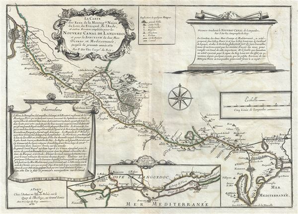
La Carte des Eaux de la Montagne Noire, du Lers, du Fresquel, de l'Aude, et autres Rivieres emploiees pour le Nouveau Canal de Languedoc et pour la Ionction des deux Mers Oceane, et Mediterranee, jusqu'a la presente annee 1681.
1681 (dated) 13.5 x 18.5 in (34.29 x 46.99 cm) 1 : 300000
1681 (dated) 13.5 x 18.5 in (34.29 x 46.99 cm) 1 : 300000
Description
This is a scarce 1681 Pierre Du Val map of the Canal du Mudi or the Canal Royal en Languedoc. It covers from the Mediterranean and Etang-de Bages-Sigean westward to Toulouse. The map was drawn to show the waters of the Montagne Noire, the Fresquel, Aude and other rivers used for the Royal Canal in Languedoc. It renders the entire region in extraordinary detail, noting towns and cities along the canal and rivers, with mountains and forests beautifully rendered in profile.
The Canal royal en Languedoc, as it was originally called, was proposed by Pierre-Paul Riquet in 1662 and ran from Toulouse to the Sete. Construction on the canal began in 1666. Primarily meant for the transportation of wheat from Toulouse and other goods (including wine), the canal would not only save time, but also provide safe passage for goods by avoiding the pirates of the Gibraltar Strait. The 'Canal Royal en Languedoc' was renamed 'Canal du Mudi' in 1789 during the French Revolution. Considered to be one of the greatest constructions of the 17th century, the Canal du Mudi was included in the list of World Heritage Sites in 1996.
A short paragraph containg 'Observations' is included in the bottom left quadrant, and another note in included in the top right quadrant. An inset of the coast of Languedoc is featured along the bottom border. A beautiful title cartouche adorns the top left ight quadrant of the map. This map was created by Pierre Du Val in 1681.
Condition
Very good. Minor wear along original centerfold. Original platemark visible. Some offsetting.