This item has been sold, but you can get on the Waitlist to be notified if another example becomes available, or purchase a digital scan.
1834 S.D.U.K. Map of Edinburgh, Scotland
Edinburgh-sduk-1834$75.00

Title
Edinburgh.
1834 (dated) 12.5 x 15.5 in (31.75 x 39.37 cm) 5.944444444
1834 (dated) 12.5 x 15.5 in (31.75 x 39.37 cm) 5.944444444
Description
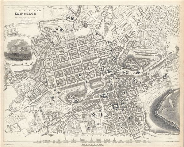
This is a beautiful 1834 map or plan of the city of Edinburgh, Scotland by the Society for the Diffusion of Useful Knowledge. Centered on Old Town, it covers the city of Edinburgh, known as the 'Athens of the North' in exceptional detail, noting individual streets, buildings, rivers, squares and parks. A beautiful illustration of Edinburgh Castle is included along the left border, below the title. The lower border depicts the many important monuments and buildings in profile. These include the Observatory, the Old High School, St. Giles's Church, St. John's Chapel, Assembly Rooms, Colton Jail, etc.
In the 19th century, Edinburgh was the heart of the Scottish enlightenment. Celebrities from across the continent would be seen in the city streets, among them famous Scots such as David Hume, Walter Scott, Robert Adam, David Wilkie, Robert Burns, James Hutton and Adam Smith. Edinburgh became a major cultural center, earning it the nickname Athens of the North because of the Greco-Roman style of the New Town's architecture, as well as the rise of the Scottish intellectual elite who were increasingly leading both Scottish and European intellectual thought. During this time, Edinburgh, like most of Scotland, benefited enormously from the Industrial Revolution.
This map is based on a larger map by Messrs. Laing and Forbes and is printed by J. Henshall. The map is engraved by E. Turrell and Published by Baldwin and Cradock for the Society for the Diffusion of Useful Knowledge in 1840. Although the Society closed its doors in 1848, Subsequent reissues of the S.D.U.K. atlas were printed well into the 1870s by Chapman and Hall, who acquired the original plates.
Cartographer
The "Society for the Diffusion of Useful Knowledge" (1826 - 1848) was a Whiggish organization founded in 1828 at the instigation of idealistic British lord Henry Peter Brougham. The admirable goal of the Society was to distribute useful information via a series of publications to the English working and middle classes. It promoted self-education and the egalitarian sharing of all knowledge. While closely tied to the London University and publishing houses on the order of Baldwin and Cradock, Chapman and Hall, and Charles Knight, the Society failed to achieve its many lofty goals in finally closed its doors in 1848. Most likely the failure of the Society resulted from its publications being too expensive for its intended lower to middle class markets and yet not large and fine enough to appeal to the aristocratic market. Nonetheless, it did manage to publish several extraordinary atlases of impressive detail and sophistication. Their most prominent atlas consisted of some 200 separately issued maps initially published by Baldwin and Cradock and sold by subscription from 1829 to 1844. Afterwards, the Society combined the maps into a single world atlas published under the Chapman and Hall imprint. In its day, this atlas was unprecedented in its quality, scope, and cost effectiveness. Today Society, or S.D.U.K. as it is commonly known, maps are among the most impressive examples of mid-19th century English mass market cartographic publishing available. The S.D.U.K. is especially known for its beautiful and accurately detailed city plans. More by this mapmaker...
Condition
Very good. Blank on verso.
References
Rumsey 0890.174.