
This item below is out of stock, but another example (left) is available. To view the available item, click "Details."
Details
1827 Finley Map of Egypt
1827 (undated) $175.00
1827 Finley Map of Egypt
Egypt2-finley-1827$87.50

Title
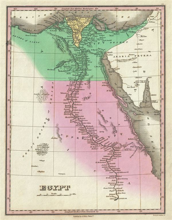
Egypt.
1827 (undated) 12 x 9 in (30.48 x 22.86 cm) 1 : 3400000
1827 (undated) 12 x 9 in (30.48 x 22.86 cm) 1 : 3400000
Description
This is a beautiful example of Finley's important 1827 map of Egypt. It depicts Egypt, centered on the Nile River, and extending south as far as Aswan and names numerous settlements and villages along the course of the river, including a number of temples and ancient Egyptian ruins. Also identifies several desert Oases including Parva (Kharga?) and Shekh Huled (Dakhla?). In the Sinai Peninsula, a mountain labeled 'Gebel Tour, Mt. Sinai or Horeb' is drawn. This map was drawn shortly following the expulsion of the Napoleonic forces from Egypt by the Ottoman Mamluk Turks. Muhammad Ali, the Ottoman commander who was named viceroy of Egypt established the Mamluk dynasty that would rule Egypt until the Egyptian Revolution of 1952. Between 1820 and 1833, Ali annexed northern Sudan, Syria and parts of Arabia into the Mamluk Empire. The map is engraved by Young and Delleker for the 1827 edition of Anthony Finley's General Atlas.
Cartographer
Anthony Finley (August 25, 1784 - June 9, 1836) was an American book and map publisher based in Philadelphia, Pennsylvania. Finley was born in Philadelphia in 1784. He opened a bookshop and publishing house at the Northeast corner of Fourth and Chestnut Street, Philadelphia in 1809. His earliest known catalog, listing botanical, medical and other scientific works, appeared in 1811. His first maps, engraved for Daniel Edward Clarke’s Travels in Various Countries of Europe, Asia, and Africa also appear in 1811. His first atlas, the Atlas Classica, was published in 1818. He soon thereafter published the more significant A New American Atlas and the New General Atlas…, both going through several editions from 1824 to 1834. Although most of Finley's cartographic material was borrowed from European sources, his atlases were much admired and favorably reviewed. In addition to his work as a printer, Finley ran unsuccessfully on the 1818 Democratic ticket for Philadelphia Common Council. He was a founding officer of the Philadelphia Apprentices’ Library, and a member of both the American Sunday-School Union and the Franklin Institute. He was also an ardent supporter of the American Colonization Society, an organization dedication to returning free people of color to Africa - which led to the founding of Liberia. Much of his wealth was dedicated to supporting this cause. Finley was active as a publisher until his 1836 death, apparently of a 'lingering illness.' Shortly thereafter advertisements began appearing for his map business and plates, most of which were acquired by Samuel Augustus Mitchell. More by this mapmaker...
Source
Finley, A., A New General Atlas, Comprising a Complete Set of Maps, representing the Grand Divisions of the Globe, Together with the several Empires, Kingdoms and States in the World; Compiled from the Best Authorities, and corrected by the Most Recent Discoveries, Philadelphia, 1827.
Condition
Very good. Overall age toning. Minor spotting. Original platemark visible.
References
Rumsey 0285.059 (1831 edition). Phillips (Atlases) 4314, 760, 752, 6045.