This item has been sold, but you can get on the Waitlist to be notified if another example becomes available, or purchase a digital scan.
1829 Lapie Map of Egypt from Nubia, Abyssinia, Kordofan
EgyptNubie-lapie-1829$100.00

Title
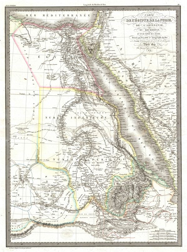
Carte de l'Egypte de la Nubie, de l'Abissinie, du Kourdofan.
1829 (dated) 22 x 16 in (55.88 x 40.64 cm)
1829 (dated) 22 x 16 in (55.88 x 40.64 cm)
Description
A fine first edition example of M. Lapie's 1829 map of egypt. The map covers the lower Nile valley including egypt and Nubia, as well as the adjacent Arabian Gulf or Red Sea, Mediterranean Sea, Arabia, Kordofan, Sudan, Abyssinia, Darfur, and Sennar. Lapie drew this map shortly following the expulsion of the Napoleonic forces from egypt by the Ottoman Mamluk Turks. Muhammad Ali, the Ottoman commander who was was named viceroy of egypt established the Mamluk dynasty that would rule egypt until the egyptian Revolution of 1952. Between 1820 and 1833, Ali annexed northern Sudan, Syria and parts of Arabia into the Mamluk empire.
This map was engraved by Armand Joseph Lallemand as plate no. 40 in the first edition of M. Lapie's important Atlas Universel. This map, like all maps from the Atlas Universel features an embossed stamp from the Lapie firm.
This map was engraved by Armand Joseph Lallemand as plate no. 40 in the first edition of M. Lapie's important Atlas Universel. This map, like all maps from the Atlas Universel features an embossed stamp from the Lapie firm.
CartographerS
Pierre M. Lapie (fl. 1779 - 1850) and his son Alexandre Emile Lapie (fl. 1809 - 1850) were French cartographers and engravers active in the early part of the 19th century. The Lapies were commissioned officers in the French army holding the ranks of Colonel and Capitan, respectively. Alexander enjoyed the title of "First Geographer to the King", and this title appears on several of his atlases. Both father and son were exceptional engravers and fastidious cartographers. Working separately and jointly they published four important atlases, an 1811 Atlas of the French Empire (Alexander), the 1812 Atlas Classique et Universel (Pierre), the Atlas Universel de Geographie Ancienne et Modern (joint issue), and the 1848 Atlas Militaire (Alexander). They also issued many smaller maps and independent issues. All of these are products of exceptional beauty and detail. Despite producing many beautiful maps and atlases, the work of the Lapie family remains largely underappreciated by most modern collectors and map historians. The later 19th century cartographer A. H. Dufour claimed to be a student of Lapie, though it is unclear if he was referring to the father or the son. The work of the Lapie firm, with its precise engraving and informational density, strongly influenced the mid-19th century German commercial map publishers whose maps would eventually dominate the continental market. More by this mapmaker...
Armand Joseph Lallemand (c. 1810 - 1871) was an engraver and map publisher based in Paris during the mid-19th century. Most of Lallemand's work focused on landscapes and building vies, though he did take part in a few cartographic ventures, including the production of an atlas with Alexandre Emile Lapie and several tourist pocket maps of Paris. Learn More...
Source
Lapie, M., Atlas Universel de Geographie. Ancienne et Moderne, precede d'un Abrege de Geographic Physique et Historique…, 1829. (Rumsey identifies this as the first edition of Lapie's Atlas Universel. In all known examples, the title page is dated 1829 while the maps are dated variously to 1833 - suggesting that the first issue of this atlas was 1833, not 1829.)
Condition
Very good. Original platemark visible. Blank on verso. Original centerfold.
References
Rumsey 2174.040. Phillips (Atlases) 754, 765.