This item has been sold, but you can get on the Waitlist to be notified if another example becomes available, or purchase a digital scan.
1871 Meyer and Wonneberg Wall Cadastral Map of Elizabeth, New Jersey
Elizabeth-meyerwonneberg-1871$2,750.00


Title
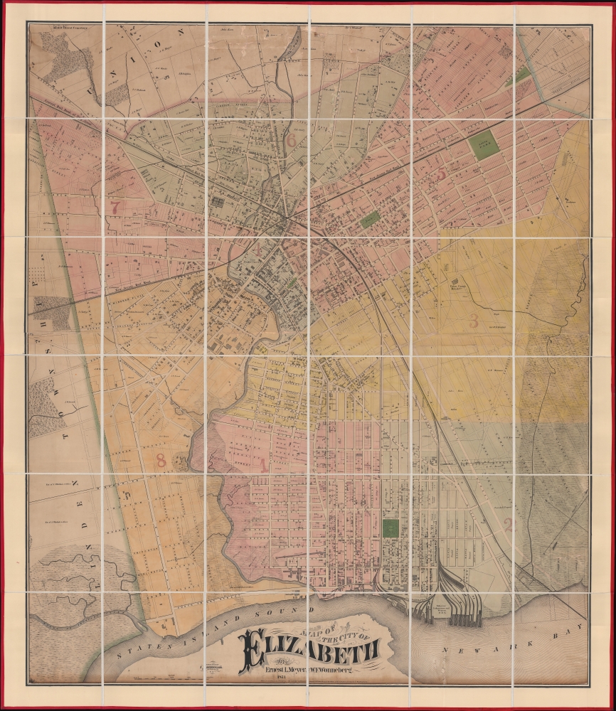
Map of the City of Elizabeth.
1871 (dated) 52 x 44.5 in (132.08 x 113.03 cm) 1 : 4800
1871 (dated) 52 x 44.5 in (132.08 x 113.03 cm) 1 : 4800
Description
This is a previously uncatalogued 1871 Ernest L. Meyer and W. F. Wonneberg cadastral wall map of Elizabeth, New Jersey. This map is a unique record of the urban expansion of Elizabeth through the late 19th century.
A Closer Look
Coverage embraces from Mount Olivet Cemetery to Staten Island Sound and Newark Bay and from Linden Township to Woodruff's Creek, Meyer and Wonneberg. Dashed lines and faint lettering mark streets outside the historical town center, illustrating the rapid urbanization. These 'ghost' streets cut through larger tracts of land owned by individuals, or marshes or swamps that have been reclaimed. Other 'ghost' streets cut through parts of the city closer to the center of town, illustrating the city's expanding grid. Innumerable buildings appear throughout town, many of which are identified by the owner's last name or by their use. Among these are factories, businesses, and churches. The New Jersey Rail Road and the Central Rail Road of New Jersey cut through town and intersect near Broad Street and Morris Avenue. Wharves operated by the railroads, which include the Central Rail Road of New Jersey and the Delaware, Lakawanna and Western Railroad Company, appear on the shores of Newark Bay, ready to unload their cargo.Then and Now
Most of the streets illustrated here still exist in Elizabeth today, including some of those 'ghosted' in on the right. The southernmost boundary of Newark Airport runs along North Avenue, with the southernmost reaches of the airport near the intersection of North Avenue and Division Street (which appears on this map). However, land use has drastically changed over time, and the street grid on the right does not appear today as exactly it does here.Publication History and Census
This map was created and published by Ernest L. Meyer and W.F. Wonneberg in 1871 and engraved by Joseph Shedler. It does not appear in OCLC or the Library of Congress.CartographerS
Ernest Ludolph Meyer (August 26, 1828 - April 3, 1902) was a German American civil engineer, surveyor, and mapmaker. Born in Horneburg, Lower Saxony, Germany, Meyer arrived in the United States in 1851. Meyer served as City Surveyor of Elizabeth, New Jersey, for nearly thirty-five years. He planned Elizabeth's entire sewer system and devised the changes abolishing crossings at Elizabeth by the Pennsylvania and New Jersey Central railroads. Meyer's maps were recognized for their 'historical accuracy'. Meyer also designed Evergreen Cemetery in Elizabeth. More by this mapmaker...
Joseph Schedler (April 22 1813 - December 12, 1887) was a New York based engraver, printer, lithographer, and globe maker active from about 1850 to at least 1889. Schedler was born in Germany and immigrated to the United States, a Forty-Eighter fleeing the German Revolutions of 1848-1849. He was active from at least 1850 when he partnered with fellow German immigrant, the landscape artist, painter, and engraver, Theodore August Liebler (1830 – 18??), to found the lithography firm of Schedler and Liebler, 129 William Street. The firm completed engraving work for J. H. Colton as early as 1852 but probably dissolved by 1854. Schedler filed a patent in 1878 for a crystallotype machine, a device the employed electrotyping to print textured crystalline surfaces. He is best known today as a globe maker. Joseph Schedler's globes won prizes at the Paris International Exhibition in 1867, the American Institute Fair in 1869 and the Vienna International Exhibition in 1873. From at least 1876 records suggest he relocated to Jersey City, New Jersey. Schedler's son, Herman, was also a globe maker, and inherited his father's business sometime around 1877, producing globes will to about 1901. Learn More...
Condition
Good. Full professional restoration. Cracking and loss at top center. Trimmed into image with border reinstated.