This item has been sold, but you can get on the Waitlist to be notified if another example becomes available, or purchase a digital scan.
1859 Dufour Map of the Empire of Alexander the Great
EmpireAlexandre-dufour-1860$112.50

Title
Empire d'Alexandre.
1860 (dated) 23 x 31 in (58.42 x 78.74 cm) 1 : 7000000
1860 (dated) 23 x 31 in (58.42 x 78.74 cm) 1 : 7000000
Description
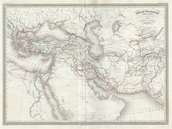
This is an extremely attractive and uncommon large 1860 elephant folio map of the Empire of Alexander the Great by A. H. Dufour. The map covers from Alexander's homeland in Macedonia eastwards past Asia Minor and Persia as far as India and south to include Egypt. Both the Caspian Sea and the Black Sea are included. Throughout, the map identifies various cities, towns, rivers and assortment of additional topographical details.
Dufour created this map to illustrate the conquests of the Macedonian King Alexander III, called ‘the Great,' conqueror of the Persian empire and at just thirty, ruler of one of the largest Empires in history. Alexander the Great was undefeated in battle and is considered one of the most successful military commanders of all time. The map also notes the route for the march of Alexander, inland through Gedrosia. Alexander lost a huge number of soldiers and supplies during this march through the desert.
This map was prepared by Auguste-Henri Dufour and engraved by Charles Dyonette for publication plate no. 3 in Armand Le Chevalier's 1860 edition of Atlas Universel, Physique, Historique et Politique de Geographie Ancienne et Moderne.
CartographerS
Adolphe Hippolyte Dufour (1795 - 1865), also known as Auguste-Henri Dufour, was a Paris based map and atlas publisher active in the middle to late 19th century. Dufour claimed to be a student of another French cartographer, Emile Lapie. He is known to have worked with numerous other French cartographers, publishers, and engravers of the period including Andriveau-Goujon, Charles Dyonnet, and Duvotenay. His corpus includes numerous maps and atlases, the most striking of which is probably his monumental elephant folio Atlas Universel Physique, Historique et Politique Geographie Ancienne et Moderne. Dufour's student and successor was Alexandre Vuillemin. More by this mapmaker...
Charles Dyonnet (fl. c. 1822 - c. 1880) was an extremely active Paris based engraver working in the mid to late 19th century. From his offices at 220 Rue St. Jacques, Paris, Dyonnet engraved numerous maps for many of the most prominent 19th French cartographic publishers including Vuillemin, Dufour, Fremin and Duvotenay. From 1850-1861, he held the coveted position of "Graveur du Dépot de la Marine," and in this position engraved numerous French naval and military maps. Dyonnet had a detail oriented and aesthetically minded hand and is responsible from some of the most beautiful French maps to emerge during the 19th century. Learn More...
Source
Chevalier, A., Atlas Universel, Physique, Historique et Politique de Geographie Ancienne et Moderne, Paris 1860.
The 19th century French cartographer Auguste-Henri Dufour began publishing the dramatic elephant folio Atlas Universel, also occasionally titled Grand Atlas Universal, around 1855. Several editions appeared between its initial publication in the 1850s and a final run c. 1870. The 1863 and 1864 editions in particular are highly desirable among collectors because the United States and North America maps illustrate the proposed, but unrealized, state of Corona (roughly modern day Utah). The atlas contained roughly 40 maps, most of which were engraved by Louis Antoine (the maps) and Deletre (typography) under the supervision of Charles Dyonnet, official engraver of the Depot de la Marine. The Atlas Universal was published in Paris and edited by the firm of 'Paulin et le Chevalier,' 60 Rue Richelieu.
Condition
Very good. Minor wear along original fold lines. Minor spotting at places.
References
Rumsey 5020.006.