This item has been sold, but you can get on the Waitlist to be notified if another example becomes available, or purchase a digital scan.
1892 Kiepert Wall Map of the Ottoman Empire
EmpireOttoman-kiepert-1892$1,250.00


Title
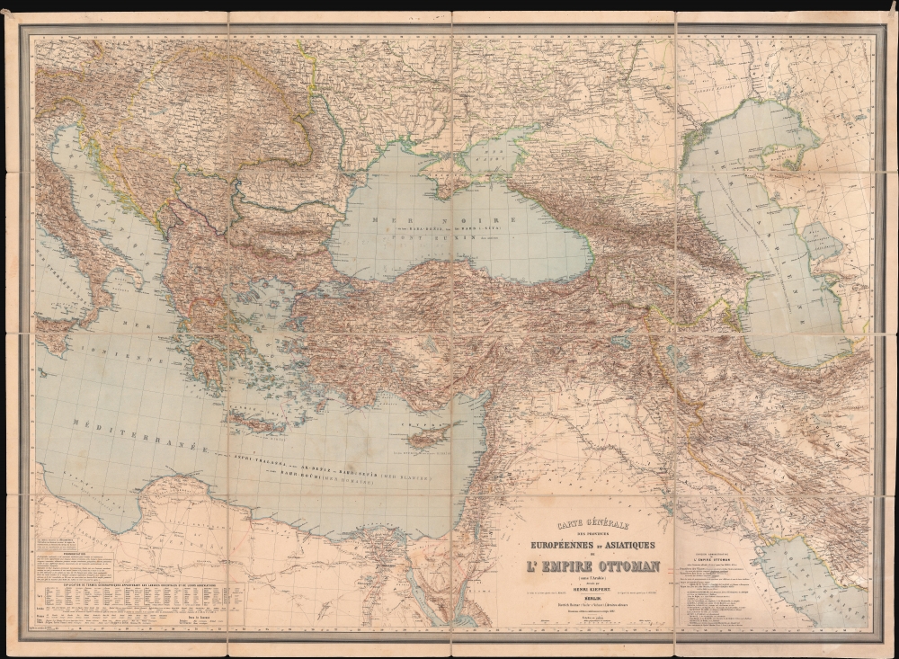
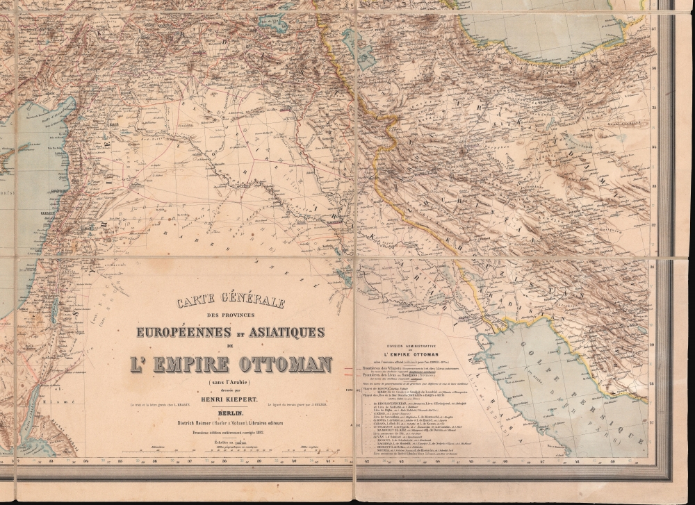
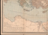
Carte Générale des Provinces Européennes et Asiatiques de l'Empire Ottoman (sans l'Arabie).
1892 (dated) 37 x 51 in (93.98 x 129.54 cm) 1 : 3000000
1892 (dated) 37 x 51 in (93.98 x 129.54 cm) 1 : 3000000
Description
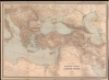
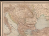
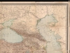
This is an 1892 Heinrich Kiepert wall map of the Ottoman Empire. The work of Europe's finest cartographer, this is without question the best large scale general map of the Ottoman dominions to appear in the 19th century.
A Closer Look
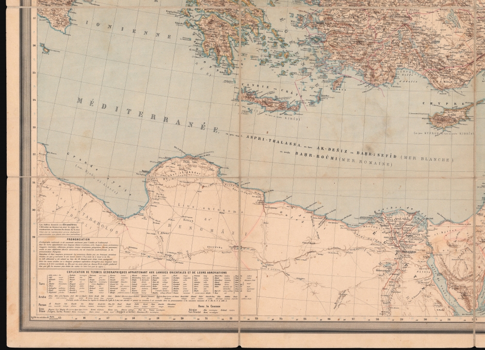
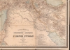
Centered roughly on modern day Ankara, coverage extends from Rome east to the Caspian Sea, Tehran, and the Persian Gulf, including all of the Balkans, the Black Sea, Anatolia, and the Middle East (with the exception of Arabia); and north Africa as far west as Misrata, Libya. The Bosporus, Strait of Marmara, and the Suez Canal (Canal des deux mers) are illustrated. A table in the lower right details the administrative divisions within the Ottoman Empire. Another table, in the lower left, translates Turkish, Persian, Arabic, and Greek, and Slavic geographic terminology into French.Crises in the Balkans and the Ottoman Empire
Kiepert produced this map to capitalize on wider European interest in a region wracked with instability and war. From the 16th through 20th centuries, multiple Russo-Turkish Wars pit the declining Ottoman hegemony against nascent Russia. Larger war led to a host of lesser conflicts and independence movements throughout the Balkans. Between the 1820s and the 1890s, the Ottomans faced uprisings in Greece, Romania, Serbia, Montenegro, Bulgaria, and Bosnia and Herzegovina. By the late 19th century much of the Balkan region had gained either partial autonomy or outright independence. Sensing weakness, western European powers, including Austria-Hungary, France, Great Britain, and Germany gobbled up ill-defended territory: Austria-Hungary occupied Bosnia and Herzegovina, and Great Britain acquired Cyprus.Publication History and Census
This map was created and published by Heinrich Kiepert in Berlin in 1892. Longitude and latitude lines, as well as the lettering, were engraved by Leopold Kraatz. The topography was engraved by J. Sulzer. The present example bears a paste down on the verso from the 'Librairie S. H. Weiss' in Constantinople, which was apparently just across the street from the Russian Consulate. Per a citation in the 1892 edition of the Beliner Titeldrucke, this map represents the fourth editions of Kiepert's Carte Générale de l'Empire Ottoman en Europe et en Asie and the second 'fully corrected' edition. At least one further edition was published posthumously in 1902. Ten examples of the present edition are cataloged in OCLC across two entries and are part of the institutional collections at the University of Chicago, the University of California Berkeley, the Bibliothèque nationale de France, and the Library University of Amsterdam.CartographerS
Heinrich Kiepert (July 31, 1818 - April 21, 1899) was a German cartographer and historian active in the mid to late 19th century. Kiepert was born into generous circumstances that allowed him to develop his childhood interest in geography and history into a serious profession. The Berlin-born Kiepert traveled widely in his youth, and was encouraged in his studies by the historian Leopold von Ranke, a family friend. He was a student of classical antiquity under August Meineke and worked with Cal Ritter. He studied history, philology, and geography at the Humboldt University of Berlin - he would eventually teach geography there, and would remain there until his death. Disappointed with the poor quality of maps in historical school books, Kiepert set out to correct the problem. His first major work, the Atlas von Hellas und den hellenischen Kolonien, was published with Karl Ritter in 1840. The work immediately won accolades from the academic community. A number of similar publications followed, including the 1848 Historisch-geographischer Atlas der alten Welt, the 1854 Atlas Antiquus, and the 1894 Formae Orbis Antiqui. Kiepert specialized in the historical geography of the classical world at the University of Berlin. This developed into a geographical interest in the Ottoman Empire - which at the time was poorly mapped. He traveled to Asia Minor four times between 1841 and 1848, using his travels to collect and compile geographical data, producing several outstanding regional maps with wide-ranging coverage extending from the Mediterranean to the Caucasus. Thanks in large part to these works, Kiepert became the recognized expert on Ottoman geography, his works representing the best obtainable reconnaissances of their respective regions. From 1845 until 1852, Kiepert served as the head of the Geographisches Institut in Weimar. In 1854 he took a position as professor of Geography at the University of Berlin and for nearly 50 years was considered the go-to man with regard to the cartography of classical and biblical antiquity. Kipert formed a long-lasting professional association with Dietrich Reimer, a publisher in Berlin. Kiepert's maps are known for b being clear, easy to read, and as accurate as possible for the time in which they were produced. In addition to his landmark work in mapping the Ottoman Empire, Kiepert also published the first detailed ethnic maps of Austria-Hungary, the Balkan Peninsula, and Germany. Kiepert died in Berlin on April 21 of 1899. More by this mapmaker...
Leopold Kraatz (18xx - 19xx) was a German lithographer, engraver, and printer active in Berlin Germany during the late 19th and early 20th centuries. Kraatz worked with Lange in 1854 and Kiepert from 1860 until 1888. Learn More...
J. Sulzer (18xx - 18xx) was a German engraver active in Berlin during the 19th century and early 20th century. He engraved numerous works for Heinrich Kiepert. Learn More...
Condition
Very good. Dissected and mounted on linen in sixteen panels. Minor soiling.
References
OCLC 21854544; 952147735.