1815 John Cary Folding Case Map of England and Wales
EnglandWales-cary-1815$550.00

Title
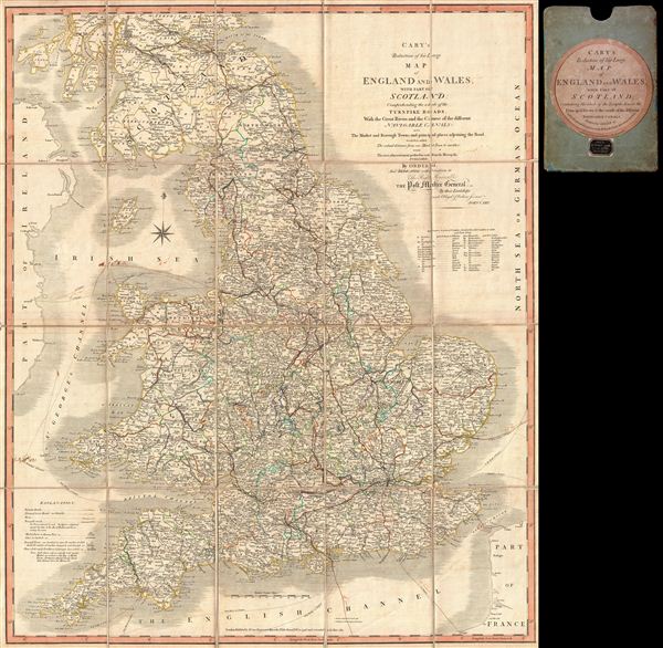
Cary’s Reduction of his Large Map of England and Wales, with part of Scotland; Comprehending the whole of the Turnpike Roads, With the Great Rivers and the Course of the different Navigable Canals: also The Market and Borough Town, and principal places adjoining the Road. To which is added, the Actual distance from one Market Town to another, with The exact admeasurement prefixed to each from the Metropolis. Published by Order of, and Dedicated with Permission to The Right Honorable the Post Masters General, by their Lordships, much Obliged & Obedient Servant, John Cary.
1815 (dated) 30 x 24 in (76.2 x 60.96 cm)
1815 (dated) 30 x 24 in (76.2 x 60.96 cm)
Description
A fine example of John Cary's 1815 map of england and Wales. The map covers all of england and Wales as well as parts of Scotland. Cary identifies all towns and roads, noting mileage between most destinations. First issued in 1796, this map was one of the finest and most popular portable maps of the country available and consequently enjoyed considerably popularity and an over 50 year run. The present example was updated in 1815. Later editions, published after Cary's death, bear the Cruchley imprint.
Unlike most antique maps, this map has an interesting and known provenance. It was used by the American politician Samuel Atkins eliot (1798 - 1862) on his 1821 european tour. At various points in his career, eliot, a Whig, served in the Massachusetts Senate, was the Mayor of Boston, and represented Massachusetts in the United States House of Representatives. eliot traveled to europe on the classic 'Grand Tour' in 1821. Sailing from Boston, he landed at the port of Liverpool, where he acquired this map at the shop of W. Robinson, Castle Street. He traveled throughout england and Scotland, where no doubt this map came in handy as his route is marked in pen, before embarking for the continent several months later.
Unlike most antique maps, this map has an interesting and known provenance. It was used by the American politician Samuel Atkins eliot (1798 - 1862) on his 1821 european tour. At various points in his career, eliot, a Whig, served in the Massachusetts Senate, was the Mayor of Boston, and represented Massachusetts in the United States House of Representatives. eliot traveled to europe on the classic 'Grand Tour' in 1821. Sailing from Boston, he landed at the port of Liverpool, where he acquired this map at the shop of W. Robinson, Castle Street. He traveled throughout england and Scotland, where no doubt this map came in handy as his route is marked in pen, before embarking for the continent several months later.
Cartographer
John Cary (1754 - 1835) was a London based cartographer active in the early part of the 19th century. Ronald Vere Tooley, the prominent English map historian, writes of Cary, "As an engraver he was elegant and exact with fine clear lettering and great delicacy of touch." Cary began his work as an engraver, cartographer, and globe maker in 1776 with his New and Correct English Atlas. This important atlas represented a new phase in cartography where accuracy and detail rose in prominence over the decorative embellishments of the 18th century. This change was indicative of the times when travel and commerce were expanding globally as never before. Cary's mastery of both engraving and cartography resulted in a series of seminal works that redefined mapmaking in the early 19th century. His stupendous Cary's New Universal Atlas, published in 1808, set the standard for all cartographers who followed. Cary reissued this seminal atlas in 1811, 1819, 1824, 1828, 1833, 1836 and 1844. Cary also did considerable work on the English Ordinance Survey prior to 1805. His cartographic work particularly inspired the Edinburgh school of cartography as represented by John Pinkerton and John Thomson. In America, Cary's work was used as the basis for Tanner's important New American Atlas. Cary's last published atlas appeared posthumously in 1844, however, by 1850 Cary's work was being carried on by his sons and other well-known cartographers including James Wyld, John Tallis & Company, and Crutchley. More by this mapmaker...
Condition
Very good. Original linen backing fragile and split in places. Some pen marks relating to Samuel A. Elliot's 1821 voyage. Comes with original cardboard slipcase with 'Sold by W. Robinson' stamp.
References
National Library of Australia, MAP Ra 25 Plate 9 (v. 1).