1930 Whitney-Graham Railroad Map of the Northeastern United States
ErieRailroad-whitneygraham-1930$850.00


Title
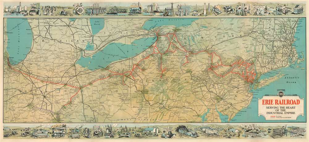
Erie Railroad Serving the Heart of the Industrial Empire.
1930 (dated) 18.5 x 40.5 in (46.99 x 102.87 cm) 1 : 1413280
1930 (dated) 18.5 x 40.5 in (46.99 x 102.87 cm) 1 : 1413280
Description
This is a highly graphic 1930 Whitney-Graham railroad map of the northeastern United States issued to promote industrial development along the Erie Railroad.
A Closer Look
Coverage extends from Chicago to Cape Cod and from Portland, Maine, and Lake Ontario to Cincinnati, Ohio, and Washington D.C. Red lines trace the routes of the Erie Railroad from Jersey City to Chicago. Purple lines mark the few tracks where the Erie Railroad has Trackage Rights but does not own the rails. Numerous other railroads are illustrated throughout, including the Pennsylvania Railroad, the New York Central and Saint Louis, the Pere Marquette Railway, and the Reading. A series of pictorial vignettes along the top and bottom highlight American manufacturing, agriculture, ranching, and shipping.Industry Along the Erie Railroad
This map is a promotional piece intended to court industrial development along the main Erie Railroad Trunk Line. Large farms, factories, warehouses, and shipping depots could apply to have connecting lines constructed right to their doors. Such connections were highly profitable for major railroads, as they forced all traffic onto owned or affiliate lines.The Erie Railroad
The Erie Railroad was founded in 1832 as the 'New York and Erie Rail Road'. The original plan for the railroad was to connect Jersey City, New Jersey, with Lake Erie. IN 1895, following several bankruptcies, acquisitions, and mergers, it was renamed the Erie Railroad. By this time, it had expanded as far as Chicago, with tributary lines servicing Cincinnati, Cleveland, and Buffalo. In 1960, it merged with 'Delaware, Lackawanna, and Western Railroad' to form the Erie Lackawanna Railroad. The Erie Lackawanna Railroad existed until 1976 when it was acquired by Conrail. Today, remnants of the Erie Railroad are parts of New Jersey Transit, but most of the surviving routes are operated by the Norfolk Southern Railway.Publication History and Census
This map was created by the Whitney-Graham Company and published in 1930 by the Erie Railroad. Three examples are cataloged in OCLC and are part of the institutional collection at the Indiana Historical Society, the University of Chicago, and Stanford University. An example is also part of the David Rumsey Map Collection.Cartographer
The Whitney-Graham Company (fl. c. 1926 - 1942) was a printing and publishing company based in Buffalo, New York active in the early- to mid-twentieth century. The company was headed by Merle B. Whitney and H.H. Graham, both of whom previously worked for Mathews-Northrup based in Washington, D.C. More by this mapmaker...
Condition
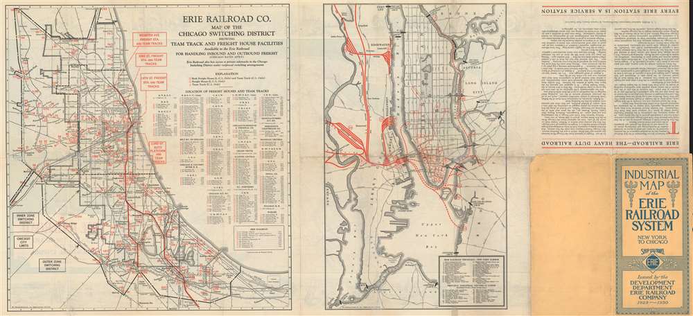
Good. Exhibits wear along original fold lines. Verso repairs to fold separations. Maps of Chicago and New York City on verso. Attached to original binder.
References
Rumsey 12329.002. OCLC 57126719.