This item below is out of stock, but another example (left) is available. To view the available item, click "Details."
Details
1935 Asahi Shimbun Japanese Map of Ethiopia, Abyssinia Crisis
$750.00
1935 Asahi Shimbun Japanese Map of Ethiopia
Ethiopia-asahishimbun-1935$375.00

Title
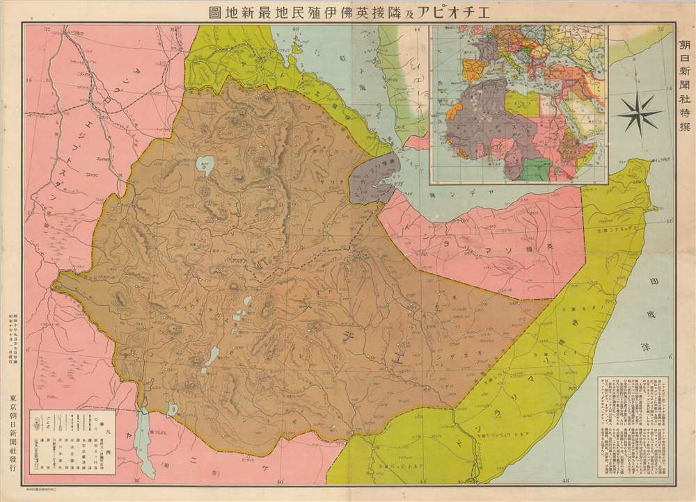
Latest Map of Ethiopia and neighboring British, French and Italian colonies. / エチオピア及隣接英佛伊殖民地最新地圖
1935 (dated) 15.25 x 21 in (38.735 x 53.34 cm) 1 : 4355500
1935 (dated) 15.25 x 21 in (38.735 x 53.34 cm) 1 : 4355500
Description
An intriguing September 1935 Japanese map of Ethiopia at the outbreak of the Second Italo-Ethiopian War (1835 - 1837). Illustrating a little-known episode in pre-WWII history wherein Japan was attempting to create an 'Alliance of Non-White Peoples.' The map covers all of modern-day Ethiopia, as well as parts of Eretria, Somalia, Djibouti, Sudan, and Kenya. An inset in the upper right situates Ethiopia in the context of North Africa, and a text block in the lower right descripts the people and geography.
Alliance of non-White Peoples
As Imperial Japan grew in power in the heady days before the full-scale outbreak of World War II, Imperial Japan began pushing for an alliance with Ethiopia, part of what was dubbed the 'Alliance of non-White Peoples'. While the alliance never formalized, it is easy to see why Japan and Ethiopia might find common ground. Both were ancient hereditary empires, never conquered or dependent upon another nation. Both considered themselves oppressed by foreign powers - Japan had deteriorating relations with England and the United States, and Ethiopia was constantly threatened by Italian colonial interests. As the Japanese defeated Russia in the Russo-Japanese War (1899 - 1905), Ethiopia was at this very moment actively fighting against a second Italian attempt at conquest in the Second Italo-Ethiopian War (1935 - 1837). Moreover, as doors in Europe and America closed to Japanese trade, Japan was eager for new economic outlets. It also posited a network of alliances that could, collectively, stand up to European bullying. Japanese offices toured Ethiopia and talks began, but ultimate, Ethiopia had enough internal problems that the alliance proved untenable.Publication History and Census
This map was printed on September 7, 1935 and released on October 1st. It was published as a special supplement to the Tokyo Asahi Shimbun (朝日新聞). Scarce. We are aware of no other examples.Cartographer
The Asahi Shimbun (朝日新聞; January 25, 1879 – Present), translated Morning Sun Newspaper, is one of Japan's oldest and most venerable daily newspapers. The Asahi Shimbun began publication in Osaka on January 25, 1879 as a small-print, four-page illustrated paper. The paper was founded by Kimura Noboru (company president), Murayama Ryōhei (owner), and Tsuda Tei (managing editor). In 1888 the newspaper expanded with a branch in Tokyo and began issuing the Tokyo Asahi Shimbun. The the Osaka and Tokyo papers formally merged under a single imprint in 1940. Almost from its inception the newspaper was known for its liberal views. The Asahi Shimbun continues to publish from Osaka today. More by this mapmaker...
Condition
Very good. Some wear on old fold lines. Light surface abrasion.