
This item below is out of stock, but another example (left) is available. To view the available item, click "Details."
Details
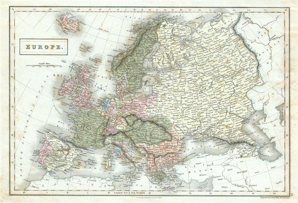
1844 Black Map of Europe
1844 (undated) $100.00
1851 Black Map of Europe
Europe-black-1851$50.00

Title
Europe.
1851 (undated) 11 x 16 in (27.94 x 40.64 cm)
1851 (undated) 11 x 16 in (27.94 x 40.64 cm)
Description
This is a fine example of Adam and Charles Black's 1851 map of europe. The map covers the continent in its entirety from the North Atlantic Ocean to the Caspian Sea and from the Arctic Sea to the Mediterranean Sea, including Iceland. It shows the Austrian empire at its height, the many states of the German Confederacy, and a pre-Garibaldi Italy split into numerous small duchies and states. It notes the legendary and semi-mythical whirlpool known as the Lofoten Maelstrom (Malstrom) in northwestern Norway. This map was created at a time in history that witnessed the unification of Italy and saw the British empire rise to its peak. It was also a time of decline for the Ottoman empire. Various towns, cities, rivers, mountains and several other topographical details are noted with relief shown by hachure. This map was engraved by Sidney Hall and issued as plate no. VI in the 1851 edition of Black's General Atlas of the World.
CartographerS
Charles and Adam Black (fl. 1807 - present) were map and book publishers based in Edinburgh. Charles and his uncle, Adam, both of Edinburgh, Scotland, founded their publishing firm in 1807. They published a series of maps and atlases throughout the 19th century. In addition to an array of atlases, the Black firm is known for their editions of the Encyclopedia Britannica (1817 - 1826) and the first publishing of Sir Walter Scott's novels in 1854. In 1889 the A. & C. Black publishing house moved to London where it remains in operation to this day. More by this mapmaker...
Sidney Hall (1788 - 1831) was an English engraver and map publisher active in London during the late 18th and early 19th centuries. His earliest imprints, dating to about 1814, suggest a partnership with Michael Thomson, another prominent English map engraver. Hall engraved for most of the prominent London map publishers of his day, including Aaron Arrowsmith, William Faden, William Harwood, and John Thomson, among others. Hall is credited as being one of the earliest adopters of steel plate engraving, a technique that allowed for finer detail and larger print runs due to the exceptional hardness of the medium. Upon his early death - he was only in his 40s - Hall's business was inherited by his wife, Selina Hall, who continued to publish under the imprint, "S. Hall", presumably for continuity. The business eventually passed to Sidney and Selina's nephew Edward Weller, who became extremely prominent in his own right. Learn More...
Source
Black, A. and C., General Atlas Of The World, (Edinburgh) 1851.
Condition
Very good. Minor overall toning. Blank on verso. Minor foxing.
References
Rumsey 2305.012 (1854 edition). Philips (atlases) 4334.