
This item below is out of stock, but another example (left) is available. To view the available item, click "Details."
Details
1939 Sears and Roebuck Map of the Predicted Theatre of World War II
1939 (dated) $175.00
1891 Rand McNally Map of Europe
Europe-randmcnally-1895$37.50

Title
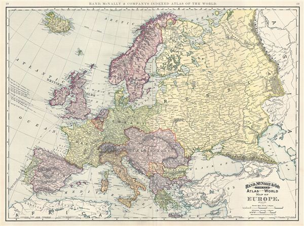
Map of Europe.
1891 (dated) 20 x 27 in (50.8 x 68.58 cm) 1 : 8900000
1891 (dated) 20 x 27 in (50.8 x 68.58 cm) 1 : 8900000
Description
This is a beautiful example of Rand McNally and Company's 1891 map of Europe. The map covers the continent in its entirety from the Atlantic to the Caspian Sea and from the Arctic Ocean to the Mediterranean Sea and includes Iceland. This map depicts a period following the unification of Italy and the rise of the British Empire to its apex of power and influence. It was also a time of decline for the Ottoman Empire. This map follows the period after the unification of Germany. Various submarine telegraph lines are noted. Color coded according to regions and territories, the map notes several towns, cities, rivers, railroads and various other topographical details with relief shown by hachure. This map was issued as plate nos. 18 and 19 in the 1895 issue of Rand McNally and Company's Indexed Atlas of the World - possibly the finest atlas Rand McNally ever issued.
Cartographer
Rand, McNally and Co. (fl. 1856 - present) is an American publisher of maps, atlases and globes. The company was founded in 1856 when William H. Rand, a native of Quincy, Massachusetts, opened a print shop in Chicago. Rand hired the recent Irish immigrant Andrew McNally to assist in the shop giving him a wage of 9 USD per week. The duo landed several important contracts, including the Tribune's (later renamed the Chicago Tribune) printing operation. In 1872, Rand McNally produced its first map, a railroad guide, using a new cost effective printing technique known as wax process engraving. As Chicago developed as a railway hub, the Rand firm, now incorporated as Rand McNally, began producing a wide array of railroad maps and guides. Over time, the firm expanded into atlases, globes, educational material, and general literature. By embracing the wax engraving process, Rand McNally was able to dominate the map and atlas market, pushing more traditional American lithographic publishers like Colton, Johnson, and Mitchell out of business. Eventually Rand McNally opened an annex office in New York City headed by Caleb S. Hammond, whose name is today synonymous with maps and atlases, and who later started his own map company, C. S. Hammond & Co. Both firms remain in business. More by this mapmaker...
Source
Rand McNally & Co., Foreign Countries. Rand, McNally & Co's Indexed Atlas of the World (Complete in Two Volumes)…, (Chicago) 1895.
Condition
Very good. Minor wear along original centerfold. Text on verso.
References
Rumsey 3565.006 (1897 edition). Philip (atlases) 1026 (1898 edition).