This item has been sold, but you can get on the Waitlist to be notified if another example becomes available, or purchase a digital scan.
1830 Lapie Map of Europe under Charlemagne and Charles V
EuropeCharlemagne-lapie-1829$87.50

Title
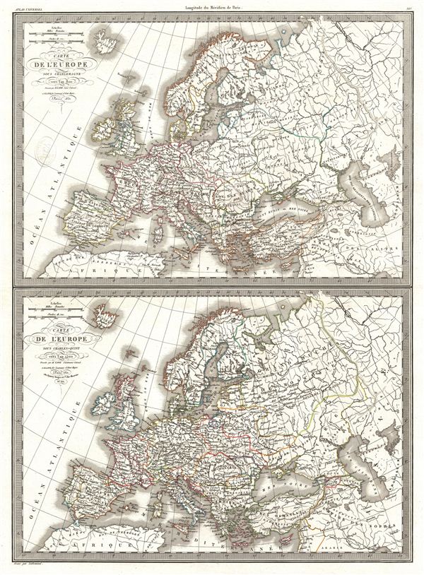
Carte de l'Europe sous Charlemagne vers l'an 800. Carte de l'Europe sous Charles-Quint vers l'an 1500.
1830 (dated) 22.5 x 16.5 in (57.15 x 41.91 cm)
1830 (dated) 22.5 x 16.5 in (57.15 x 41.91 cm)
Description
A fine first edition example of M. Lapie's map contrasting europe under Charlemagne in 800 versus europe under Charles V in 1500. The map is divided into two parts, with the upper showing europe under Charlemagne in 800 AD and the lower half detailing europe under Charles V in 1500 AD. After ruling and reforming France in 768, Charlemagne conquered Italy and, in 800, was crowned Holy Roman emperor. For the next 14 years until his death, Charlemagne's empire united much of Western and Central europe for the first time since the Romans, and the ‘Carolingian Renaissance' witnessed a Catholic themed revival of art, religion, and culture, encouraging the formation of a common european identity. Like Charlemagne, Charles V started off a mere king, in his case of Spain, and went on to rule the largest realm in europe since Charlemagne. Like Charlemagne, Charles V attacked Rome and, again like Charlemagne, was crowned Holy Roman emperor for his efforts. (Note: though a demonstrably winning strategy, Geographicus does not condone this tactic today). Charles V also oversaw vast colonial holdings in the New World and Asia, which probably helped fund his Inquisitors and the battle against Martin Luther's Protestant Reformation.
This map would make a fine companion map to Lapie's other historical maps of europe from the same atlas. engraved by Armand Joseph Lallemand as plate no. 18 in the first edition of M. Lapie's important Atlas Universel. This map, like all maps from the Atlas Universel features an embossed stamp from the Lapie firm.
This map would make a fine companion map to Lapie's other historical maps of europe from the same atlas. engraved by Armand Joseph Lallemand as plate no. 18 in the first edition of M. Lapie's important Atlas Universel. This map, like all maps from the Atlas Universel features an embossed stamp from the Lapie firm.
CartographerS
Pierre M. Lapie (fl. 1779 - 1850) and his son Alexandre Emile Lapie (fl. 1809 - 1850) were French cartographers and engravers active in the early part of the 19th century. The Lapies were commissioned officers in the French army holding the ranks of Colonel and Capitan, respectively. Alexander enjoyed the title of "First Geographer to the King", and this title appears on several of his atlases. Both father and son were exceptional engravers and fastidious cartographers. Working separately and jointly they published four important atlases, an 1811 Atlas of the French Empire (Alexander), the 1812 Atlas Classique et Universel (Pierre), the Atlas Universel de Geographie Ancienne et Modern (joint issue), and the 1848 Atlas Militaire (Alexander). They also issued many smaller maps and independent issues. All of these are products of exceptional beauty and detail. Despite producing many beautiful maps and atlases, the work of the Lapie family remains largely underappreciated by most modern collectors and map historians. The later 19th century cartographer A. H. Dufour claimed to be a student of Lapie, though it is unclear if he was referring to the father or the son. The work of the Lapie firm, with its precise engraving and informational density, strongly influenced the mid-19th century German commercial map publishers whose maps would eventually dominate the continental market. More by this mapmaker...
Armand Joseph Lallemand (c. 1810 - 1871) was an engraver and map publisher based in Paris during the mid-19th century. Most of Lallemand's work focused on landscapes and building vies, though he did take part in a few cartographic ventures, including the production of an atlas with Alexandre Emile Lapie and several tourist pocket maps of Paris. Learn More...
Source
Lapie, M., Atlas Universel de Geographie. Ancienne et Moderne, precede d'un Abrege de Geographic Physique et Historique…, 1829. (Rumsey identifies this as the first edition of Lapie's Atlas Universel. In all known examples, the title page is dated 1829 while the maps are dated variously to 1833 - suggesting that the first issue of this atlas was 1833, not 1829.)
Condition
Very good. Original platemark visible. Blank on verso. Original centerfold.
References
Rumsey 2174.018. Phillips (Atlases) 754, 765.