This item has been sold, but you can get on the Waitlist to be notified if another example becomes available, or purchase a digital scan.
1854 Mitchell Map of Europe
EuropeLatest-mitchell-1854$100.00

Title
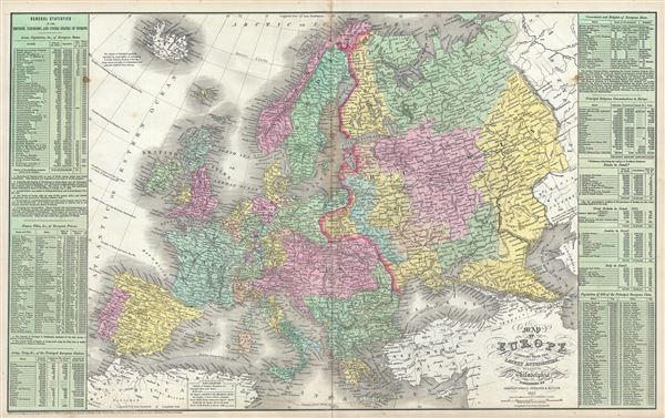
Map of Europe Compiled from the Latest Authorities.
1854 (dated) 16 x 27 in (40.64 x 68.58 cm) 1 : 10400000
1854 (dated) 16 x 27 in (40.64 x 68.58 cm) 1 : 10400000
Description
This is a scarce Thomas Cowperthwait and S. A. Mitchell's 1854 map of Europe. It covers the entirety of the continent, including Iceland and parts of Turkey, from the Arctic Ocean to the Mediterranean Sea and from the Atlantic Ocean eastward as far as the Caspian Sea. The whole is engraved and colored in Mitchell's distinctive style with green border work and vivid pastels. Political and topographical features are noted and color coded with elevation rendered by hachure. The left and right sides of the map proper features tables of general statistics.
Mitchell reveals the Austrian empire at its height, the many states of the German Confederacy, and a pre-Garibaldi Italy split into numerous small Duchies and states. This map was created during an exciting historical period that witnessed the unification of Italy and saw the British Empire rise to its peak.
This map was prepared by S. A. Mitchell for publication by the Philadelphia firm of Thomas Cowperthwait and Co. in the 1854 edition of Mitchell's New General Atlas. Dated and copyrighted, 'Entered according to act of Congress in the year 1854 by Thomas Cowperthwait and Co. in the Clerk's office of the Eastern District of Pennsylvania.'
Cartographer
Samuel Augustus Mitchell (March 20, 1792 - December 20, 1868) began his map publishing career in the early 1830s. Mitchell was born in Bristol, Connecticut. He relocated to Philadelphia in 1821. Having worked as a school teacher and a geographical writer, Mitchell was frustrated with the low quality and inaccuracy of school texts of the period. His first maps were an attempt to rectify this problem. In the next 20 years Mitchell would become the most prominent American map publisher of the mid-19th century. Mitchell worked with prominent engravers J. H. Young, H. S. Tanner, and H. N. Burroughs before attaining the full copyright on his maps in 1847. In 1849 Mitchell either partnered with or sold his plates to Thomas, Cowperthwait and Company who continued to publish the Mitchell's Universal Atlas. By about 1856 most of the Mitchell plates and copyrights were acquired by Charles Desilver who continued to publish the maps, many with modified borders and color schemes, until Mitchell's son, Samuel Augustus Mitchell Junior, entered the picture. In 1859, S.A. Mitchell Jr. purchased most of the plates back from Desilver and introduced his own floral motif border. From 1860 on, he published his own editions of the New General Atlas. The younger Mitchell became as prominent as his father, publishing maps and atlases until 1887, when most of the copyrights were again sold and the Mitchell firm closed its doors for the final time. More by this mapmaker...
Source
Mitchell, S. A., A New Universal Atlas Containing Maps of the various Empires, Kingdoms, States and Republics Of The World, (Thomas Cowperthwait & Co., Philadelphia) 1854.
Condition
Very good. Minor wear and toning along original centerfold. Some foxing at places. Verso repair along rips near centerfold and margins.
References
Rumsey 2514.049 (1857 edition).