This item has been sold, but you can get on the Waitlist to be notified if another example becomes available, or purchase a digital scan.
1872 Yves and Barret Pictorial Map of Europe after the Franco-Prussian War
EuropePolitico-yvesbarret-1872$475.00

Title
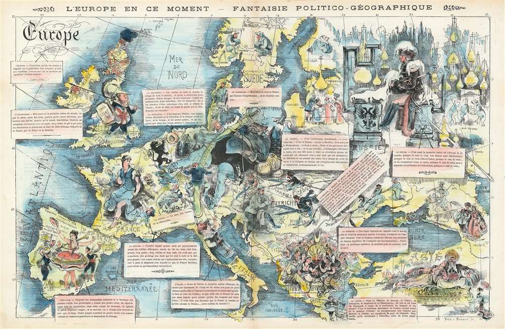
L'Europe en Ce Moment - Fantaise Politico-Géographique.
1872 (dated) 13 x 20.5 in (33.02 x 52.07 cm)
1872 (dated) 13 x 20.5 in (33.02 x 52.07 cm)
Description
This is an 1872 Yves and Barret caricature map of Europe after the Franco-Prussian War. Coverage embraces all of Europe, from the Atlantic Ocean to the Caspian Sea and from Scandinavia and the Shetland Islands to the Mediterranean Sea. Illustrated personifications of each nation define the author's political viewpoints. Newly united Germany dominates central Europe in the form of the Kaiser, who is sprawled across what the French must have considered to be an ominously large territory. He reclines against a cannon and artillery shells, accompanied by a gigantic sword and an empty beer stein - suggesting at once military power, belligerence, and instability. A much smaller German soldier is illustrated holding the puppet strings of several other European countries, including Italy, Spain, and Austria. France, which had just lost the Franco-Prussian War, is represented as Marianne, the French national symbol, being tended by smaller officials and military men. The men are trying to get her to hold back her anger at having German guns pointed at her from Strasbourg (Alsace and Lorraine were annexed by Germany after the Franco-Prussian War) and to form a new government following the defeat, as well as the chaos of the Paris Commune. England is illustrated as a man in armor decorated with the Union Jack holding a book for a shield. He is surrounded by the Bible and bales of cotton. Spain, Italy, and Austria are depicted as contentedly going about their business, per the German soldier's wishes, but the Austrians are illustrated holding scissors, possibly to try to cut ties with the now overly powerful Germany. Russia is a frozen wasteland with their onion-domed churches and a land where everything happens 'because the czar wants it to be'. The Turks represented as a caricature of eastern decadence: a single man surrounded by elegantly dressed women attending to his every whim.
Publication History and Census
This map was engraved by Yves and Barret and published in the July 6, 1872 La Vie Parisienne. We are aware of two examples in institutional collections, the David Rumsey Map Collection at Stanford University and Persuasive Maps: the PJ Mode Collection at Cornell University. This map is incredibly rare on the private market.Cartographer
Yves et Barret (fl. c. 1870 - 1890) were French engravers active in the late 19th century. They engraved political cartoons and other images for French periodicals, including La Vie Parisienne. This partnership was known for creating works using gillotage, a now obsolete lithographic process wherein a drawing was made on or transferred to zinc and then dusted with resin, which adhered to the drawing. The resin then acted as an acid-resist when the entire plate was immersed in acid, creating a relief block that could then be inked and printed from. This printing technique was popular with newspapers, as it was completely compatible with blocks of type. More by this mapmaker...
Source
Yves et Barret, 'L'Europe en Ce Moment - Fantaise Politico-Géographique.' La Vie parisienne, July 6, 1872.
Condition
Very good. Even overall toning. Light wear along original centerfold. Text on verso.
References
Cornell University, Persuasive Maps: PJ Mode Collection, 2082.01. Rumsey 8073.000. OCLC 953572701.