1977 Mandala Trekking Map of Mount Everest and Vicinity
Everest-mandala-1977$500.00


Title
Latest Trekking Map Lamosangu to Mt Everest Showing whole of the Kumbu Himal, Rolwaling Himal, Namche Bazar to Everest Base Camp, Kokyo Course and Namche Bazar.
1977 (undated) 37.75 x 28 in (95.885 x 71.12 cm) 1 : 101376
1977 (undated) 37.75 x 28 in (95.885 x 71.12 cm) 1 : 101376
Description
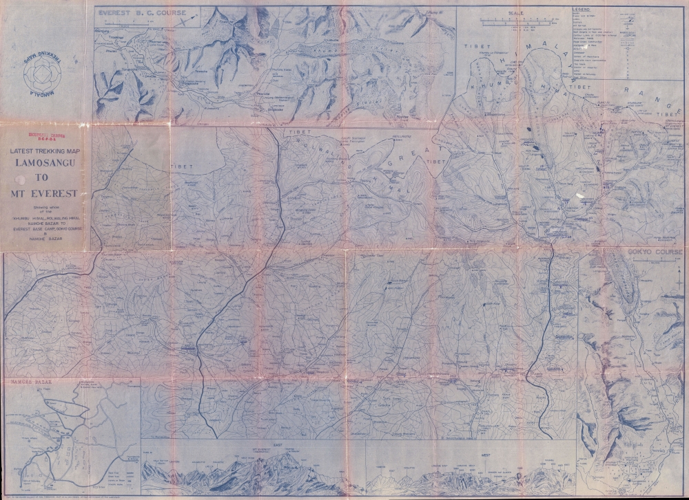
This is a one-of-a-kind c. 1977 Mandala Trekking Maps mimeographed map of the Khumbu, or Everest, region of Nepal.
A Closer Look
The map depicts the region from the Sun Kosi River to Mt. Everest, Lhotse, and Lhotse Shar and from Tibet to Phaplu. As topography is incredibly important in this part of the world, topographic lines cover the map, with labeled peaks and elevations populating every corner of the map. Three inset maps are included around the central map. One of these, along the top border, illustrates the route to Everest Base Camp and labels the villages along the way. Khumbu Glacier and the legendary Ice Fall are both labeled as well. The inset map detailing the 'Gokyo Course' is situated in the lower right corner. The Gokyo trek is one of the most popular in the region and allows for spectacular views of Everest. The third inset map is a city map of Namche Bazaar, which is the main trading center of the region and a popular stop for trekkers for altitude acclimatization. A profile view of the Himalayas is situated along the bottom border and labels over a dozen peaks with numerous other elevations labeled as well.Follow a Trek Through the Himalayas
It appears this map was used for a trek, although it is unclear exactly when the expedition took place. It began in Kirantichap and lasted twenty-five days and the villages where the hikers spent the night are underlined and numbered. Villages throughout the region are labeled, with elevations given for most of them. The famous Everest regions acclimatization stops were waypoints on this trip, including Lukla, Namche Bazaar, Gorak Shep, and Gokyo. Although the members of this expedition did not reach Everest Base Camp, they ascended Kala Patthar which offers even better views of Everest than those offered by Everest Base Camp.Publication History
This map was produced by Mandala Trekking Maps c. 1977.Condition
Very good. Wear along original fold lines. Verso repairs of fold separations.