This item has been sold, but you can get on the Waitlist to be notified if another example becomes available, or purchase a digital scan.
1904 Service Géographique de l'Armée Map of Korea and Northeastern China
ExtremoOriente-armee-1904$750.00


Title
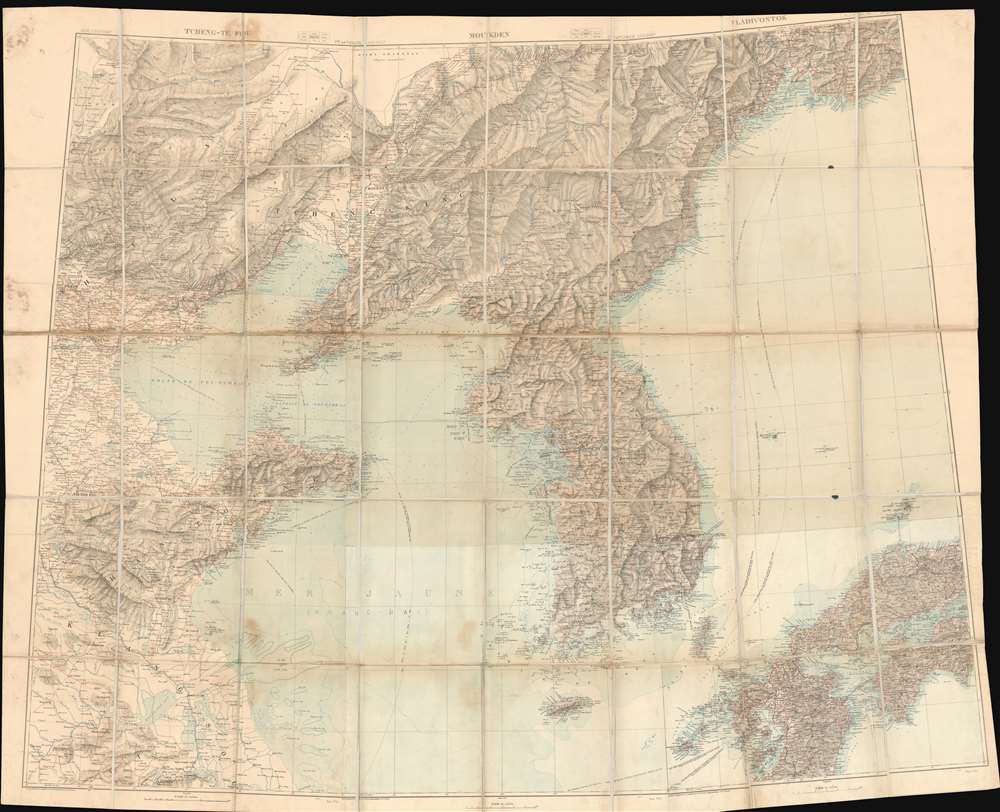
Tcheng-Te Fou. Moukden. Vladivostok.
1904 (undated) 57 x 71.25 in (144.78 x 180.975 cm) 1 : 1000000
1904 (undated) 57 x 71.25 in (144.78 x 180.975 cm) 1 : 1000000
Description
This is a gigantic c. 1904 wall map of Korea and northeastern China during the era of the Russo-Japanese War. Compiled from nine Service Géographique de l'Armée maps, this unique piece likely helped French military officials visualize the fighting in the region during the war. Incredibly detailed, myriad cities and towns are labeled throughout. Particular focus is paid to the Liaodang Peninsula and the spur rail line constructed by the Russians connecting Mukden and Port Arthur, where every stop is identified. Other rail lines around the region are illustrated as well, along with roads, rivers, and mountain ranges. Beijing (Pekin), Nanjing (Nankin), Seoul, and Vladivostok are all appear.
There was initially some attempt at negotiation between the imperialist powers, but Tsar Nicholas II arrogantly believed it impossible that Japan could challenge a major European power. Japan proved him wrong, launching a surprise attack on the Russian Eastern Fleet stationed at Port Arthur. Throughout the course of the war, the Russians were defeated again and again, humiliating the Tsar and forcing U.S. President Theodore Roosevelt to arbitrate a peace, confirmed by the Treaty of Portsmouth. The treaty recognized Japan's claims on Korea and called for the evacuation of Russian forces from Manchuria, including from Port Arthur.
The overwhelming victory of Imperial Japan came as a surprise to international observers, being the first major military victory in the modern era of an Asian over European power. The consequences transformed the balance of power, confirmed Japan as the pre-eminent power in East Asia.
Russo-Japanese War
The Russo-Japanese War, fought from February 8, 1904 - September 5, 1905, pitted Imperial Japan against Tsarist Russia over rival imperial ambitions in Manchuria and Korea. Both Russia and Japan had grand visions for the region. Russia traditionally had only one Pacific port, Vladivostok, which was operational only during the warm summer months. In 1898, Russia coerced China, then weakened after the First Sino-Japanese War (1894 - 1895), to lease Port Arthur, a warm water port on the Liaodang Peninsula. They also negotiated a right-of-way to connect Port Arthur to the China Eastern Railway, which ran from nearby Dalian (Dalny) to Harbin, a stop on the Siberian Railway. Russia, eager to expand southwards from Siberia, considered Port Arthur the cornerstone of a sphere of influence covering China, Manchuria, and Korea. Japan had its own Imperial ambitions and saw itself as the natural overlord in East Asia. Korea and Manchuria in particular were important as steppingstones into China, with its seemly unlimited resources.There was initially some attempt at negotiation between the imperialist powers, but Tsar Nicholas II arrogantly believed it impossible that Japan could challenge a major European power. Japan proved him wrong, launching a surprise attack on the Russian Eastern Fleet stationed at Port Arthur. Throughout the course of the war, the Russians were defeated again and again, humiliating the Tsar and forcing U.S. President Theodore Roosevelt to arbitrate a peace, confirmed by the Treaty of Portsmouth. The treaty recognized Japan's claims on Korea and called for the evacuation of Russian forces from Manchuria, including from Port Arthur.
The overwhelming victory of Imperial Japan came as a surprise to international observers, being the first major military victory in the modern era of an Asian over European power. The consequences transformed the balance of power, confirmed Japan as the pre-eminent power in East Asia.
Publication History and Census
The maps used to compile this incredible piece were created and published by the Service Géographique de l'Armée c. 1904. The individual sheets that create this map are incredibly rare and scarcely appear on the private market. Taken as a whole, this piece likely represents a one-of-a-kind find that would make an incredible addition to any collection focused on the Far East or for anyone with particular interest in military cartography.Cartographer
Service Geographique de L'Armee (fl. 1887 - 1940) was a French military mapping service. They published from 14c. Rue de Grenelle, Paris, France. More by this mapmaker...
Condition
Good. Dissected and mounted on original linen in thirty (30) panels. Exhibits some wear and soiling.