1915 F. L. Anders City Plan or Map of Fargo, North Dakota
Fargo-anders-1915$2,400.00


Title
F. L. Anders' Map of the City of Fargo Cass County North Dakota.
1915 (dated) 27 x 44 in (68.58 x 111.76 cm) 1 : 3600
1915 (dated) 27 x 44 in (68.58 x 111.76 cm) 1 : 3600
Description
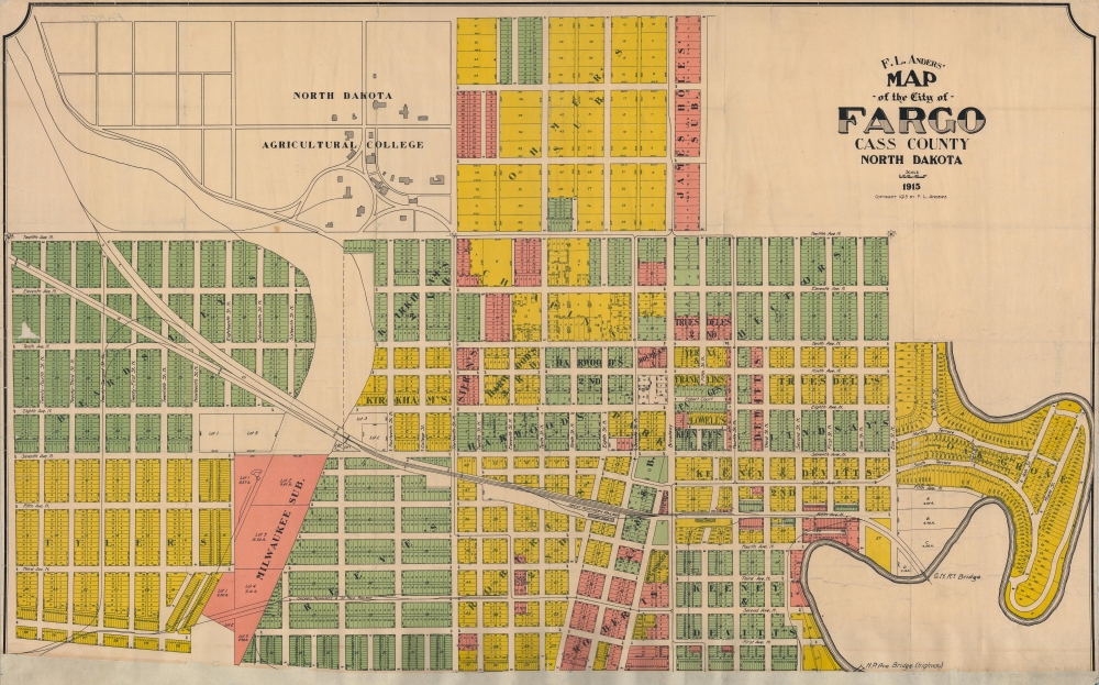
This is a 1915 Frank L. Anders city planning map of Fargo, North Dakota. This was the official city planning map of Fargo during its early 20th century boom as a grain and railroad town.
A Closer Look
The map depicts Fargo from 15th Avenue North to 1st Avenue North and from 24th Street North to the Red River. Colors shade private estates, developments, and land holdings, each labeled with the name of its owner, except for Oak Grove. Streets and avenues are labeled with street width is provided. The entirety of Fargo has been divided into lots, with the dimensions of each lot provided. The Great Northern Railway runs through town and both Passenger and Freight Depots are identified. The North Dakota Agricultural College's campus, today known as North Dakota State University, occupies the upper left.A Home to Immigrants
In the early 20th century, Fargo, North Dakota, underwent significant urban development, marking its transition from a railway frontier town to a burgeoning regional center. Its strategic position along the Northern Pacific Railway spurred growth, attracting businesses and settlers - most immigrants of German or Scandinavian descent. The devastating fire of 1893, which consumed much of the original wooden downtown, paved the way for a city rebuilt with brick and stone, showcasing modern amenities. As the agricultural sector flourished, thanks to the fertile Red River Valley, Fargo became a hub for grain processing. Educational and cultural institutions, such as the North Dakota Agricultural College (now North Dakota State University), established during this era, further enhanced the city's stature, making it not just an economic but also a cultural epicenter.The Fargo and Moorhead Street Railway
Although unlabeled, the lines of the Fargo and Moorhead Street Railway are illustrated throughout this map. The Fargo and Moorhead Street Railway began operations on November 24, 1904, Thanksgiving Day, after 2.5 years of planning and construction. At that time fares were 5 cents and the system consisted of three lines: the north side loop, the south side loop, and the Oak Grove line. Streetcars operated from 6 a.m. to midnight, except on Sundays. Service operated in Fargo until 1937.Publication History and Census
This map was created and published by Frank L. Anders in 1915 when he was Fargo's city engineer. It is the northern section of what appears to have been a two-sheet map, although the southern sheet may never have been made and, this being the only known example, is otherwise unknown.Cartographer
Frank Lafayette Anders (November 10, 1875 - January 20, 1966) was an American Army veteran, Medal of Honor recipient, and civil engineer. Born at Fort Abraham Lincoln in the Dakota Territory, Anders' father was a member of Company G, 17th U.S. Infantry, and served under Colonel George Armstrong Custer. As an infant, Anders witnessed Custer lead the 7th Cavalry out of Fort Lincoln to the Battle of Little Bighorn. At some point in 1876 or 1877 the Anders family moved to Fargo after his father was discharged from the Army. His father died when he was 15 from wounds suffered during the American Civil War. At that point Anders left school (with a 7th grade education) and found a job working for the Northern Pacific Railway as a call boy. He enlisted in Company B of the 1st Regiment of the North Dakota National Guard in December 1894 and was in his second enlistment when his unit was sent to the Philippines during the Spanish-American War. Once in the Philippines he was assigned to Young's Scouts, a hand picked unit of soldiers known for their marksmanship. He was awarded the Medal of Honor for actions on May 13, 1899, during the Philippine American War, at a bridge near San Miguel. He and ten of his fellow scouts attacked a fortified trench manned by at least 300 enemy combatants and routed them. In September 1899 Anders returned to the U.S. and was discharged from the Army. After two years working for mining companies around Salt Lake City, Utah, Anders realized that he needed a college education to progress in his chosen profession. In 1902 he enrolled in Ripon College in Ripon, Wisconsin, and graduated head of his class in 1906. Then he attended the University of Wisconsin for a year in its civil engineering program before finding a job with a copper company in Utah. In 1909 he returned to Fargo where he worked as a civil engineer and soon became City Engineer, a position he held until 1919. He was commissioned a captain in the Engineering Corps in 1918 and served at Camp Dodge (where he wrote the history of the camp) and Camp Funston, where he also conducted historical work and oversaw the hospital facilities, then the largest in the United States. He was discharged in 1919 and returned to Fargo, where he spent most of the rest of his life. Anders' son, Lieutenant Colonel Franklin O. Anders, also served in the U.S. Army. He fought in the Philippines during World War II and was a survivor of the Bataan Death March. Both Anders returned to the Philippines in 1961 and spent three months there. More by this mapmaker...
Condition
Good. Mounted on old linen. Some wear and crackling. Appears to be the northern sheet of a 2-sheet map, but the southern half is unknown and may never have been made.