
1950 Gulf Oil Company Fishing Map of Corpus Christi, Texas, and Environs

This item has been sold.
Gulf Oil Corp. Fishgide Corpus Christi.
Fishing in Corpus Christi Bay.
Choose a Collection:
- Digital Map Information
- Suitable for large format printing
- Full resolution TIFF file
- ICC color profile embedded
- Delivered instantly via download link
This Item
Enquire
Fishing in Corpus Christi Bay.
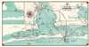
This is a c. 1950 Gulf Oil Company fishing map of Corpus Christi, Texas, and its vicinity. Corpus Christi Bay dominates the center with areas for trout, redfish, and flounder highlighted. Depth soundings ('at mean low water') in the Corpus Christi and Enginal Channel, are marked, although text along the bottom states the map is not to be used for navigation. Laguna Madre and the Gulf of Mexico (separated by Mustang Island, St. Joseph Island, and Padre Island) occupy the bottom portion of the map. More areas known for fishing are highlighted and causeways connecting Mustang Island and Padre Island with the mainland are illustrated. Since this is a fishing map, very little inland detail is included. Major roads are emphasized by bold black lines, and Corpus Christi, Aransas Pass, Port Aransas, and Rockport are illustrated by street grids. An inset in the upper left focuses on the mouth of Baffin Bay and part of Laguna Madre.Publication History and Census
This map was published by the Gulf Oil Company's 'Gulf Fishgide Bureau' c. 1950. This is the only known cataloged example of the present edition. Gulf Oil began publishing a set of seven maps known as 'fishgides' in 1939. We know the set was updated in 1950 and 1958 because of newspaper articles. We dated the present edition by the presence of the Padre Island causeway, which opened as a toll road in 1950.Condition
Very good. Light wear along original fold lines. Text on verso.