1956 Robertson Cyanotype Map of Oregon Placer Gold Deposits
GoldPlacerOregon-robertson-1956$250.00

Title
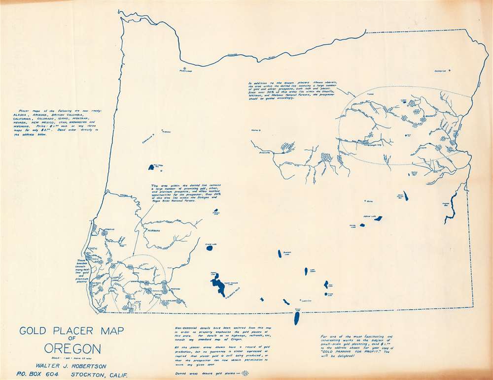
Gold Placer Map of Oregon.
1956 (undated) 16.5 x 21 in (41.91 x 53.34 cm) 1 : 145728
1956 (undated) 16.5 x 21 in (41.91 x 53.34 cm) 1 : 145728
Description
This is a c. 1956 Walter J. Robertson map of Oregon illustrating placer gold deposits. Dashed lines encircle the two principal gold districts: one in eastern Oregon and one in southwestern Oregon near the California border. Deposits are marked by clusters of blue dots. Rivers, creeks, and major cities and towns near these deposits are illustrated and labeled. Apart from these two regions, very little detail appears. Major lakes are depicted, including Crater Lake and Upper Klamath Lake. A few cities outside the gold-producing regions are noted, such as Portland, Albany, and Corvallis.
Gold Mining in Oregon
Gold was first discovered in Oregon in 1850. Fortune seekers rushed into Oregon, staking claims along the Rogue, Applegate, and Illinois Rivers. In 1861, gold was discovered in Baker County in eastern Oregon, sparking another rush. It took ten years for the placer gold deposits to be exhausted, which led to the implementation of lode mining. Gold mining in Oregon lasted through the mid-20th century but returns consistently diminished.Diazo Print or Whiteprint
The diazo print (whiteprint or diazo for short) is a photo reproductive technique best understood as a reverse cyanotype or blueprint. The process yields distinctive blue lines on white paper. Like cyanotypes, the diazo process gained popularity in architecture circles, where it was a simple and effective way to duplicate documents in the field. The earliest diazotypes appeared around 1880 and were adopted for military and field cartographic use from about 1895. The diazo process was commercialized in 1923, when the German firm, Kalle and Company, developed Ozalid, a patented diazo paper that made diazotyping even easier. By the 1950s, it supplemented cyanotypes as the reprographic technique of choice for technical drawings.Publication History and Census
This map was created and published by Walter J. Robertson c. 1956. This is the only known cataloged example.Cartographer
Walter James Robertson (October 2, 1910 - May 9, 1978) was an American publisher and cartographer. Born in Colorado, Robertson lived most of this life in Stockton, California. Beginning in the 1950s (or possibly earlier), Robertson began publishing materials dealing with mining, including a pamphlet titled 'Gold Panning for Profit'. He also published a series of placer mining maps of several western states, including Oregon, Arizona, and Northern and Southern California. More by this mapmaker...
Condition
Very good. Light wear along original fold lines. Light creasing.