
This item below is out of stock, but another example (left) is available. To view the available item, click "Details."
Details
1914 Brown Vexillology or Flag Chart of 'All Nations'
1914 (undated) $950.00
1934 Brown Chart of the World's Flags
FlagChart-brown-1934-2$475.00

Title
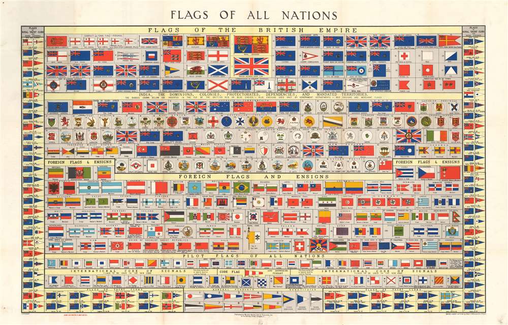
Flags of All Nations.
1934 (undated) 21.5 x 32.25 in (54.61 x 81.915 cm)
1934 (undated) 21.5 x 32.25 in (54.61 x 81.915 cm)
Description
This is Brown, Son and Ferguson's c. 1934 chart of the flags of all nations. A dramatic large format chart illustrating the flags of the world's maritime nations with a focus on the British Empire and its various extensions. The chart is divided into four primary sections. The upper section focuses on the British Empire, featuring flags from England, Scotland, Ireland, and various British military, commercial, government and postal carriers. Below this there are a series of flags and badges associated with colonies, dominions, protectorates, dependencies, and mandated states. These include India, Hong Kong, Gibraltar, the Falklands, the Unfederated Malay States, New Zealand, Canada, and more. In addition to proper flags, there are also a series of badges medallions that were added to the Union Jack to identify client states. Foreign flags and ensigns appear below. Among these are the flags of the United States, 'Koweit', Korea, Japan, Colombia, the Papal States, the Soviet Union, and more. Germany has four flags, all bearing the swastika, firmly dating this chart to the pre-war period of the German Third Reich, roughly 1933 to 1939.
Publication History and Census
This chart was published by Brown, Son, and Ferguson of Darnley Street Glasgow, Scotland. It was compiled and drawn by Ernest A. Manchester, a Fellow of the Royal Scottish Geographical Society. The map is undated, but variants of this chart exist from about 1910 to the 1950s. We are able to narrow the dating on this chart somewhat by the presence of the flag of the German Third Reich. The OCLC catalogs seven examples of this chart as part of the institutional collections at Brown University, the United States Naval Academy, the Peabody Essex Museum, the Columbia River Maritime Museum, the San Francisco Maritime National Historical Park, the National Art Library at the Victoria and Albert Museum, and the National Library of Sweden.Cartographer
Brown Son and Ferguson (1850 - present) are nautical publishers based in Glasgow, Scotland. The firm was founded around 1850 as a stationer servicing the nautical trade. Their location, near the docks, caused them to focus on nautical matters, printing navigation manuals, nautical charts, logbooks, and more. Founded in 1850 by James Brown, who was soon accompanied by his son Robert Brown, the firm began as a retail stationery business. In 1876, the firm published the first issue of Brown's Nautical Almanac, which was one of its first publications. Commonly known as 'The Sailor's Bible', Brown's Nautical Almanac is published annually and is still published to this day. The only exception was the September 1960 issue, when a fire ravaged the company's offices, including that month's issue of the Almanac. Brown, Son, and Ferguson published the Almanac monthly until December 2011, when Seabreezes Publications on the Isle of Man bought the magazine A history of the firm written by the current management suggest that Ferguson joined firm around 1939, but we have found the 'Brown Son and Ferguson' imprint on charts and other publications that can date no later than 1933. The firm registered as a Limited company in 1921. Decedents of the original founders still run the business from offices in Glasgow. More by this mapmaker...
Condition
Very good. Exhibits pinholing at corners in margins. Index printed on verso.
References
OCLC 1008491723.