This item has been sold, but you can get on the Waitlist to be notified if another example becomes available, or purchase a digital scan.
1872 Asher and Adams Map of Florida
Florida-asheradams-1872$87.50

Title
Asher and Adams' Florida.
1872 (dated) 16.75 x 24 in (42.545 x 60.96 cm) 1 : 1267200
1872 (dated) 16.75 x 24 in (42.545 x 60.96 cm) 1 : 1267200
Description
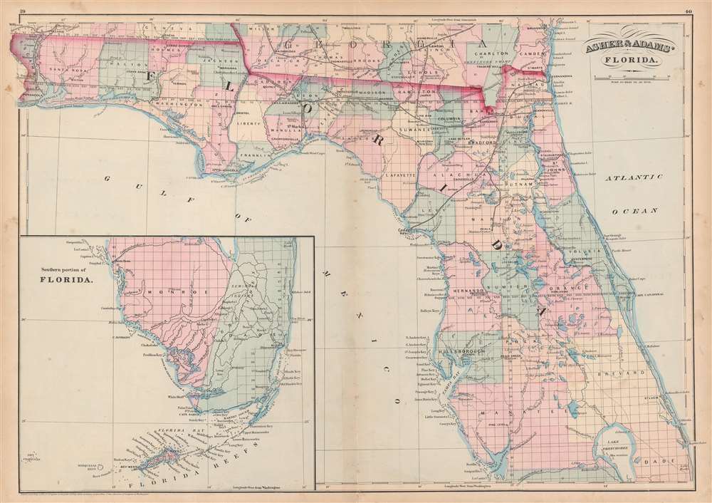
This is an 1872 Asher and Adams map of Florida. The map depicts the state from the Perdido River to the Atlantic Ocean and from Georgia and Alabama to Lake Okeechobee and Charlotte Harbor. An inset map situated in the Gulf of Mexico illustrates southern Florida from the Caloosahatchee River to the Florida Keys and Key West. Highly detailed, cities and towns throughout the state are labeled, including Tallahassee, Apalachicola, Pensacola, Jacksonville, St. Augustine, Tampa, and Miami. Rivers and lakes are also identified, as are several railroads, such as the Jacksonville, Pensacola, and Mobile Railroad, the Florida Central Railroad, and the Atlantic, Gulf, and West India Transit Company. The relatively short St. John's Railroad, which links St. Augustine to St. Augustine Inlet, is included as well. The route for the proposed Gulf Coast and Florida Peninsula Canal runs from Apalachee Bay through the panhandle toward Sulphur Springs. The township grid is overlaid on the entire state, allowing anyone to know in exactly which township a certain municipality is located.
This map was created by Asher and Adams for publication in the 1872 edition of Asher and Adams' New Commercial, Topographical, and Statistical Atlas and Gazetteer of the United States.
This map was created by Asher and Adams for publication in the 1872 edition of Asher and Adams' New Commercial, Topographical, and Statistical Atlas and Gazetteer of the United States.
Cartographer
Asher and Adams (fl. c. 1860 - c. 1900) were New York based cartographers active in the latter part of the 19th century. Active in the 1860s and 70s, the New York firm of Asher & Adams produced some of the most detailed and colorful late 19th century American Atlases. Asher & Adams are known for their remarkable state and county atlases which are so detailed that they include individual family homes and names. The Asher & Adams firm followed the quality and style formats pioneered by the earlier Colton and Johnson firms - notable for their distinctive pastel color washes and impressive size. Their most important work is their 1874 Asher & Adams Commercial and Statistical Gazetteer of the United States which is one of the first 19th century atlases to remove topographical information to make room for detailed depictions of railroads. More by this mapmaker...
Source
Asher and Adams, Asher and Adams' New Commercial, Topographical, and Statistical Atlas and Gazetteer of the United States (New York: Asher and Adams) 1872.
Condition
Very good. Wear and toning along original centerfold. Light soiling. Old verso repairs on verso. Verso repair to centerfold separation. Blank on verso.
References
Touchton Map Library M955.