This item has been sold, but you can get on the Waitlist to be notified if another example becomes available, or purchase a digital scan.
1922 Clason Map of Florida Promoting Daytona Beach
Florida-clason-1922-2$62.50

Title
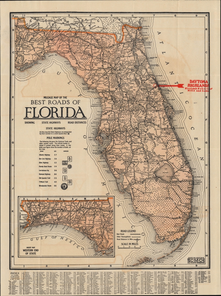
Milage Map of the Best Roads of Florida.
1922 (undated) 16 x 11.25 in (40.64 x 28.575 cm) 1 : 1520000
1922 (undated) 16 x 11.25 in (40.64 x 28.575 cm) 1 : 1520000
Description
This is the c. 1922 Clason folding road map of Florida. It corresponds with the Florida Land Boom of the 1920s and was issued to promote real estate development in the Daytona Highlands neighborhood of Daytona Beach.
Flagler and other boosters of the region successfully promoted it as a paradisical escape from the grimy cities and cold weather of New England and the Mid-Atlantic. Land prices shot up at an astronomical rate and developers carved entirely new cities out of wetlands in mere months. In addition to Flagler's railway, the arrival of the highway system and associated businesses (gas stations, motels, restaurants, etc.) in the 1920s made the region more easily accessible. But the speculation around land prices in Florida had reached irrational heights, and the damage caused by two hurricanes followed by the financial crash of 1929 led to a collapse in the real estate market, ruining many investors in the process.
A Closer Look
Coverage includes all of Florida, with the west Florida panhandle included via an inset. The map details major roadways throughout the state as well as roads under construction, such as the Tamiami Trail across the Everglades from Miami; these and other highways facilitated the tourist and real estate boom in Florida in the 1920s. Just to the north of the Tamiami Trail is the Seminole Indian Reservation known as 'Big Cypress'. The location of Daytona Highlands is prominently circled and labeled in red. A grid surrounds the map, with the coordinates and signage of national trails and other posted roads listed in a legend below the title. The coordinates and populations of larger towns and cities are provided in an index below the map.Daytona Highlands
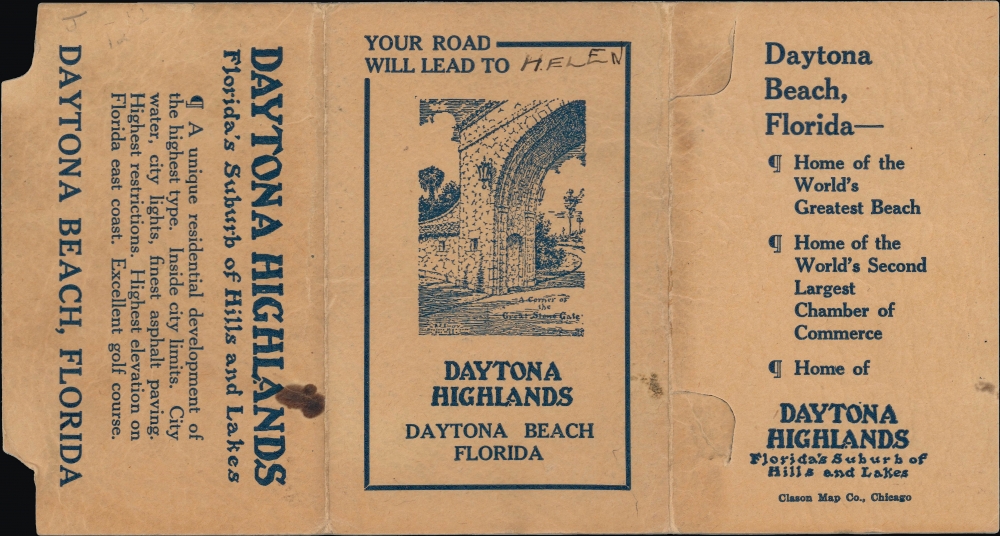
This map was issued in multiple editions, many with overprinting and verso printing to highlight various real estate developments and communities. The present example focuses on Daytona Highlands, a development and now neighborhood of Daytona Beach, northeast of Orlando. The cover lists the benefits and amenities of the community, including golf courses, beaches, the 'finest asphalt paving,' and the vague, disturbing promise of the 'highest restrictions.' A previous owner has added a pencil annotation so that the text above the cover illustration reads 'Your road will lead to Helen,' presumably their sweetheart. Today, Daytona Highlands is adjacent to the Daytona Beach International Airport as well as the city's greatest attraction, the Daytona International Speedway.Florida Land Boom
In the late 19th and early 20th century, Florida experienced a series of land booms and crashes; the most well-known of these occurred in the 1920s. The collapse of a previous land boom that established Florida as a center for the citrus industry in the 1880s - 1890s allowed for the easy acquisition of large tracts of land at cut-rate prices. Industrialist and founder of Standard Oil Henry Flagler (1830 - 1913) seized the opportunity to build his Florida East Coast Railway and extend it to the region that would develop into Miami and other communities on the state's southeastern coast.Flagler and other boosters of the region successfully promoted it as a paradisical escape from the grimy cities and cold weather of New England and the Mid-Atlantic. Land prices shot up at an astronomical rate and developers carved entirely new cities out of wetlands in mere months. In addition to Flagler's railway, the arrival of the highway system and associated businesses (gas stations, motels, restaurants, etc.) in the 1920s made the region more easily accessible. But the speculation around land prices in Florida had reached irrational heights, and the damage caused by two hurricanes followed by the financial crash of 1929 led to a collapse in the real estate market, ruining many investors in the process.
Publication History and Census
This map was printed by the Clason Map Company. It was issued in many editions - the Touchton Map Library at the Tampa Bay History Center has no fewer than 13 different examples. Although undated, we have been able to tentatively date this map between 1920 and 1922, when the Tamiami Trail was under construction. The illustration on the cover of the community's stone gate is dated December 1920, so the map cannot have been issued earlier than that.Cartographer
George Samuel Clason (November 7, 1874 - 1957) was born in the city of Louisiana, Missouri in 1874. As a young man, Clason studied at the University of Nebraska before joining the United States Army in 1898 to fight in the Spanish American War. After the war, he moved to Denver, Colorado where in 1905 he founded the Clason Map Company, thus starting his lucrative publishing career. Clason initially focused on mining and mineral maps - capitalizing on the Colorado and Nevada mining industry, but quickly transitioned to railroad maps, city maps, and by the 1920s, road maps. As the company expanded, Clason opened a secondary office in Chicago, Illinois - then a rising map publishing center and railroad hub. At least one other satellite office was opened in Los Angeles. Among his many achievements, Clason is credited with producing the first modern road atlas of the United States. In the late 1920s, Clason also published a series of get-rich-quick pamphlets in the form of parables. The most famous of these is The Richest Man in Babylon. This tells the story of Arkad, a citizen of Babylon famed for his great wealth and generosity who shares his wit and wisdom with his fellow Babylonians. In 1949, Clason moved to Napa, California to retire and found a social club for retired gentlemen. More by this mapmaker...
Condition
Good. Light wear along original fold lines. Light transference. Small area of infill. Closed margin tear professionally repaired on verso.
References
Tampa Bay History Center, Touchton Map Library, #L2019.065.045.