This item has been sold, but you can get on the Waitlist to be notified if another example becomes available, or purchase a digital scan.
1775 Jeffreys Map of East and West Florida
Florida-jeffreys-1775$2,750.00


Title
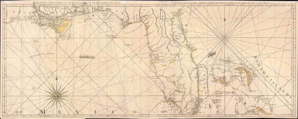
The Coast of West Florida and Louisiana. / The Peninsula and Gulf of Florida or Channel of Bahama with the Bahama Islands.
1775 (undated) 20 x 49 in (50.8 x 124.46 cm) 1 : 1560000
1775 (undated) 20 x 49 in (50.8 x 124.46 cm) 1 : 1560000
Description
This is the 1775 first edition of Thomas Jeffreys' seminal map of Florida and the Gulf Coast - considered the first large-scale map to address the region in any detail. The map is significant for its accessible delineation of Florida and the Gulf, but is made more interesting through its graphic illustration of the Spanish Treasure Fleet and its route from Havana, around Florida, and then through the Bahamas - an unspoken but open invitation to pirates and privateers.
A Closer Look
Coverage roughly embraces from the Sabine River, past the Mouths of the Mississippi, and Peninsular Florida, to include the Bahamas. Soundings are provided along the coasts, but particularly up the Florida east coast as far as St. Augustine, around Tampa, and in West Florida from Cape San Blas to New Orleans. Near the Mississippi River, there is considerable inland detail derived from Pierre Le Moyne d'Iberville (1661 - 1706) and other French explorers. In peninsular Florida there is little detail beyond river systems and the St. Marks - St. Augustine trading road. A mountain rage bisecting Florida give evidence of just how much the interior of remained a mystery. Much of the coast cartography of the peninsula can be traced to John Grear de Brahm (1718 - c. 1799), who surveyed this region between 1765 and 1771. Throughout safe anchorages, watering spots, and undersea dangers are noted.Publication History and Census
This map was engraved by Thomas Jeffreys in two sheets. The sheets can be found both as separate maps, and joined, as here. There are three states, of which this conforms to the first, published in February of 1775. Subsequent states appeared with minor revisions later in 1775, and with major revisions in 1794. Examples are well represented institutionally, but scarce to the market.Cartographer
Thomas Jefferys (1695 - November 20, 1771) was one of the most prominent and prolific map publishers and engravers of his day. Jefferys was born in Birmingham and was apprenticed to the engraver Emmanuel Bowen in 1735. Later, in the 1740s he engraved several maps for the popular periodical Gentleman's Magazine. Around 1740 Jefferys was finally able to go into business for himself and in 1746 received an appointment as 'Geographer to Fredrick, Prince of Wales,' which shortly after translated to the position of 'Royal Cartographer to King George III.' Jefferys initially specialized in compiling and re-engraving the works of earlier cartographers into more coherent cartographic wholes. Later, while not salaried position, Jefferys' appointment as 'Royal Cartographer' guaranteed preferential access to the most up to date cartographic material available, allowing him to produce new and updated charts of exceptional accuracy. He his best known for his maps of the Americas, particularly the posthumously published 1775 American Atlas, which included some of the finest and most important late colonial era maps of America ever made. Despite his prolific publishing history, royal appointments, and international publishing fame, Jefferys lived most of his life in dire economic straits. He was bailed out of bankruptcy by Robert Sayer during the production of the American Atlas. In the end, Jefferys died suddenly with very little to his name. Nonetheless, his cartographic legacy survived, and even after his death in 1771, many of his important maps continued to be published and republished by Sayer and Bennet, Conrad Lotter, Georges Louis Le Rouge, Laurie and Whittle, and others. Many attribute some of Jefferys best maps to the colorful and criminally inclined Irish cartographic genius Braddock Mead (John Green, c. 1688 - 1757), who is considered the 'secret behind Jefferys.' Jefferys was succeeded by his son, also Thomas, who had little success as a cartographer and eventually partnered with, then sold his stock and plates to William Faden - Jefferys' true heir. More by this mapmaker...
Condition
Good. Two sheets, joined. Some verso reinforcement of old fold splits.
References
Rumsey 4723.010. Stevens, H. and Tree, R., 'Comparative Cartography', in Tooley, R. V., The Mapping of America, #26(a), page 65-66.