This item has been sold, but you can get on the Waitlist to be notified if another example becomes available, or purchase a digital scan.
1953 Karl Smith Pictorial Map of Florida
Florida-karlsmith-1953$375.00

Title
Florida.
1953 (dated) 17 x 21.75 in (43.18 x 55.245 cm) 1 : 1520640
1953 (dated) 17 x 21.75 in (43.18 x 55.245 cm) 1 : 1520640
Description
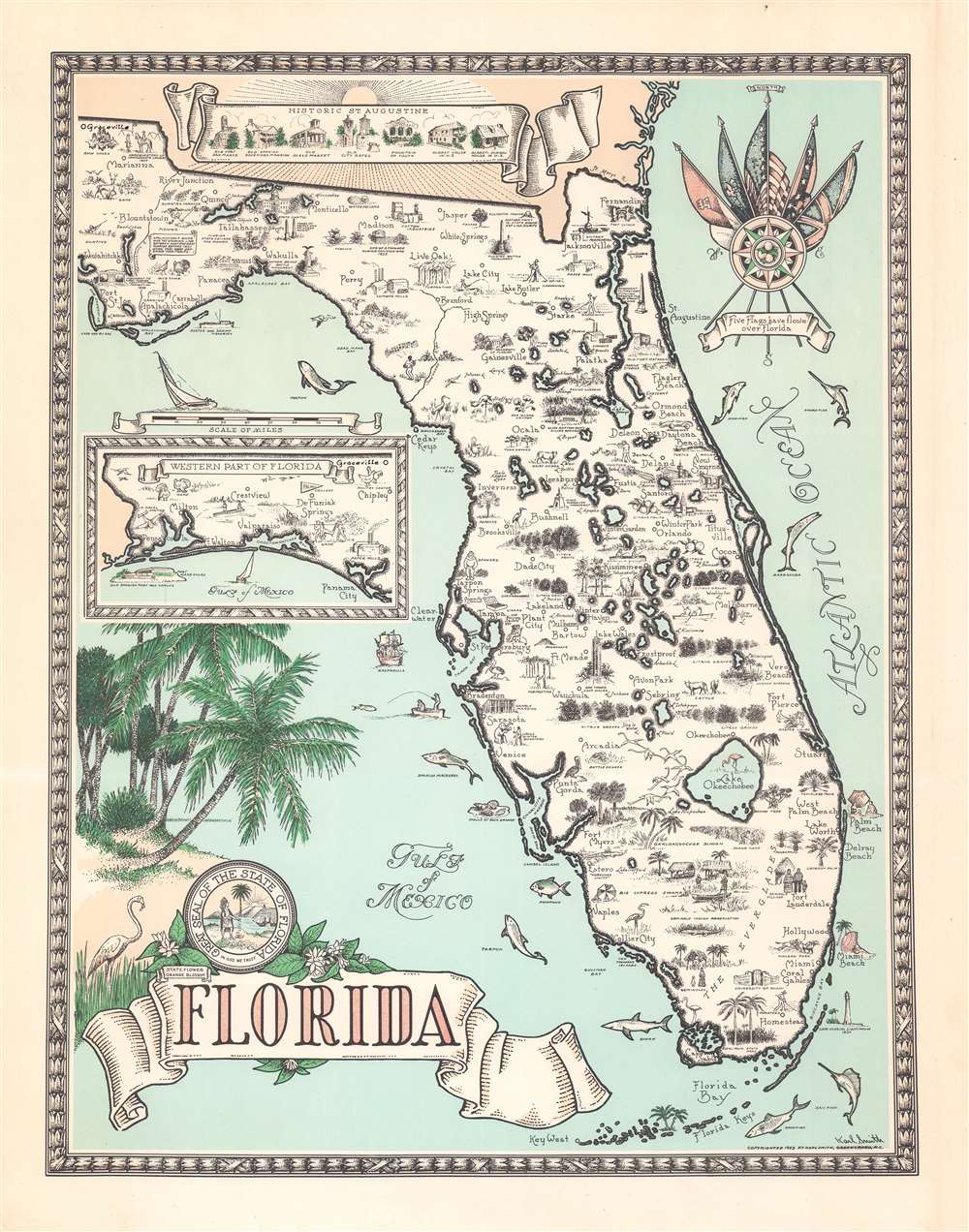
A fine example of Karl Smith's striking 1953 pictorial map of Florida. The map focuses on peninsular Florida, with the western panhandle illustrated via inset. Throughout, vignette illustrations depict life in Florida, from citrus harvesting to fishing and ranching. Florida's rich flora and fauna are also incorporated. West of Tampa, 'Gasparilla', ship of the notorious but apocryphal Spanish pirate José Gaspar, lies in wait. Other features including the '5 Flags over Florida' compass rose, a banner illustrating the historic buildings of St. Augustine, and a palm tree themed title cartouche.
Publication History and Census
This map was first issued by Karl Smith in 1940, when he was based in Louisville, Kentucky. It is part of a series of state maps initially commissioned by the Speed Art Museum of Louisville, Kentucky. Smith apparently maintained the copyrights and reissued many of his state maps in a second edition, as here in 1953 from his home in Greensboro, North Carolina. Smith's map of Florida is extremely rare to the market in any edition. We find institutional holdings of the 1953 at the David Rumsey Collection and a 1940 first edition is part of the collection of the Touchton Map Library at the Tampa Bay History Center.Cartographer
Karl J. Smith (August 28, 1895 - August 7, 1986) was an American cartographer and illustrator best known for his pictorial maps. Smith was born in Louisville, Kentucky. His first job was at Louisville Paper Company - where he apparently fell into a barrel of ink. He served in World War I (1914 - 1918). His earliest work dates to about 1934, when he was commissioned by the Speed Art Museum of Louisville, Kentucky to make pictorial maps of the states. It is unclear if he completed this project, but known maps include Kentucky, Indiana, Illinois, Ohio, Michigan, North Carolina, Arkansas, Mississippi, Florida, and California. There are likely others. Around 1950, he relocated to Greensboro, North Carolina, where he worked as advertising director for the Dillard Paper Company. Later, in the late 1950s, he issued a series of historical maps of the United States for Linweave Paper Company. Smith's style resembles that of Ernest Dudley Chase but is more playful and humorous. In addition to cartographic work, he was also considered an expert on heraldic painting. He was also an amateur historian and well-known expert on Benjamin Franklin. Smith died in Louisville, Kentucky, at 90. More by this mapmaker...
Condition
Very good.
References
Rumsey, 8692.000. Tampa Bay History Center, Touchton Map Library, #M2127 (1940 first edition).