This item has been sold, but you can get on the Waitlist to be notified if another example becomes available, or purchase a digital scan.
1925 Rand McNally Folding Sectional Map of Florida
Florida-mcnally-1925-2$600.00


Title
New Sectional Map of Florida.
1925 (undated) 40 x 41 in (101.6 x 104.14 cm) 1 : 760320
1925 (undated) 40 x 41 in (101.6 x 104.14 cm) 1 : 760320
Description
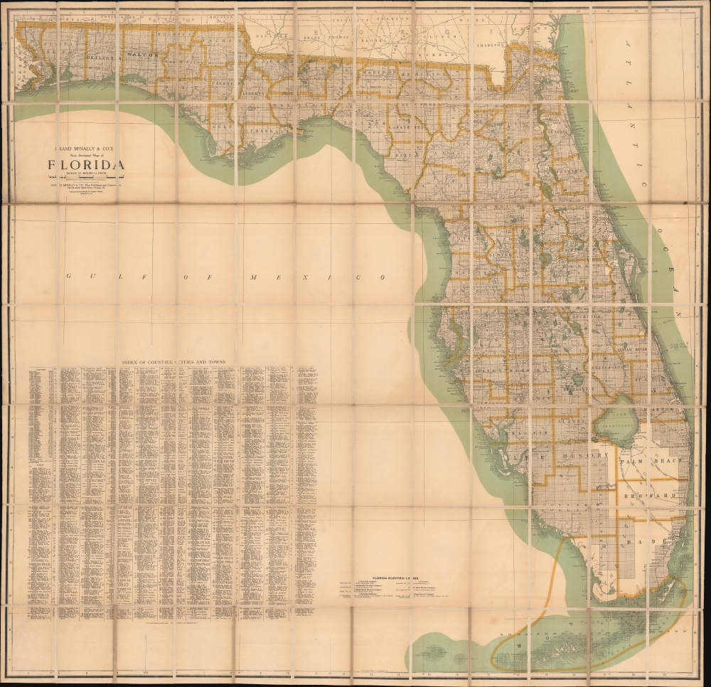
A scarce and monumentally proportioned 1925 large format map of Florida by Rand McNally. Produced at the height of the 1920s Florida Land Boom, it reflects the state as it underwent a demographic transformation.
Flagler and other Florida boosters successfully promoted it as a paradisical escape from the grimy industrial cities and cold weather of New England and the Mid-Atlantic. Land prices shot up at an astronomical rate, and developers carved entirely new cities out of wetlands in mere months. In addition to Flagler's railway, the arrival of the highway system and associated businesses (gas stations, motels, restaurants, etc.) in the 1920s made Florida more easily accessible. Nonetheless, speculation around land prices in Florida had reached irrational heights, and the damage caused by two hurricanes, followed by the financial crash of 1929, led to a collapse in the real estate market, ruining countless investors in the process.
A Closer Look
The state of Florida is presented on a massive scale with extraordinary detail throughout, noting towns, cities, rivers, electric lines, railways, coastal details, and a host of additional topographical features. Lake Okeechobee, the Everglades, Biscayne Bay, and Tampa Bay are identified. An exhaustive index of counties, cities, and towns, with their populations, is included in the lower left, as it is a key to Florida's electric rail lines. Survey grids and plats referencing the work of the U.S. Land Survey are delineated.Florida Land Boom
In the late 19th and early 20th century, Florida experienced a series of land booms and crashes; the most well-known occurred in the 1920s. The collapse of a previous land boom that established Florida as a center for the citrus industry in the 1880s - 1890s allowed speculators high on the soaring stock exchange to acquire large tracts of land at cut-rate prices. Industrialist and founder of Standard Oil Henry Flagler (1830 - 1913) seized the opportunity to build his Florida East Coast Railway and extend it to the region that would become Miami and adjacent communities on the state's southeastern coast.Flagler and other Florida boosters successfully promoted it as a paradisical escape from the grimy industrial cities and cold weather of New England and the Mid-Atlantic. Land prices shot up at an astronomical rate, and developers carved entirely new cities out of wetlands in mere months. In addition to Flagler's railway, the arrival of the highway system and associated businesses (gas stations, motels, restaurants, etc.) in the 1920s made Florida more easily accessible. Nonetheless, speculation around land prices in Florida had reached irrational heights, and the damage caused by two hurricanes, followed by the financial crash of 1929, led to a collapse in the real estate market, ruining countless investors in the process.
Publication History and Census
Rand McNally and Company of Chicago drafted and issued this map in 1925. Though undated, it includes Gulf County but not Gilchrist County, both of which were incorporated in 1925 - meaning it must have been compiled between their incorporations. This map is quite scarce. The OCLC only notes it among the holdings of the Newberry Library, while the University of Michigan, Princeton University, and Dartmouth University hold earlier editions dating back to 1884. The Touchton Map Library at the Tampa Bay History Center also holds examples from 1910 and 1913. The present example is also exceptional for being dissected and laid on linen.Cartographer
Rand, McNally and Co. (fl. 1856 - present) is an American publisher of maps, atlases and globes. The company was founded in 1856 when William H. Rand, a native of Quincy, Massachusetts, opened a print shop in Chicago. Rand hired the recent Irish immigrant Andrew McNally to assist in the shop giving him a wage of 9 USD per week. The duo landed several important contracts, including the Tribune's (later renamed the Chicago Tribune) printing operation. In 1872, Rand McNally produced its first map, a railroad guide, using a new cost effective printing technique known as wax process engraving. As Chicago developed as a railway hub, the Rand firm, now incorporated as Rand McNally, began producing a wide array of railroad maps and guides. Over time, the firm expanded into atlases, globes, educational material, and general literature. By embracing the wax engraving process, Rand McNally was able to dominate the map and atlas market, pushing more traditional American lithographic publishers like Colton, Johnson, and Mitchell out of business. Eventually Rand McNally opened an annex office in New York City headed by Caleb S. Hammond, whose name is today synonymous with maps and atlases, and who later started his own map company, C. S. Hammond & Co. Both firms remain in business. More by this mapmaker...
Condition
Very good. Light foxing. Folded, mounted on linen.
References
Newberry Library, map3C G3930 1925 .R3 (PrCt).