
1927 Mid-West Map Company Tourist Road Map of Florida

This item has been sold.
Highway Map and Guide of Florida.
Explore the Sunshine State!
Choose a Collection:
- Digital Map Information
- Suitable for large format printing
- Full resolution TIFF file
- ICC color profile embedded
- Delivered instantly via download link
This Item
Enquire
Explore the Sunshine State!
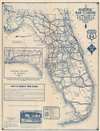
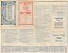
This is a c. 1927 Mid-West Map Company tourist road map of Florida created as part of a series of maps promoting Authorized Guide and Map Stations across the country. Stars mark cities throughout Florida where at least one Authorized Guide and Map Station operated. Thick dark lines highlight paved or hard surfaced roads throughout the state, with cities and towns identified along these routes. Improved roads, dirt roads, and county roads are also illustrated. Small airplane icons appear next to cities where the Department of Commerce recognized an airport or a landing field. A list of Authorized Guide and Map Stations in Florida is printed on the verso. Some of these locations are hotels and descriptions of the hotel's rates and accommodations are provided.Dating the Map
Sportswriters and fans used the nickname the Brooklyn Robins for the Brooklyn Dodgers (now the Los Angeles Dodgers) interchangeably with other nicknames between 1914 and 1931. The Brooklyn Robins first held spring training at Clearwater Athletic Field in 1923, and the map states on the verso that Clearwater 'is the training ground of the Brooklyn Robins'. Another detail indicative of a date is the presence of the U.S. Route shield. The U.S. Route shield was first installed in 1926, and since the shield appears along the right border, that is suggestive of our c. 1927 date.Publication History and Census
This map was created by the Mid-West Map Company c. 1927. This is the only known cataloged example of the present edition of this map.Condition
Good. Exhibits light wear along original fold lines. Exhibits manuscript crayon notations on recto. Exhibits small areas of infill along center fold. Text on verso.