1867 Mitchell Map of Florida (w/ Mobile, Alabama inset)
Florida-mitchell-1867$160.00
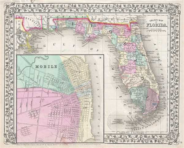

Title
County Map of Florida.
1867 (dated) 12 x 14 in (30.48 x 35.56 cm) 1 : 3500000
1867 (dated) 12 x 14 in (30.48 x 35.56 cm) 1 : 3500000
Description
This hand colored antique map of Florida is a lithographic engraving dating to 1867 by the important American map publisher Samuel Augustus Mitchell, the younger. Map features a large inset of Mobile Alabama, indicating streets and important buildings. Florida itself is shown in considerable detail with interesting references such as 'Indian Hunting Grounds' and 'Mangrove Woods.' Features the vine motif border typical of Mitchell maps from the 1865-80 period. Prepared for inclusion as plate 37 in the 1867 issue of Mitchell's New General Atlas. Dated and copyrighted, 'Entered according to Act of Congress in the Year 1867 by S. Augustus Mitchell Jr. in the Clerk's Office of the District Court of the U.S. for the Eastern District of Pennsylvania.'
Cartographer
Samuel Augustus Mitchell (March 20, 1792 - December 20, 1868) began his map publishing career in the early 1830s. Mitchell was born in Bristol, Connecticut. He relocated to Philadelphia in 1821. Having worked as a school teacher and a geographical writer, Mitchell was frustrated with the low quality and inaccuracy of school texts of the period. His first maps were an attempt to rectify this problem. In the next 20 years Mitchell would become the most prominent American map publisher of the mid-19th century. Mitchell worked with prominent engravers J. H. Young, H. S. Tanner, and H. N. Burroughs before attaining the full copyright on his maps in 1847. In 1849 Mitchell either partnered with or sold his plates to Thomas, Cowperthwait and Company who continued to publish the Mitchell's Universal Atlas. By about 1856 most of the Mitchell plates and copyrights were acquired by Charles Desilver who continued to publish the maps, many with modified borders and color schemes, until Mitchell's son, Samuel Augustus Mitchell Junior, entered the picture. In 1859, S.A. Mitchell Jr. purchased most of the plates back from Desilver and introduced his own floral motif border. From 1860 on, he published his own editions of the New General Atlas. The younger Mitchell became as prominent as his father, publishing maps and atlases until 1887, when most of the copyrights were again sold and the Mitchell firm closed its doors for the final time. More by this mapmaker...
Source
Mitchell's New General Atlas, containing maps of the various countries of the World, plans of cities, etc., (1867 edition).
Condition
Very good. Some foxing throughout. Minor edge wear. Large rips near top margin, repaired on verso.
References
Rumsey 0579.028 (1868 edition).