1851 Putnam Public Survey Map of Florida
Florida-putnam-1851$550.00

Title
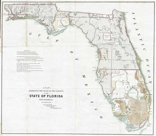
A Plat Exhibiting the State of the Surveys in the State of Florida.
1851 (dated) 22 x 25.5 in (55.88 x 64.77 cm) 1 : 1140480
1851 (dated) 22 x 25.5 in (55.88 x 64.77 cm) 1 : 1140480
Description
This is an 1851 B. A. Putnam land survey map of Florida. The map depicts the state from the Perdido River to the Atlantic Ocean and from the Florida-Georgia state line to the Everglades. Highly detailed, the township grid is labeled, along with numerous rivers, keys, and lakes. The map labels several important Seminole War forts, including Fort Bassinger, Fort Center, Fort Thompson, Fort Beynaud, and Fort Adams. The Everglades, Big Cypress, Fort Lauderdale, Lake Okeechobee, and other locations are also labeled. Townships labeled with the letter S have been sectioned, while townships labeled with the letter T have only had the exterior lines run. This information, and more, is included in a references section situated along the left border.
The most intriguing aspect of the map is the inclusion of the Arredondo Grant, bequeathed to Don Fernando de la Maza Arredondo by the Spanish crown. A holdover from Spanish rule in Florida, Arredondo's grant, and others like it, became a point of contention between the United States government and grant holders following Florida's annexation in 1821. Arredondo's case eventually arrived in the United States Supreme Court, which initially upheld his right to the land. Nonetheless, subsequent events ruled against Arredondo and the grant was dissolved. Eventually, after incredible difficulty and protest, the entire land grant system was dissolved.
Forbes Purchase, a large tract of land purchased from Spain by three American traders in the late 18th century situated in the Florida Panhandle near Apalachicola Bay, is also noted here. After Florida became part of the United States there was an attempt by the federal government to seize the land, but it was denied by the United States Supreme Court. Unfortunately, as Forbes Purchase was mostly uninhabitable swampland, it was impossible to develop and later sold off in lots.
This map was created in the Surveyor General's office and approved by Surveyor General B. A. Putnam in 1851. Published in the Report of the Commissioner of the General Land Office, 1852.
Cartographer
The General Land Office (1812 - 1946) was an independent agency charged with the administration and sale of public lands of the western territories of the United States under the Preemption Act of 1841 and the Homestead Act of 1862. During a time of frenetic energy and rapid westward expansion, the Land Office oversaw the surveying, platting, mapping and eventually the sale of much of the Western United States and Florida. The structural layout of the western United States that we see today, and many of their district and county divisions, are direct result of the early surveying work of the General Land Office. More importantly, as a branch of the Federal Government in Washington D.C. and the only agency able to legally sell and administer public lands in the western territories of the United States, the General Land Office played a pivotal role in consolidating power away from the original states and into the hands of the centralized federal government. The General Land Office was absorbed into the Department of Interior in 1849 and in 1946 merged with the United States Grazing Service to become the Bureau of Land Management. Today the Bureau of Land Management administers the roughly 246 million acres of public land remaining under federal ownership. More by this mapmaker...
Source
Report of the Commissioner of the General Land Office, (Washington) 1852.
Condition
Very good. Even overall toning. Left margin extended. Backed on archival tissue for stability. Blank on verso.