This item has been sold, but you can get on the Waitlist to be notified if another example becomes available, or purchase a digital scan.
1912 Rand McNally Map of Florida
Florida-randmcnally-1912$100.00

Title
The Rand McNally New Commercial Atlas Map of Florida.
1912 (dated) 19.25 x 27 in (48.895 x 68.58 cm) 1 : 1203840
1912 (dated) 19.25 x 27 in (48.895 x 68.58 cm) 1 : 1203840
Description
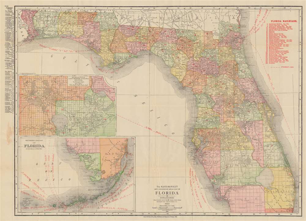
This is a 1912 Rand McNally map of Florida. Red overprinting highlights railroads and steamship lines operating in and around Florida. Thirty-three railroads are identified numerically and correspond with an index in the upper right. Among these are the Florida East Coast Railway, the Atlantic Coast Line, and the Tampa and Gulf Coast Railway. Steamships operating out of Jacksonville took travelers to Boston, New York, and Tampa, while other steamships leave Tampa for New York, Key West, Philadelphia, and Mobile. An inset in the lower left depicts the southern tip of Florida and the Keys along with steamship lines operating out of Key West to New Orleans, Galveston, New York, Tampico, Havana, and Puerto Rico. A second inset situated above the map of southern Florida focuses on Lake Orange and Volusia illustrating the extensive Levy Grants around Lake Monroe, the St. Johns River, and Lake Jessip.
In the wake of the Napoleonic Wars (1800 - 1815) European Jews were suffering extreme persecution in Europe, but in the United States they could enjoy rights as full citizens. Levy imagined his settlement, called the Pilgrimage Plantation, as a utopian haven where European Jews could escape anti-Semitism in a Moshav-like social and political setting. Unfortunately, lacking the vast capital required to develop the sprawling grants, the settlement never really took off. By 1828, only 21 Jews had settled on Levy’s land. Pilgrimage Plantation was devastated during the Second Seminole War (1835 - 1842), after which it never recovered, and the notion of an exclusively Jewish settlement in Florida was abandoned. Moreover, Levy's properties presupposed United States recognition of Spanish land grants, which the Federal government opposed. Levy was financially devastated by lengthy court battles that ultimately validated nearly 100,000 acres of his Florida grant holdings - but in the end, this was only a small portion of the total land he had amassed. He died in September 1854 and his remaining land holdings passed to heirs before being broken up and sold.
Levy's Jewish Colony in Florida
The Levy grants were land grants given to Moses Elias Levy (1782 - 1854). Levy was a Moroccan-born Sephardic Jew, Proto-Zionist, Abolitionist, and pioneer who emigrated to the United States from Mogador, Morocco. He built a fortune in the slave trade before experiencing an epiphany and turning his life towards philanthropic goals, including the establishment of a Jewish settlement in Florida and the gradual abolition of slavery. Levy himself did not receive a Florida grant, instead, in 1819 he purchased the land from his friend, the Spanish-Cuban grantee Alejandro Ramirez. The initial purchase consisted of some 53,000 acres in central Florida on which Levy planned to establish a proto-Zionist 'New Jerusalem.' Later, Levy bought up additional grants throughout central Florida.In the wake of the Napoleonic Wars (1800 - 1815) European Jews were suffering extreme persecution in Europe, but in the United States they could enjoy rights as full citizens. Levy imagined his settlement, called the Pilgrimage Plantation, as a utopian haven where European Jews could escape anti-Semitism in a Moshav-like social and political setting. Unfortunately, lacking the vast capital required to develop the sprawling grants, the settlement never really took off. By 1828, only 21 Jews had settled on Levy’s land. Pilgrimage Plantation was devastated during the Second Seminole War (1835 - 1842), after which it never recovered, and the notion of an exclusively Jewish settlement in Florida was abandoned. Moreover, Levy's properties presupposed United States recognition of Spanish land grants, which the Federal government opposed. Levy was financially devastated by lengthy court battles that ultimately validated nearly 100,000 acres of his Florida grant holdings - but in the end, this was only a small portion of the total land he had amassed. He died in September 1854 and his remaining land holdings passed to heirs before being broken up and sold.
Other Grants
The inset map and the larger map note a host of additional grants, most of which were holdovers from Spanish Florida. These include the Arredondo Grants, Young's Grant, the Rodriguez Grant, and the Miranda Grants. Arredondo's Grant and Miranda's Grant, among the largest, are interesting case studies. Beginning in the 1790s, the Spanish crown offered land grants to people courageous enough to emigrate to Florida or for meritorious service to the crown. The Spanish merchant Fernando de la Maza Arredondo controlled multiple grants, but the largest was located to the west of St. Augustine in Alachua County. It was granted to Arredondo in 1817 by Alejandro Ramirez of Havana. Miranda's Grants, after Pedro Miranda, a Spanish sailor, appear throughout the map. After Florida became a possession of the United States in 1821, these grants developed into a point of contention. Initially, the U.S. government declared it would honor the grants as long as the owner could prove legitimacy. Both Pedro Miranda and Fernando de la Maza Arredondo took their cases to the United States Supreme Court, where their rights to the land were initially affirmed. Eventually, nonetheless, both grants were dissolved by U.S. courts on the basis that they were not properly developed and therefore forfeited.Publication History and Census
This map was created and published by Rand McNally and Company in 1912. We note eight examples cataloged in OCLC: Pennsylvania State University, Duke University, the Newberry Library, Florida State University, the University of Central Florida, the University of South Florida, the University of Arizona, and the National Library of Wales. An additional example can be found at the Touchton Map Library at the Tampa Bay History Center.Cartographer
Rand, McNally and Co. (fl. 1856 - present) is an American publisher of maps, atlases and globes. The company was founded in 1856 when William H. Rand, a native of Quincy, Massachusetts, opened a print shop in Chicago. Rand hired the recent Irish immigrant Andrew McNally to assist in the shop giving him a wage of 9 USD per week. The duo landed several important contracts, including the Tribune's (later renamed the Chicago Tribune) printing operation. In 1872, Rand McNally produced its first map, a railroad guide, using a new cost effective printing technique known as wax process engraving. As Chicago developed as a railway hub, the Rand firm, now incorporated as Rand McNally, began producing a wide array of railroad maps and guides. Over time, the firm expanded into atlases, globes, educational material, and general literature. By embracing the wax engraving process, Rand McNally was able to dominate the map and atlas market, pushing more traditional American lithographic publishers like Colton, Johnson, and Mitchell out of business. Eventually Rand McNally opened an annex office in New York City headed by Caleb S. Hammond, whose name is today synonymous with maps and atlases, and who later started his own map company, C. S. Hammond & Co. Both firms remain in business. More by this mapmaker...
Condition
Very good. Light wear along original fold lines. Accompanied by original booklet.
References
Tampa Bay History Center Touchton Map Library M1569. OCLC 39520730.