1950s Rand McNally Pictorial Road Map of Florida
Florida-randmcnally-1950s-2$300.00


Title
Florida.
1950s (undated) 39.75 x 17.75 in (100.965 x 45.085 cm) 1 : 725000
1950s (undated) 39.75 x 17.75 in (100.965 x 45.085 cm) 1 : 725000
Description
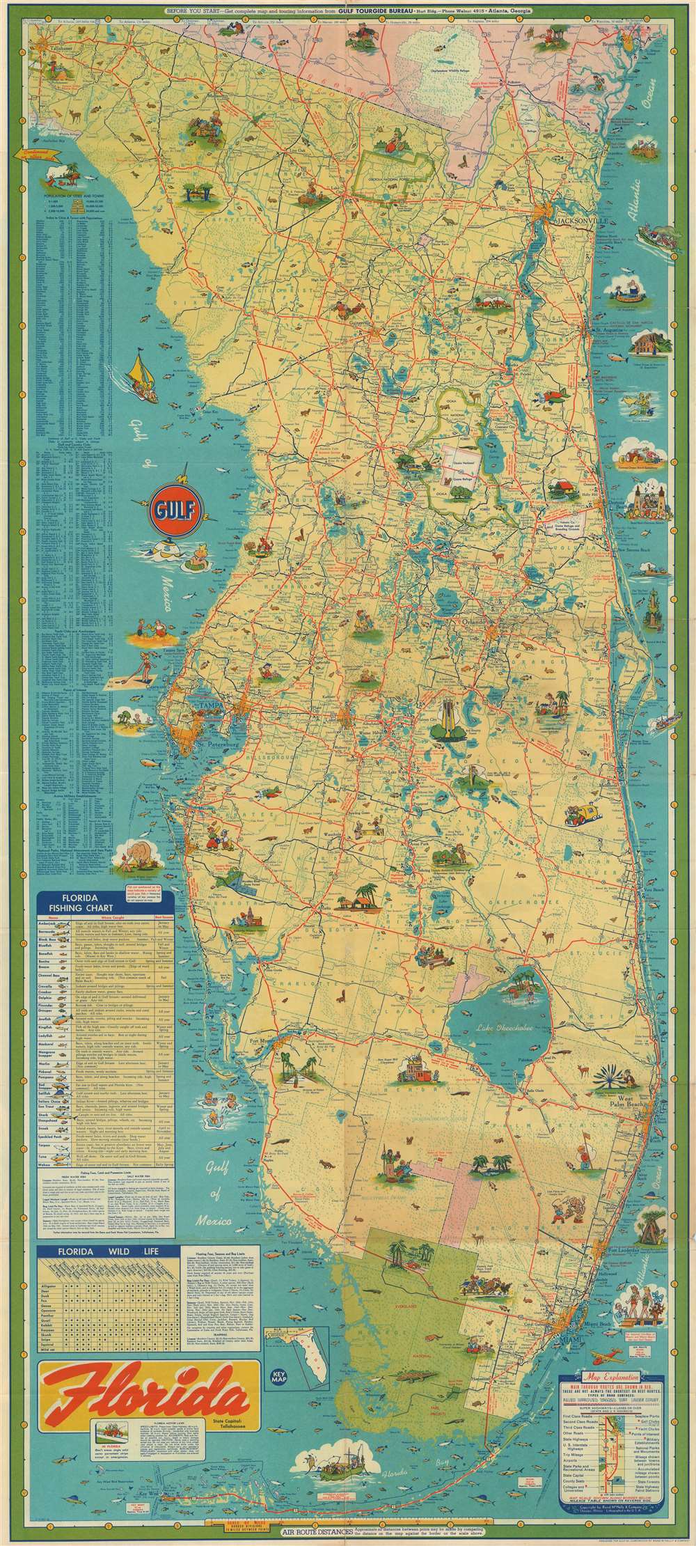
This is a c. 1950s Rand McNally pictorial road map of Florida designed for the Gulf Oil Corporation. The map depicts the state from Tallahassee and the Gulf of Mexico to the Atlantic Ocean and from Georgia to Key West. Highly detailed, myriad cities and towns throughout Florida are labeled, including Tallahassee, Tampa, St. Petersburg, Orlando, Jacksonville, West Palm Beach, Fort Lauderdale, and Miami. Everglades National Park occupies a large portion of the southern part of the state, while other national forests, state parks, and state forests are scattered throughout. Other tourist destinations, such as the Devil's Punch Bowl, the circus winter quarters, and the Ocean Beach Speedway are highlighted by small, eye-catching vignettes. Florida is a major destination for fishing enthusiasts, and this map highlights thirty-two different species of fish that could be caught in Florida's rivers and lakes, as well as along its coastlines.
Publication History and Census
This map was designed by Rand McNally for the Gulf Oil Company and published in the 1950s. At least two states of this map were published. One state (of which the offered example is representative) includes an inset key map to the right of the map's title. On the other state this key map is absent. Unfortunately we are not certain which state precedes the other.Cartographer
Rand, McNally and Co. (fl. 1856 - present) is an American publisher of maps, atlases and globes. The company was founded in 1856 when William H. Rand, a native of Quincy, Massachusetts, opened a print shop in Chicago. Rand hired the recent Irish immigrant Andrew McNally to assist in the shop giving him a wage of 9 USD per week. The duo landed several important contracts, including the Tribune's (later renamed the Chicago Tribune) printing operation. In 1872, Rand McNally produced its first map, a railroad guide, using a new cost effective printing technique known as wax process engraving. As Chicago developed as a railway hub, the Rand firm, now incorporated as Rand McNally, began producing a wide array of railroad maps and guides. Over time, the firm expanded into atlases, globes, educational material, and general literature. By embracing the wax engraving process, Rand McNally was able to dominate the map and atlas market, pushing more traditional American lithographic publishers like Colton, Johnson, and Mitchell out of business. Eventually Rand McNally opened an annex office in New York City headed by Caleb S. Hammond, whose name is today synonymous with maps and atlases, and who later started his own map company, C. S. Hammond & Co. Both firms remain in business. More by this mapmaker...
Condition
Very good. Exhibits wear along original fold lines. Verso repair at a fold intersection and at fold separations. Closed margin tear professionally repaired on verso. Text and printed maps on verso.