This item has been sold, but you can get on the Waitlist to be notified if another example becomes available, or purchase a digital scan.
1834 S.D.U.K. Map of Florida
Florida-sduk-1834$100.00

Title
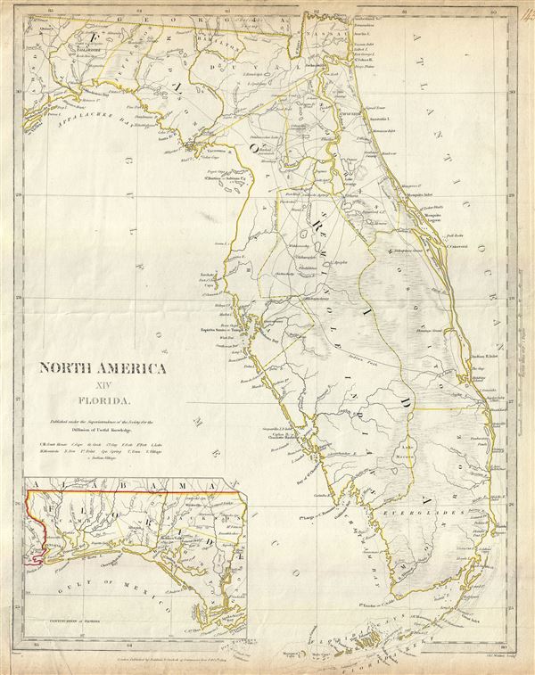
North America XIV Florida.
1834 (dated) 16 x 13.5 in (40.64 x 34.29 cm) 1 : 1770000
1834 (dated) 16 x 13.5 in (40.64 x 34.29 cm) 1 : 1770000
Description
This is an uncommon 1834 map of Florida issued by the S.D.U.K. It covers the state of Florida in its entirety with its westernmost portion depicted in an inset in the bottom left quadrant. The map identifies several Indian villages, forts, lakes, mountains, towns and a host of additional topographical features. Lake Okeechobee, here identified as Lake Macaco (as it was known in the early 19th century), is depicted to be much smaller. Territorial boundaries are marked with outline color, including the territory of the Seminole Indians.
Within a year of this map being issued, Florida would witness the outbreak of the Second Seminole War, the second of the three conflicts between the Seminole Indians and the United States Army. The Second Seminole War would last until 1842, until the army gave up the fight. It resulted in most of the Seminole being forcibly removed from Florida although some remain to this day, staunchly entrenched deep in the everglades.
Published in 1834 by Baldwin and Cradock of Paternoster Row for the Society for the Diffusion of Useful Knowledge, or S.D.U.K. Although the Society formally closed its doors in 1848, subsequent reissues of the S.D.U.K. atlas were printed well into the 1870s by Chapman and Hall, who acquired the original plates.
Cartographer
The "Society for the Diffusion of Useful Knowledge" (1826 - 1848) was a Whiggish organization founded in 1828 at the instigation of idealistic British lord Henry Peter Brougham. The admirable goal of the Society was to distribute useful information via a series of publications to the English working and middle classes. It promoted self-education and the egalitarian sharing of all knowledge. While closely tied to the London University and publishing houses on the order of Baldwin and Cradock, Chapman and Hall, and Charles Knight, the Society failed to achieve its many lofty goals in finally closed its doors in 1848. Most likely the failure of the Society resulted from its publications being too expensive for its intended lower to middle class markets and yet not large and fine enough to appeal to the aristocratic market. Nonetheless, it did manage to publish several extraordinary atlases of impressive detail and sophistication. Their most prominent atlas consisted of some 200 separately issued maps initially published by Baldwin and Cradock and sold by subscription from 1829 to 1844. Afterwards, the Society combined the maps into a single world atlas published under the Chapman and Hall imprint. In its day, this atlas was unprecedented in its quality, scope, and cost effectiveness. Today Society, or S.D.U.K. as it is commonly known, maps are among the most impressive examples of mid-19th century English mass market cartographic publishing available. The S.D.U.K. is especially known for its beautiful and accurately detailed city plans. More by this mapmaker...
Source
Maps of the Society for the Diffusion of Useful Knowledge, (London: Baldwin & Cradock), 1834.
Condition
Very good. Blank on verso. Original fold line visible. Bottom left margin includes original slit made during printing.
References
Rumsey 0890.141. Phillips (Atlases) 794.